This is an incomplete list of New York State Historic Markers in Saratoga County, New York.[1]
Listings county-wide
| Marker name[1] | Image | Date designated | Location | City or Town | Coords | Marker text | |
|---|---|---|---|---|---|---|---|
| 2 | COLONIAL INN |  |
On Middle Line Road About 1½ Mi. S/w. Of | Ballston, Town Of, New York | This Building Erected In 1797 Was For Many Years A Public Tavern | ||
| 3 | ELIPHALET BALL |  |
On Nys 50 About 3Mis. S. Of Ballston Spa | Ballston, Town Of, New York | 1722-1797 Site of original home founder, Ballston, 1770 established first real settlement in Ballston | ||
| 4 | HOME OF JAMES GORDON |  |
On Middle Line Road about 3/4 Mi. North Of Ballston Center | Ballston, Town Of, New York | Colonel Revolutionary War Member of Assembly, State Senator first supervisor Town Ballston Member of Congress Washington Visited Here 1783 | ||
| 5 | HOME OF JOHN W. TAYLOR |  |
On Nys 67 At Ballston Spa | Ballston, Town Of, New York | Member Of Congress 1831-33 Speaker Of The House Of Representatives 1821–1827 State Senator 1840 | ||
| 6 | HOME OF SAMUEL YOUNG | 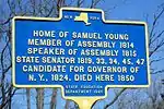 |
On Nys 50 About 3 Mi. South Of Ballston Spa | Ballston, Town Of, New York | Member Of Assembly 1814 Speaker of Assembly 1815 State Senator 1819, 33,34,45,47 Candidate For Governor Of N.Y., 1824. Died Here 1850 | ||
| 7 | MCDONALDS | 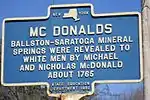 |
On Front St., Ballston Spa | Ballston, Town Of, New York | Ballston-Saratoga Mineral Springs Were Revealed To White Men By Michael And Nicholas Mcdonald About 1765 | ||
| 8 | MCDONALDS SITE |  |
On NYS Route 50 About 3/4 Mile S. Of Ballston Center | Ballston, Town Of, New York | At Shore Of Ballston Lake 1/2 Mile From This Spot Michael & Nicholas Mcdonald Built First Cabin In This Section Of State In 1763 | ||
| 9 | BALLSTON CHURCH | 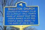 |
NE corner of Middle Line and Charlton roads | Ballston, Town Of, New York | Congregation formed 1771 by Rev. Eliphalet Ball. Fourth house of worship built 1859. Church burned in Oct. 1993, steeple saved. Rebuilt to the glory of God in 1994. | ||
| 10 | SITE OF REV BALL'S LOG CHURCH-1771 |  |
NW corner of Charlton Road and NYS Route 50 | Ballston, Town Of, New York | 42°57′23″N 73°52′02″W / 42.9562527°N 73.867117°W | Site of Rev. Ball'S log church-1771 Ballston Town Commons-1774 Stockaded fort-1775 Red Meeting House-1780 Ballston Academy-1804 | |
| 11 | SITE OF CHRIST EPISCOPAL CHURCH | 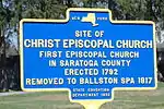 > > |
On Middle Line Road, about 1/4 Mile South Of Ballston Center | Ballston, Town Of, New York | Christ Episcopal Church First Episcopal Church In Saratoga County Erected 1792 Removed To Ballston Spa 1817 | ||
| 12 | SITE OF FIRST COURT HOUSE AND JAIL |  |
On Co. Rd. About 1½ Mis. S.w. Of Ballston Spa | Ballston, Town Of, New York | First Court House And Jail Of Saratoga County Erected 1796 Destroyed By Fire, 1816 | ||
| 13 | SITE OF HOME BERIAH PALMER | 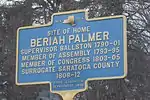 |
On NYS 146A Near Intersection With NYS 50 | Ballston, Town Of, New York | Beriah Palmer Supervisor Ballston 1790-01 Member Of Assembly 1793-95 Member Congress 1803-05 Surrogate Saratoga County | ||
| 14 | THIS BUILDING |  |
On Nys 50 About 1½ Mi. N.e. Of Burnt Hills | Ballston, Town Of, New York | Was A Public Inn During The Revolution. William Bettys, Proprietor | ||
| 15 | TOWN OF BALLSTON |  |
On Nys 339 At Burnt Hills | Ballston, Town Of, New York | Named For Eliphalet Ball Formed From Saratoga As A District April 1, 1775 Organized As A Town March 7, 1788 | ||
| 16 | CRESCENT |  |
On north Bank Of Mohawk Near Us 9 At Crescent | Halfmoon, Town Of, New York | Named From Crescent Shape Of Mohawk River At This Point. Site Of Indian Carry From Mohawk River To Hudson River. Site Of Old Crescent Bridge. | ||
| 17 | ON THE BROW OF THE HILL | On Nys 197 At Approach To Bridge To Fort Edward | Moreau, Town Of, New York | Royal Blockhouse Built During French And Indian War | |||
| 18 | BRITISH OVENS | On Bacon Hill-fort Edward County Road | Northumberland, Town Of, New York | In The Hill On The Left Were Two Large Ovens Used By The British Army While Encamped On Adjoining Flats | |||
| 19 | FORT MILLER | On Bacon Hill-fort Edward County Road | Northumberland, Town Of, New York | Built By Col. Miller July 1755 | |||
| 20 | GENERAL STARK | On Us 4 At Northumberland | Northumberland, Town Of, New York | Held This Position To Prevent British Retreat To North | |||
| 21 | HOME OF JOHN MCCREA | On Nys 32 At Bacon Hill | Northumberland, Town Of, New York | John Mccrea Brother Of Jane Mccrea Who Was Killed By Indians July 27, 1777 | |||
| 22 | HOME OF CAPTAIN MARTIN JOHN BURKE | On Nys 32 At Bacon Hill | Northumberland, Town Of, New York | Captain Martin John Burke B. 1816 - D. 1847 Graduated From West Point 1836; Was Killed In War With Mexico Aug. 20, 1847 | |||
| 23 | HOME OF COL. SIDNEY BERRY | On Bacon Hill-fort Edward County Road | Northumberland, Town Of, New York | Col. Sidney Berry Served In Revolution; First Surrogate Of County; First Supervisor Of Town | |||
| 24 | AMERICAN ENTRENCHMENTS | Saratoga National Historical Park | Saratoga Natl. Historical Pk., New York | Battles Of Sept. 19 - Oct. 7, 1777 | |||
| 25 | AMERICAN ENTRENCHMENTS | Saratoga National Historical Park | Saratoga Natl. Historical Pk., New York | Battles Of Sept. 19 - Oct. 7, 1777 | |||
| 26 | AMERICAN PERIOD | Saratoga National Historical Park | Saratoga Natl. Historical Pk., New York | Block House Site Of Fort Neilson Visitors Welcome 8:30 A.m. To 5:30 P.m. | |||
| 27 | AMERICAN PICKETS | Saratoga National Historical Park | Saratoga Natl. Historical Pk., New York | Held This High Ground South Of Middle Ravine Between The Battles Of Sept. 19 And Oct. 7, 1777 | |||
| 28 | AMERICAN PICKETS | Saratoga National Historical Park | Saratoga Natl. Historical Pk., New York | Held This High Ground South Of Middle Ravine Between The Battles Of Sept. 19 And Oct. 7, 1777 | |||
| 29 | BATTLE FIELD | Saratoga National Historical Park | Saratoga Natl. Historical Pk., New York | Cemetery Here Lies The Dust Of American Heroes Who Died That The United States Might Be Born | |||
| 30 | BATTLE WELL | Saratoga National Historical Park | Saratoga Natl. Historical Pk., New York | Sought By The Wounded Of Both Armies Scene Of Much Suffering After The Battles Of 1777 | |||
| 31 | BREYMANN REDOUBT | Saratoga National Historical Park | Saratoga Natl. Historical Pk., New York | Lasr Engagement Of Battle Of Oct. 7, 1777 | |||
| 32 | BRITISH ENTRENCHMENTS | Saratoga National Historical Park | Saratoga Natl. Historical Pk., New York | On Breymann Redoubt | |||
| 33 | BRITISH PICKETS | Saratoga National Historical Park | Saratoga Natl. Historical Pk., New York | Held This High Ground North Of Middle Ravine Between The Battles Of Sept. 19 And Oct. 7, 1777 | |||
| 34 | BRITISH PICKETS | Saratoga National Historical Park | Saratoga Natl. Historical Pk., New York | Held This High Ground North Of The Middle Ravine Between The Battles Of Sept. 19 And Oct. 7, 1777 | |||
| 35 | BRITISH CENTER | Saratoga National Historical Park | Saratoga Natl. Historical Pk., New York | October 7, 1777 General Riedesel Brunswichers Captain Pausch Battery Of 6 Pounders | |||
| 36 | BRITISH LEFT | Saratoga National Historical Park | Saratoga Natl. Historical Pk., New York | Oct. 7, 1777 Major Acland Grenadiers Major Williams Royal Artillery | |||
| 37 | BRITISH RIGHT | Saratoga National Historical Park | Saratoga Natl. Historical Pk., New York | Oct. 7, 1777 Light Infantry Earl Of Balcarras | |||
| 38 | BURGOYNE BRIDGE | Saratoga National Historical Park | Saratoga Natl. Historical Pk., New York | Built By The Invading Army Of Burgoyne | |||
| 39 | GEN. MORGAN'S RIFLE CORPS | Saratoga National Historical Park | Saratoga Natl. Historical Pk., New York | Attacked The British Redoubt After Wide Flank Movement Behind The Redoubt To The West | |||
| 40 | GENERAL DEARBORN'S | Saratoga National Historical Park | Saratoga Natl. Historical Pk., New York | Light Infantry Left Division American Attack On British Line Of Battle Oct. 7, 1777 | |||
| 41 | GENERAL LEARNED'S BRIGADE | Saratoga National Historical Park | Saratoga Natl. Historical Pk., New York | N. Y. And Mass. Regiments Center Division American Attack On British Line Of Battle Oct. 7, 1777 | |||
| 42 | GENERAL POOR'S BRIGADE | Saratoga National Historical Park | Saratoga Natl. Historical Pk., New York | N. H. And N. Y. Regiments Right Division American Attack On British Line Of Battle Oct. 7, 1777 | |||
| 43 | GREAT REDOUBT | Saratoga National Historical Park | Saratoga Natl. Historical Pk., New York | Scene Of Fighting Of First Battle Held By British Against Attacks By Arnold In Battle Of Oct. 7, 1777 | |||
| 44 | HEADQUARTERS | Saratoga National Historical Park | Saratoga Natl. Historical Pk., New York | Of Gen. Arnold Battles Of Sept. 19 - Oct. 7, 1777 | |||
| 45 | MAJOR ACLAND | Saratoga National Historical Park | Saratoga Natl. Historical Pk., New York | Made Prisoner Oct. 7, 1777 Fought Duel In Defense Of Valour Of Americans | |||
| 46 | MIDDLE RAVINE | Saratoga National Historical Park | Saratoga Natl. Historical Pk., New York | Separating Hostile Armies Between The Battles Of Saratoga | |||
| 47 | OLD POWDER | Saratoga National Historical Park | Saratoga Natl. Historical Pk., New York | Magazine Battles Of Saratoga 1777 Restored With Original Stone On Exact Site | |||
| 48 | ON THIS SPOT | Saratoga National Historical Park | Saratoga Natl. Historical Pk., New York | Francis Clerke Aide-de-camp To Burgoyne Fell Mortally Wounded October 7, 1777 | |||
| 49 | ROAD TO THE MIDDLE RAVINE | Saratoga National Historical Park | Saratoga Natl. Historical Pk., New York | Middle Ravine | |||
| 50 | SITE OF THE ORIGINAL | Saratoga National Historical Park | Saratoga Natl. Historical Pk., New York | Freeman House Center Of Right Division Of British Army After Battle Of Sept. 19, 1777 | |||
| 51 | THE SHOT THAT KILLED | Saratoga National Historical Park | Saratoga Natl. Historical Pk., New York | Gen. Fraser Oct. 7, 1777 Was Fired From Near Here By Timothy Murphy Of Morgan's Riflemen. | |||
| 52 | TO THE EAST | Saratoga National Historical Park | Saratoga Natl. Historical Pk., New York | Burgonyne's Headquarters | |||
| 53 | TO THE NORTH IS BREYMANN | Saratoga National Historical Park | Saratoga Natl. Historical Pk., New York | Redoubt The Westmost Point Of The British Entrenched Camp. Captured By The Americans On Oct. 7 When Arnold Was Severely Wounded | |||
| 54 | BRYAN HOME |  |
Maple Avenue at Rock Street, Saratoga Springs | Saratoga Springs, City Of, New York | Erected 1832 On The Site Of The Log Cabin Inn Of Alexander Bryan Revolutionary Scout | ||
| 55 | BREASTWORKS | In School Yard, Victory Mills | Saratoga, Town Of, New York | Of General Learned | |||
| 56 | BREASTWORKS | On Nys 29 At Schuylerville | Saratoga, Town Of, New York | Of General Burgoyne | |||
| 57 | CAMP OF | On Us 4 S. Of Schuylerville | Saratoga, Town Of, New York | Continental Troops Under General Gates East Across Fish Creek | |||
| 58 | COLONEL MORGAN | On Us 4 At Victory Mills | Saratoga, Town Of, New York | Crossed Creek Here As Assaulted British Camp | |||
| 59 | COLONEL MORGAN | On Nys 338 At Schuylerville | Saratoga, Town Of, New York | Held This Position To Prevent British Retreat To West | |||
| 60 | COLONEL MORGAN | On Nys 29 About 1/2 Mile West Of Schuylerville | Saratoga, Town Of, New York | Held This Position To Prevent British Retreat To West | |||
| 61 | COLONIAL AND | On Us 4 At Schuylerville | Saratoga, Town Of, New York | Revolutionary Fording Place | |||
| 62 | DERIDDER | On Nys 29 At Schuylerville | Saratoga, Town Of, New York | Horse Ferry | |||
| 63 | FIRST BRIDGE | On Nys 29 At Schuylerville | Saratoga, Town Of, New York | Here Bore Stone Tablet Now Buried In Roadway Reading "The Union- It Must Be Preserved. Gen'l Jackson. A.d. 1834" | |||
| 64 | LEARNED, GLOVER | On Us 4 At Victory Mills | Saratoga, Town Of, New York | Nixon Crossed Creek Here To Support Colonel Morgan | |||
| 65 | LINES OCCUPIED BY | On Nys 29 At Schuylerville | Saratoga, Town Of, New York | Burgoyne's German And Canadian Forces | |||
| 66 | ON THESE FIELDS | On Nys 29 At Schuylerville | Saratoga, Town Of, New York | The British Army Grounded Arms At The Surrender | |||
| 67 | POSITION OF | On Us 4 S. Of Schuylerville | Saratoga, Town Of, New York | Fraser's Corps British Light Troops October 10 To 17 1777 | |||
| 68 | SITE OF | On Us 4 At Schuylerville | Saratoga, Town Of, New York | Camp Of General Burgoyne Oct. 10 To 17 1777 | |||
| 69 | SITE OF | On Nys 29 At Schuylerville | Saratoga, Town Of, New York | Fort Hardy 1757 | |||
| 70 | SITE OF | On Nys 29 At Schuylerville | Saratoga, Town Of, New York | Continental Barracks Where General Stark Tried And Condemned The Tory Lovelace As A Spy | |||
| 71 | SITE OF | On Schuylerville-coveville County Road | Saratoga, Town Of, New York | General Gates Headquarters Previous To Surrender Of General Burgoyne Oct. 17, 1777 | |||
| 72 | SITE OF | On Schuylerville-coveville County Road | Saratoga, Town Of, New York | Surrender Of General Burgoyne To General Gates October 17, 1777 | |||
| 73 | SITE OF | On Schuylerville-coveville County Road | Saratoga, Town Of, New York | Home Of General Schuyler Burned By Burgoyne 1777 | |||
| 74 | SITE OF | On Schuylerville-coveville County Road | Saratoga, Town Of, New York | Dovegat House Headquarters General Burgoyne During Advance And Retreat Of British Army | |||
| 75 | SITE OF | On Town Rd., Victory Mills | Saratoga, Town Of, New York | Camp Of General Learned Before Surrender Of General Burgoyne | |||
| 76 | SITE OF | On Us 4 At Schuylerville | Saratoga, Town Of, New York | First Flax And Linen Mill In America Built 1810 | |||
| 77 | SITE OF | On Schuylerville-coveville County Road | Saratoga, Town Of, New York | Wheatfields Burned By Catherine Schuyler When American Settlers Fled Before Burgoyne's Advance | |||
| 78 | SITE OF | On Schuylerville-coveville County Road | Saratoga, Town Of, New York | Oldest Cotton Mill In New York State Built 1828 | |||
| 79 | SITE OF | On Nys 29 At Schuylerville | Saratoga, Town Of, New York | Camp Of General Burgoyne October 10Th To 17Th 1777 | |||
| 80 | TRENCHES | On Us 4 At Victory Mills | Saratoga, Town Of, New York | Of Burgoyne's Army | |||
| 81 | DIRCK SWART HOUSE | On Us 4 At Stillwater | Stillwater, Town Of, New York | Headquarters Aug. 3–14, 1777 Of Gen. Philip Schuyler Arnold Marched From Here To Relief Of Fort Stanwix | |||
| 82 | FERRY LANE | On Us 4 At Stillwater | Stillwater, Town Of, New York | Oct. 1777 Burgoyne's Brunswick Troops Marched Through This Lane To Vandenburgh Ferry And Prison Camp At Campbridge, Mass. | |||
| 83 | HARMANUS SCHUYLER | On Us 4 At Stillwater | Stillwater, Town Of, New York | Mansion Washington, Schuyler And Clinton Were Entertained Here In 1783 | |||
| 84 | HISTORIC SITES | On Us 4 At Stillwater | Stillwater, Town Of, New York | Fort Ingoldsby Built 1709 Fort Winslow Built 1756 Montressor's Blockhouse & Storehouse Barracks 1758 Schuyler's Supply Depot 1777 | |||
| 85 | ON THE WOODED HILL | On Us 4 At Stillwater | Stillwater, Town Of, New York | To The Left Stand Earthworks Thrown Up By Amer. Army Before Battle Of Saratoga 1777 | |||
| 86 | HALFMOON FORT | On Us 4 1 Mile North Of Broad St., Waterford | Waterford, Town Of, New York | 1689 Defense Outpost Of Albany Site Of "Ye Halfmoon" Settlement, 1764 On "Great Road" To Canada | |||
| 87 | UP COUNTRY | On Saratoga Ave., Waterford | Waterford, Town Of, New York | Erected 1830 By William Punderson Mansfield. Home Of Lewis W. Mansfield Author Of Up Country Letters, Morning Watch And Country Margins | |||
| 88 | WATER FORD |  |
Near Southeast Corner Of Broad & Second Sts., Waterford | Waterford, Town Of, New York | A Colonial Ford Across The Mohawk River From Which Waterford Derives Its Name | ||
| 89 | WATERFORD | In Flatiron Park, Broad & Sixth Sts., Waterford | Waterford, Town Of, New York | 1794 Oldest Continuously Incorporated Village In New York State | |||
| 90 | WATERFORD | In Park, Broad & First Sts. At Waterford | Waterford, Town Of, New York | 1794 Oldest Continuously Incorporated Village In New York State | |||
| 91 | WATERFORD | On Us 4 4/5 Mile North Of Broad St., Waterford | Waterford, Town Of, New York | 1794 Oldest Continuously Incorporated Village In New York State | |||
| 92 | WHITE HOMESTEAD | On Saratoga Ave., Waterford | Waterford, Town Of, New York | Erected 1830 By Hugh White Who Helped Develop Cohoes Power And Industry; R.r. Builder; Congressman; Brother Of Canvass White, C.e., | |||
| 93 | BATTLE OF WILTON |  |
On County Rd. About 1/2 Mile West Of Kings Station | Wilton, Town Of, New York | February 17, 1693 British Force Of 250 Whites & 290 Indians Engaged French & Indian Force Of "600 Or 700" Men | ||
| 94 | GRANT COTTAGE | 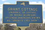 |
On US 9 At Wilton | Wilton, Town Of, New York | Entrance To Cottage On Mount McGregor Splendid Panorama Known As "Grant's Last View" | ||
| 95 | GRANT COTTAGE |  |
On County Rd. Leading To Cottage On Mt. McGregor | Wilton, Town Of, New York | Entrance To Cottage On Mount McGregor Splendid Panorama Known As "Grant's Last View" | ||
| 96 | GRANT COTTAGE | On Us 9 At Wilton | Wilton, Town Of, New York | Approaching Road On Left To House On Mount McGregor Where Ulysses S. Grant Died July 23, 1885 | |||
| 97 | GRANT COTTAGE | 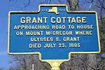 |
Mt McGregor Road | Wilton, Town Of, New York | Approaching Road To House On Mount McGregor Where Ulysses S. Grant Died July 23, 1885 | ||
| 98 | ULYSSES S. GRANT | 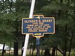 |
On Lawn In Front Of Cottage On Mount McGregor | Moreau, Town Of, New York | Ulysses S. Grant Lived Here During His Last Days June 16 To July 23, 1885 And Completed His Personal Memoirs | ||
| 99 | FORT'S FERRY |  |
Vischer Ferry Nature & Historic Preserve | Clifton Park, Town Of, New York | Fort's Ferry Site of oldest settlement in Clifton Park. Known as Canastigione, settled 1672. Nicholas Fort established a rope ferry in 1728 | ||
| 100 | LOCK 19 | 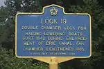 |
Vischer Ferry Nature & Historic Preserve | Clifton Park, Town Of, New York | Lock 19 Double chamber lock for raising-lowering boats. Built 1842 during enlargement of Erie Canal. Far chamber lengthened 1885 | ||
| 101 | "THE GUT", OR "THE VALLEY" | 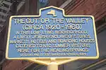 |
Corner Phila and Putnam Streets | Saratoga Springs, City Of, New York | "The Gut", or "The Valley" (circa 1920–1960) In this low-lying neighborhood a lively Jewish enclave of stores, markets, hotels and boarding houses catered to NYC summer visitors here for the healing springs | ||
| 102 | GIDEON PUTNAM BURYING GROUND |  |
South Franklin Street | Saratoga Springs, City Of, New York | Gideon Putnam (1763-1812) early settler and founding father. Developed Saratoga from wilderness to famous spa. Putnam donated this land and was the first to be buried here. The stone wall surrounds the Putnam family plot | ||
| 103 | WORLD WAR MEMORIAL PAVILION |  |
Congress Park | Saratoga Springs, City Of, New York | World War Memorial Pavilion dedicated 1931 by American Legion Aux. Unit 70 Site of the 1882 Congress Spring Victorian bandstand | ||
| 104 | DUBLIN |  |
Grand Ave. at Walworth St. | Saratoga Springs, City Of, New York | Drawn by hotel and railroad work, Irish and then Italian immigrants populated this special neighborhood from the 1840s through the 1890s | ||
| 105 | COL. ELMER ELLSWORTH |  |
Dunning Street east of US Route 9 | Malta, Town Of, New York | Col. Elmer Ellsworth born nearby April 11, 1837. Commanded Fire Zouaves. First Union officer to die in Civil War. "Mourned as a son" by Abraham Lincoln. | ||
| 106 | DUNNING STREET COMMON | 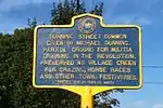 |
Dunning Street east of US Route 9 | Malta, Town Of, New York | Dunning Street Common given by Michael Dunning. Parade Ground for militia training in the Revolution. Preserved as village green for grazing, horse races and other town festivities | ||
| 107 | PARADE GROUND |  |
Dunning Street east of US Route 9 | Malta, Town Of, New York | Donated by Captain Michael Dunning in 1776 for use as a militia training ground during the Revolutionary War. It has since served Malta as a public square. | ||
| 108 | WHITNEY FIELD |  |
Bloomfield Road north of Denton Road | Greenfield, New York | Whitney Field. Built 1901 by W.C. Whitney. Named for son H.P. Whitney, a ten-goal polo player. Abandoned to farmland 1934. Found and rebuilt 1978–79. | ||
| 109 | CEMETERY, 1864 | 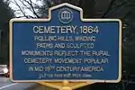 |
Ushers & Longkill Rds. | Jonesville, New York | Cemetery, 1864. Rolling hills winding paths and sculpted monuments reflect the rural cemetery movement popular in mid 19th century America. | ||
| 110 | REXFORD HOUSE |  |
South West corner of Balltown and Riverview Roads | Clifton Park, New York | 42°51′21.6″N 73°53′19.9″W / 42.856000°N 73.888861°W) | Edward Rexford from England settled here c.1763. Early home enlarged by Cyrus Rexford in 1883. | |
| 111 | KINGSLEY INN |  |
NW corner of Kingsley Road at Lake Hill Road | Burnt Hills, New York | 42°54′36.6″N 73°53′43.6″W / 42.910167°N 73.895444°W) | Established 1795 by William Kingsley Tavern on stagecoach route halfway between Ballston Spa and Schenectady | |
| 112 | BETTYS FAMILY |  |
SE corner of Hillside Cemetery, Burnt Hills NY | Burnt Hills, New York | Joseph died 1804 and Abigail died 1791, local innkeepers and unfortunate parents of Joseph, convicted traitor & spy who was hung in 1782 | ||
| 113 | BURNT HILLS BAPTIST CHURCH |  |
Kingsley Road south of Lakehill Road | Burnt Hills, New York | Founded 1783. Present church built 1839. Hillside Cemetery adjoining. 1st burial 1782. | ||
| 114 | CALVARY |  |
Lake Hill Road east of Kingsley Road | Burnt Hills, New York | Episcopal church founded by Dr. Edward Davis May 7, 1849. First service in this building was Christmas Eve, 1849 | ||
| 115 | BIRTHPLACE |  |
NW corner Washington and Fenwick Sts. | Ballston, Town Of, New York | Major-Gen Abner Doubleday Ballston Spa June 26, 1819 Founder of baseball 1839 A Civil War hero at Battle of Gettysburg 1863 | ||
| 116 | MILTON CENTRE |  |
Middle Line Road, Milton, New York | Milton, Town Of, New York | Early businesses from c.1780 to late 1800s. Gordon grist mill; Rugg wheel shop; Frink-Kellog store; S.Rugg tannery; Freelander blacksmith shop & hotel; Thompson law office | ||
| 117 | MILTON HILL |  |
Middle Line Road, Milton, New York | Milton, Town Of, New York | Area of town first settled c.1772 by David Wood family. Powell's store, Episcopal & Presbyterian churches until c.1850; School #3 to 1950s | ||
| 118 | ROSE HILL WATER TOWER |  |
Middle Line Road, Milton, New York | Milton, Town Of, New York | Square, triple-walled structure built about 1917 to store and supply running water to Thompson farm and area. Used until 1970s | ||
| 119 | CRESCENT AQUEDUCT | 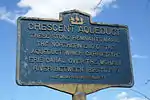 |
On north Bank Of Mohawk Near Us 9 At Crescent | Halfmoon, Town Of, New York | These stone remnants mark the northern end of the aqueduct which carried the Erie Canal over the Mohawk River between 1825 and 1915 | ||
| 120 | SITE OF | |
Middle Line Road | Ballston, Town Of, New York | First court house and jail of Saratoga County. Erected 1796. Destroyed by fire, 1816 | ||
| 121 | HOME OF |  |
Middle Line Road | Ballston, Town Of, New York | Jonathan Filer. Partially burned in Ballston invasion of 1780. Braided Indian torch found here. Family escaped and hid nearby | ||
| 122 | 1780 INVASION |  |
Middle Line Road | Ballston, Town Of, New York | Home of Tyrannis Collins militia capt. under Gordon raided by British & Indians north of here all rebel men captured & houses burned | ||
| 123 | SAMUEL DAVIS MD. |  |
Middle Line Road | Ballston, Town Of, New York | Born 1765 - died 1840 practiced medicine from here for 50 years. House was a station on the underground railroad | ||
| 124 | BALLSTON CENTER |  |
Middle Line Road | Ballston, Town Of, New York | Samuel Southard Tavern - early graveyard - post office - blacksmith shop - stores - George Washington rode through in 1783 | ||
| 125 | COUNTY SEAT | 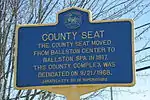 |
Ballston Spa, New York | The county seat moved from Ballston Center to Ballston Spa in 1817. This county complex was dedicated on 9/21/1968. | |||
| 126 | EMERSON's TAVERN | 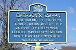 |
Ballard Road at Northern Pines Rd | Wilton, Town Of, New York | Emerson's Tavern 1790-1981 site of the first Town of Wilton meeting held Mar. 1819. First Supervisor elected was Dudley Emerson. Gen. Lafayette stayed here. | ||
| 127 | HERE IN 1800 |  |
Iron Spring Park, Front St. Ballston Spa (west side) | Ballston, Town Of, New York | A bathing green, bath house and mineral spring were used by visitors from six boarding houses and five private summer homes | ||
| 128 | HERE IN 1900 |  |
Iron Spring Park, Front St. Ballston Spa (east side)[1] | Ballston, Town Of, New York | Shoppers going to Front Street and workers walking through the tunnel from factories relaxed at a refreshment stand in the springhouse | ||
| 129 | PINE GROVE | 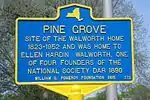 |
West side of Broadway at Ellsworth Jones Place | Saratoga Springs, City Of, New York | Site of the Walworth home 1823–1952 and was home to Ellen Hardin Walworth, one of four founders of the National Society DAR 1890 | ||
| 130 | McCREA HILL | 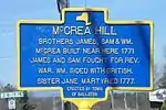 |
East side of NYS Route 50 at McCrea Hill Rd. | Ballston, Town Of, New York | 42°58′01″N 73°51′48″W / 42.966818°N 73.863369°W | Brothers James, Sam, and Wm. McCrea built near here 1771 James and Sam fought for Rev. War. Wm sided with British. Sister Jane martyred 1777. | |
| 131 | STEPHEN WHITE | 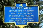 |
West side of NYS Route 50 north of Burnt Hills | Ballston, Town Of, New York | settled here-1771. Served as Cpt. in militia. taken by British. Wife Phebe was town midwife. House was social center. He died 1793 | ||
| 132 | DR. ORRA PHELPS | 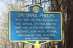 |
East side of Parkhurst Road | Wilton, Town Of, New York | 1895–1896 Dr. Phelps servet the school system and the Navy and Veterans Hospital. Botanist, ADK 46er, author, naturalist and teacher | ||
| 133 | MALTA DRIVE-IN SIGNS | 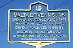 |
East side of US Route 9 north of Malta Corners | Malta, Town Of, New York | 43°00′15″N 73°47′25″W / 43.004195°N 73.790302°W) | Open-air theater started in 1949 by Sarto and Leona Smaldone, drive-in purchased in 1988 by brothers Ed and Tom Caro. In operation for over 50 years | |
| 134 | MALTA RIDGE | 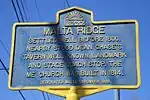 |
SE corner of US Route 9 at Malta Ave. Ext. | Malta, Town Of, New York | 43°00′41″N 73°47′22″W / 43.011350°N 73.789513°W) | Settled well before 1800. Nearby stood Dean Chase's Tavern, well-known landmark and stage coach stop. The ME church was built in 1814. | |
| 135 | MALTA RIDGE CEMETERY |  |
West side of US Route 9 at Saratoga Bridges Rd. | Malta, Town Of, New York | 43°00′59″N 73°47′27″W / 43.016402°N 73.790764°W) | Earliest recorded grave 1805. Some early family graves are Arnold, Baker, Brown, Chase, Crouch, Fish, Hill, Ireland, Millard, Phillips, Ramsdale, Reno, Riley, Rowley, Wiggins. | |
| 136 | WIGGINS - COLLAMER |  |
NW corner of US Route 9 and E. High Street | Malta, Town Of, New York | 42°59′40″N 73°47′28″W / 42.994465°N 73.791075°W) | Home of George Wiggins. Land, 1821, house c.1835 150 years in one family. Given Town of Malta 1972 by Nelson P. Collamer. Great, great-grandson. | |
| 137 | BIRTHPLACE OF | 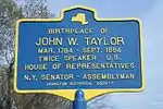 |
North side of Charlton Rd. at Valentine Rd. | Charlton, New York | 42°56′09″N 73°56′41″W / 42.935742°N 73.944757°W) | Birthplace of John W. Taylor Mar. 1784 - Sept. 1854 twice speaker - U.S. House of Representatives N.Y. Senator - Assemblyman | |
| 138 | CRUM'S PLACE | 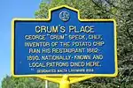 |
North side of county road 63 east of US Route 9 | Malta, Town Of, New York | 43°00′52″N 73°46′35″W / 43.0144423°N 73.7762799°W) | George "Crum" Speck, chef, inventor of the potato chip ran his restaurant 1882–1890. Nationally known and local patrons dined here. | |
| 139 | THE CHARLTON SCHOOL |  |
North side of Lake Hill Rd. | Charlton, New York | 42°54′52″N 73°55′57″W / 42.9144966°N 73.9326251°W) | Founded 1895 by John S. Hawley as the Charlton Farm School for Troubled Boys burned April 2, 1938 rebuilt for young women in 1955 | |
| 140 | PRESBYTERIAN CHURCH |  |
North side of Charlton Rd. in Charlton village | Charlton, New York | 42°56′02″N 73°57′57″W / 42.9338313°N 73.9657496°W) | organized January 3, 1786 by settlers from Freehold Monmouth Co. New Jersey present edifice built 1852 - 53. | |
| 141 | CHARLTON ACADEMY | 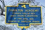 |
North side of Charlton Rd. in Charlton village | Charlton, New York | founded 1859, by Rev. James Crocker, destroyed by fire April 1946 | ||
| 142 | CHARLTON MUSEUM | 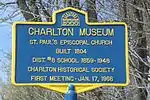 |
East side of Maple Ave. in Charlton village | Charlton, New York | 42°56′06″N 73°57′37″W / 42.9348992°N 73.9602312°W) | St. Paul's Episcopal Church built 1804 Dist. #8 school 1859-1948 Charlton Historical Society first meeting-Jan. 17, 1966 | |
| 143 | E.HUBBELL 1831 |  |
Brookline Road east of NYS Route 50 | Ballston, Town Of, New York | 42°58′39″N 73°51′04″W / 42.977372°N 73.851065°W | Late Federal Style home of Edmond and Mary Hubbell. Mr.Hubbell operated a woolen cloth manufactory on the Mourning Kill until ca.1850 | |
| 144 | TRIP-HAMMER | 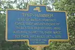 |
Brookline Road east of NYS Route 50 | Ballston, Town Of, New York | 42°58′39″N 73°51′04″W / 42.977372°N 73.851065°W | Site of water-powered forge shop and residence of Sylvester Blood.(1785-1866) and wife, Loretta. Shop made scythes and axes until 1825. | |
| 145 | MARVIN HOMESTEAD |  |
NYS Route 67 west of I-87 | Malta, Town Of, New York | 42°58′09″N 73°49′02″W / 42.9691038°N 73.8172231°W | Home of William Marvin and Susanna (Wright) Marvin, his wife. Pioneer settlers in Town of Malts. Land purchased April 2, 1772. House built ca.1790. | |
| 146 | EAST LINE |  |
NYS Route 67 at East Line Road | Malta, Town Of, New York | 42°58′17″N 73°49′51″W / 42.971297°N 73.830831°W} | An early community ca. 1780 shared by Malta and Ballston townships. ME. Church built 1809. Nearby was a hotel, a tavern, by 1837 a R.R. stop | |
| 147 | SOUTH CORINTH | 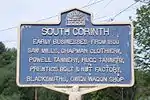 |
Chapman St. at Miner Rd. | Corinth, New York | 43°11′47″N 73°52′01″W / 43.1964447°N 73.8668746°W} | Early businesses - from 1800 saw mills, Chapman clothiery, Powell tannery, Rugg tannery, Prentiss bolt & nut factory, blacksmiths, Owen wagon shop | |
| 148 | STEVENS SCHOOL |  |
Lake Hill Road east of Kingsley Road | Ballston, Town Of, New York | 42°54′39″N 73°52′56″W / 42.9107466°N 73.8823316°W} | Built in 1916 for Burnt Hills Ballston Lake 1st consolidated and 2nd centralized district in New York State | |
| 149 | COL. ELMER E. ELLSWORTH |  |
East side of US Rte 9 North of Dunning St | Malta, Town Of, New York | 42°58′23″N 73°47′32″W / 42.973056°N 73.792127°W} | 1837-1861 Site of Childhood home First Union officer killed in the Civil War | |
| 150 | LUTHER FOREST | 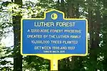 |
SE Corner of Dunning St and Fox Wander West | Malta, Town Of, New York | 42°58′18″N 73°47′06″W / 42.971674°N 73.785026°W} | A 7,000 acre forest preserve created by the Luther family 10,000,000 trees planted between 1898 and 1937 | |
| 151 | SITE OF SMITH-CALDWELL-VAN AERNEM HOME |  |
West side of Medical Park Drive | Malta, Town Of, New York | 42°58′19″N 73°48′23″W / 42.971967°N 73.806438°W} | circa 1830 vernacular Federal Style farm house contained hidden passageways characteristic of the underground railroad | |
| 152 | TURNPIKE | 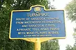 |
West side of Plank Road N. of Maxwell Dr | Clifton Park, New York | 42°52′16″N 73°46′53″W / 42.871071°N 73.781284°W} | Route of Saratoga Turnpike from Waterford to Ballston and Saratoga c.1829.A private toll road paved with wood planks in 1849. |
See also
Notes
References
- 1 2 "New York State Historic Markers". New York State Historic Markers. New York Museum. 2009-07-15. Archived from the original on 2013-03-24.
This article is issued from Wikipedia. The text is licensed under Creative Commons - Attribution - Sharealike. Additional terms may apply for the media files.