Lexington Township | |
|---|---|
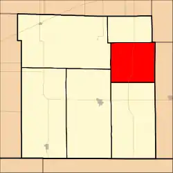 Location in Clark County | |
| Coordinates: 37°17′30″N 99°40′21″W / 37.29167°N 99.67250°W | |
| Country | United States |
| State | Kansas |
| County | Clark |
| Area | |
| • Total | 89.73 sq mi (232.4 km2) |
| • Land | 89.54 sq mi (231.91 km2) |
| • Water | 0.19 sq mi (0.49 km2) 0.21% |
| Elevation | 2,077 ft (633 m) |
| Population (2000) | |
| • Total | 83 |
| • Density | 0.9/sq mi (0.4/km2) |
| GNIS feature ID | 0470733 |
Lexington Township is a township in Clark County, Kansas, USA. As of the 2000 census, its population was 83.
Geography
Lexington Township covers an area of 89.73 square miles (232.4 km2) and contains no incorporated settlements. According to the USGS, it contains one cemetery, Lexington.
The streams of Cat Creek, Fish Creek, Granger Creek and Lone Tree Creek run through this township.
References
- "Township of Lexington". Geographic Names Information System. United States Geological Survey. Retrieved January 4, 2014.
External links
Municipalities and communities of Clark County, Kansas, United States | ||
|---|---|---|
| Cities | 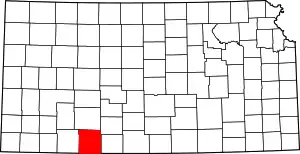 Map of Kansas highlighting Clark County | |
| Unincorporated communities | ||
| Ghost towns | ||
| Townships | ||
This article is issued from Wikipedia. The text is licensed under Creative Commons - Attribution - Sharealike. Additional terms may apply for the media files.