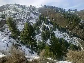
A view from Laram top
Laram Top also known as "Laram Sar" is a hill station in the Lower Dir District of Khyber Pakhtunkhwa, Pakistan at a distance of 30 km from Chakdara and 180 km from Peshawar. It is located at elevation of 7345 ft (2239 meters) above the sea level.[1][2] it is the highest peak in dir (lower) and often known as “radar” because of multiple Radar being instilled there especially for communication purposes.
See also
References
- ↑ "Laram Top". paktourismportal.com.
- ↑ "Laram Map | Pakistan Google Satellite Maps".
Wikimedia Commons has media related to Category:Laram Top.
This article is issued from Wikipedia. The text is licensed under Creative Commons - Attribution - Sharealike. Additional terms may apply for the media files.