Korop Raion
Коропський район | |
|---|---|
 Flag  Coat of arms | |
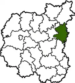 Raion location in Chernihiv Oblast | |
| Coordinates: 51°35′26″N 32°56′50″E / 51.59056°N 32.94722°E | |
| Country | Ukraine |
| Oblast | Chernihiv Oblast |
| Disestablished | 18 July 2020 |
| Admin. center | Korop |
| Area | |
| • Total | 1,312 km2 (507 sq mi) |
| Population (2020) | |
| • Total | 21,620 |
| • Density | 19.3/km2 (50/sq mi) |
| Time zone | UTC+2 (EET) |
| • Summer (DST) | UTC+3 (EEST) |
| Website | http://kpadm.cg.gov.ua/ |
Korop Raion (Ukrainian: Коропський район) was a raion (district) of Chernihiv Oblast, northern Ukraine. Its administrative centre was located at the urban-type settlement of Korop. The raion was abolished on 18 July 2020 as part of the administrative reform of Ukraine, which reduced the number of raions of Chernihiv Oblast to five. The area of Korop Raion was merged into Novhorod-Siverskyi Raion.[1][2] The last estimate of the raion population was 21,620 (2020 est.)[3]
At the time of disestablishment, the raion consisted of two hromadas:[4]
- Korop settlement hromada with the administration in Korop;
- Ponornytsia settlement hromada with the administration in the urban-type settlement of Ponornytsia.
The raion contained the village of Shabalyniv.
References
- ↑ "Про утворення та ліквідацію районів. Постанова Верховної Ради України № 807-ІХ". Голос України (in Ukrainian). 2020-07-18. Retrieved 2020-10-03.
- ↑ "Нові райони: карти + склад" (in Ukrainian). Міністерство розвитку громад та територій України.
- ↑ Чисельність наявного населення України на 1 січня 2020 року / Population of Ukraine Number of Existing as of January 1, 2020 (PDF) (in Ukrainian and English). Kyiv: State Statistics Service of Ukraine. Archived (PDF) from the original on 28 September 2023.
- ↑ "Коропська районна рада (состав до 2020 г.)" (in Russian). Портал об'єднаних громад України.
This article is issued from Wikipedia. The text is licensed under Creative Commons - Attribution - Sharealike. Additional terms may apply for the media files.