
Flintshire shown within Wales
In the United Kingdom, the term listed building refers to a building or other structure officially designated as being of special architectural, historical, or cultural significance; Grade I structures are those considered to be "buildings of exceptional interest".[1] Listing was begun by a provision in the Town and Country Planning Act 1947. Once listed, strict limitations are imposed on the modifications allowed to a building's structure or fittings. In Wales,[2] the authority for listing under the Planning (Listed Buildings and Conservation Areas) Act 1990[3] rests with Cadw.
Buildings
| Name | Location Grid Ref.[note 1] Geo-coordinates |
Date Listed | Function | Notes | Reference Number | Image |
|---|---|---|---|---|---|---|
| St Deiniol's Ash | Hawarden SJ3170466275 53°11′21″N 3°01′25″W / 53.189184632509°N 3.0235862633702°W |
14 February 1952 | House | A large timber-framed and brick house with a central range dating from the late 1500s. Set back from the road in its own gardens.[4][5] | 3 |  Upload Photo |
| Hawarden Castle (18th century) | Hawarden SJ3218665440 53°10′54″N 3°00′58″W / 53.181741894856°N 3.0161963761947°W |
14 February 1952 | House | Set in its own park, to the E of the Old Castle, and with formalised gardens to the S.[6][7] | 4 | 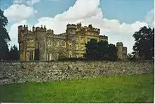 |
| Fferm Farmhouse | Leeswood SJ2790960312 53°08′06″N 3°04′44″W / 53.135091559366°N 3.0790265531435°W |
14 February 1952 | Farmhouse | Situated on the N side of the A541, approx. 0.25km to the E of Pontblyddyn.[8][9] | 5 | .jpg.webp) |
| Plas Teg | Hope SJ2869759701 53°07′47″N 3°04′02″W / 53.129706470542°N 3.0671142102998°W |
14 February 1952 | Country house | Prominently-sited, set-back from the main Wrexham to Mold road towards the NW border of the community and set into the gentle slope of the hill; accessed from the road via a pair of gated, sweeping drives.[10][11] | 7 | 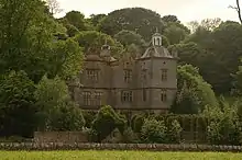 |
| Ewloe Castle | Hawarden SJ2881967523 53°12′00″N 3°04′01″W / 53.200021813865°N 3.0670339843376°W |
2 July 1962 | Castle | Situated in a wood overlooking the Wepre Brook.[12][13] | 13 |  |
| Hawarden Castle (medieval) | Hawarden SJ3194065349 53°10′51″N 3°01′11″W / 53.180892565085°N 3.0198573547638°W |
2 July 1962 | Castle (ruined) | Ruined motte and bailey type castle, with restorations carried out in 1860s and 1920s.[14][15] | 14 | .JPG.webp) |
| Church of St Cyngar | Hope SJ3096458387 53°07′06″N 3°01′59″W / 53.118195879118°N 3.0329557435863°W |
7 February 1962 | Church | Prominently-sited on a raised circular Celtic Llan in the centre of the village.[16][17] | 27 | .JPG.webp) |
| Caergwrle Castle | Caergwrle SJ3070257228 53°06′28″N 3°02′12″W / 53.107745310705°N 3.0366190661011°W |
2 July 1962 | Castle | Strikingly-sited on a high natural hilltop site in the centre of Caergwrle; accessed via a path leading from the main road.[18][19] | 28 |  |
| White Gates, Screens and Piers NW of Leeswood Hall | Leeswood SJ2501561538 53°08′45″N 3°07′21″W / 53.145709824261°N 3.1225624996547°W |
6 November 1962 | Gates/railings | Situated on the N side of the by-road between Mold and Leeswood Village, situated at the terminus of axis of the landscaped avenue which slopes downhill from the NW facade of Leeswood Hall.[20][21] | 285 | 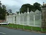 |
| Church of St Mary | Cilcain SJ1763765161 53°10′38″N 3°14′02″W / 53.177177579003°N 3.2337780691786°W |
6 November 1962 | Church | Situated in an oval churchyard close to the centre of the village.[22][23] | 295 | 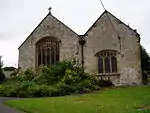 |
| Golden Grove | Llanasa SJ0890281513 53°19′22″N 3°22′09″W / 53.322693973653°N 3.3691171712522°W |
6 November 1962 | House | In its own grounds on the N side of minor road between Llanasa and Gwaenysgor.[24][25] | 301 |  |
| Church of St Eurgain and St Peter | Northop SJ2463768486 53°12′29″N 3°07′47″W / 53.208099014662°N 3.1298528017129°W |
11 June 1962 | Church | Prominently sited in the village at the corner of Church Road and Northop Road.[26][27] | 321 | 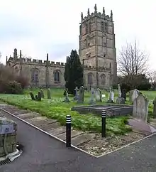 |
| Church of St Beuno and St Mary | Whitford SJ1461978183 53°17′37″N 3°16′57″W / 53.293723874942°N 3.2824151335444°W |
11 June 1962 | Church | Located NW of the cross-roads in the centre of Whitford Village, and approached by lychgates to the S and E.[28][29] | 327 | 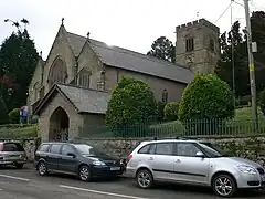 |
| Parish Church of St Mary | Mold SJ2369464165 53°10′09″N 3°08′35″W / 53.169131085652°N 3.1429356415644°W |
21 June 1953 | Church | In a spacious churchyard on high ground at upper end of the High Street.[30][31] | 383 |  |
| St Winefride's Chapel and Well | Holywell SJ1850876269 53°16′38″N 3°13′25″W / 53.277136846586°N 3.2235927513139°W |
26 July 1951 | Well | Chapel built c.1500-10 over the well associated with the martyrdom and miraculous restoration to life of St Winefride.[32][33] | 426 | 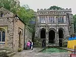 |
| Basingwerk Abbey | Holywell SJ1961177464 53°17′17″N 3°12′26″W / 53.288044664909°N 3.2073579691556°W |
19 August 1991 | Abbey (ruined) | Near the N end of the Greenfield Valley.[34][35] | 505 | 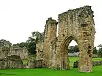 |
| Church of St Mary | Halkyn SJ2091771169 53°13′54″N 3°11′10″W / 53.231669424511°N 3.1862048431007°W |
24 February 1983 | Church | In a walled churchyard at the N end of Halkyn and opposite the Old School.[36][37] | 542 |  |
| Pentrehobyn | Leeswood SJ2496562425 53°09′13″N 3°07′25″W / 53.153674413767°N 3.1235180145985°W |
22 October 1952 | House | Set in own grounds south-east of Mold and reached along short drive.[38][39] | 14882 | Upload Photo |
| Rhual Hall (includes wall attached to the N side) |
Mold SJ2208164846 53°10′30″N 3°10′02″W / 53.17501715308°N 3.1672255092417°W |
22 October 1952 | House | Small country house set within a landscaped park.[40][41] | 14883 | Upload Photo |
| Henblas | Llanasa SJ1068381503 53°19′22″N 3°20′33″W / 53.3229081574°N 3.3423844000281°W |
22 October 1952 | House | Approximately 100m NW of Llanasa church, on the S side of the Llanasa to Gwespyr road, set back from road behind a high forecourt wall.[42][43] | 14886 | 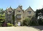 |
| Gladstone's Library | Hawarden SJ3145165919 53°11′09″N 3°01′38″W / 53.185952503443°N 3.0272955280178°W |
16 November 1994 | Library | Also known as St Deiniol's Library. Set back from the road in its own walled grounds.[44][45] | 15025 | .JPG.webp) |
| Nerquis Hall | Nercwys SJ2406360021 53°07′55″N 3°08′11″W / 53.131941192524°N 3.1364328526211°W |
22 October 1952 | Country House | To the E of a subsidiary road leading from Mold to Treuddyn, approached via a tree-lined drive and facing a large forecourt.[46][47] | 15207 | 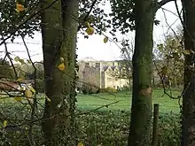 |
| Tower, Broncoed | Nercwys SJ2402361951 53°08′57″N 3°08′15″W / 53.149280712871°N 3.1374888465483°W |
22 October 1952 | House | Situated in its own park off the main N-S road from Mold by-passing the village.[48][49] | 15255 | 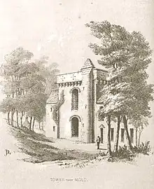 |
| Flint Castle including revetment wall of ditch, Castle Dyke Street | Flint SJ2470873344 53°15′06″N 3°07′48″W / 53.251768209079°N 3.1299391985464°W |
11 September 1995 | Castle | To NE of town centre overlooking estuary of River Dee.[50][51] | 16403 |  |
| Llettau at Pentrehobyn | Leeswood SJ2500162423 53°09′13″N 3°07′23″W / 53.153661519386°N 3.1229793220436°W |
22 October 1952 | Stone cells | Linked to the east side of Pentrehobyn House by a short screen wall.[52][53] | 17657 | Upload Photo |
| Porth Mawr, Mostyn Hall | Mostyn SJ1481180660 53°18′58″N 3°16′49″W / 53.316014253302°N 3.2802012381658°W |
22 October 1952 | Gatehouse | To the SW of Mostyn Hall.[54][55] | 21516 |  |
| Mostyn Hall | Mostyn SJ1483380706 53°18′59″N 3°16′48″W / 53.316431174442°N 3.2798834666356°W |
22 October 1952 | Hall | Surrounded by gardens and parkland and approached from the S driveway. The former gatehouse, Porth Mawr, is to the SW and a complex of farm buildings to the W.[56][57] | 21517 | 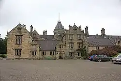 |
See also
Notes
- ↑ Sometimes known as OSGB36, the grid reference is based on the British national grid reference system used by the Ordnance Survey.
References
- ↑ "Buildings & Conservation Areas". Cadw. Retrieved 18 June 2013.
- ↑ "Coflein". online database of RCAHMW. Royal Commission on the Ancient and Historical Monuments of Wales. Retrieved 28 November 2016.
- ↑ "Planning (Listed Buildings and Conservation Areas) Act 1990". The National Archives. Retrieved 18 June 2013.
- ↑ Cadw. "St Deiniols Ash (3)". National Historic Assets of Wales. Retrieved 4 April 2019.
- ↑ "St Deiniols Ash". British Listed Buildings. Retrieved 4 April 2019.
- ↑ Cadw. "Hawarden Castle (New) (4)". National Historic Assets of Wales. Retrieved 4 April 2019.
- ↑ "Hawarden Castle (New)". British Listed Buildings. Retrieved 4 April 2019.
- ↑ Cadw. "Fferm Farmhouse (5)". National Historic Assets of Wales. Retrieved 4 April 2019.
- ↑ "Fferm Farmhouse". British Listed Buildings. Retrieved 4 April 2019.
- ↑ Cadw. "Plas Teg (7)". National Historic Assets of Wales. Retrieved 4 April 2019.
- ↑ "Plas Teg". British Listed Buildings. Retrieved 4 April 2019.
- ↑ Cadw. "Ewloe Castle (13)". National Historic Assets of Wales. Retrieved 4 April 2019.
- ↑ "Ewloe Castle". British Listed Buildings. Retrieved 4 April 2019.
- ↑ Cadw. "Hawarden Castle (Old) (14)". National Historic Assets of Wales. Retrieved 4 April 2019.
- ↑ "Hawarden Castle (Old)". British Listed Buildings. Retrieved 4 April 2019.
- ↑ Cadw. "Church of St Cyngar (27)". National Historic Assets of Wales. Retrieved 4 April 2019.
- ↑ "Church of St Cyngar". British Listed Buildings. Retrieved 4 April 2019.
- ↑ Cadw. "Caergwrle Castle (28)". National Historic Assets of Wales. Retrieved 4 April 2019.
- ↑ "Caergwrle Castle". British Listed Buildings. Retrieved 4 April 2019.
- ↑ Cadw. "White Gates, Screens and Piers NW of Leeswood Hall (285)". National Historic Assets of Wales. Retrieved 4 April 2019.
- ↑ "White Gates, Screens and Piers NW of Leeswood Hall". British Listed Buildings. Retrieved 4 April 2019.
- ↑ Cadw. "Church of St Mary (295)". National Historic Assets of Wales. Retrieved 4 April 2019.
- ↑ "Church of St Mary". British Listed Buildings. Retrieved 4 April 2019.
- ↑ Cadw. "Golden Grove (301)". National Historic Assets of Wales. Retrieved 4 April 2019.
- ↑ "Golden Grove". British Listed Buildings. Retrieved 4 April 2019.
- ↑ Cadw. "Church of St Eurgain and St Peter (321)". National Historic Assets of Wales. Retrieved 4 April 2019.
- ↑ "Church of St Eurgain and St Peter". British Listed Buildings. Retrieved 4 April 2019.
- ↑ Cadw. "Church of St Beuno and St Mary (327)". National Historic Assets of Wales. Retrieved 4 April 2019.
- ↑ "Church of St Beuno and St Mary". British Listed Buildings. Retrieved 4 April 2019.
- ↑ Cadw. "Parish Church in St Mary (383)". National Historic Assets of Wales. Retrieved 4 April 2019.
- ↑ "Parish Church in St Mary". British Listed Buildings. Retrieved 4 April 2019.
- ↑ Cadw. "St. Winifrides's Chapel & Well (426)". National Historic Assets of Wales. Retrieved 4 April 2019.
- ↑ "St. Winifrides's Chapel & Well". British Listed Buildings. Retrieved 4 April 2019.
- ↑ Cadw. "Basingwerk Abbey (505)". National Historic Assets of Wales. Retrieved 4 April 2019.
- ↑ "Basingwerk Abbey". British Listed Buildings. Retrieved 4 April 2019.
- ↑ Cadw. "Church of St Mary (542)". National Historic Assets of Wales. Retrieved 4 April 2019.
- ↑ "Church of St Mary". British Listed Buildings. Retrieved 4 April 2019.
- ↑ Cadw. "Pentrehobyn (14882)". National Historic Assets of Wales. Retrieved 4 April 2019.
- ↑ "Pentrehobyn". British Listed Buildings. Retrieved 4 April 2019.
- ↑ Cadw. "Rhual (including attached wall to the North side) (14883)". National Historic Assets of Wales. Retrieved 4 April 2019.
- ↑ "Rhual (including attached wall to the North side)". British Listed Buildings. Retrieved 4 April 2019.
- ↑ Cadw. "Henblas (14886)". National Historic Assets of Wales. Retrieved 4 April 2019.
- ↑ "Henblas". British Listed Buildings. Retrieved 4 April 2019.
- ↑ Cadw. "St Deiniol's Library (15025)". National Historic Assets of Wales. Retrieved 4 April 2019.
- ↑ "St Deiniol's Library". British Listed Buildings. Retrieved 4 April 2019.
- ↑ Cadw. "Nerquis Hall (15207)". National Historic Assets of Wales. Retrieved 4 April 2019.
- ↑ "Nerquis Hall". British Listed Buildings. Retrieved 4 April 2019.
- ↑ Cadw. "The Tower (15255)". National Historic Assets of Wales. Retrieved 4 April 2019.
- ↑ "The Tower". British Listed Buildings. Retrieved 4 April 2019.
- ↑ Cadw. "Flint Castle including Revetment Wall of Ditch (16403)". National Historic Assets of Wales. Retrieved 4 April 2019.
- ↑ "Flint Castle including Revetment Wall of Ditch". British Listed Buildings. Retrieved 4 April 2019.
- ↑ Cadw. "Llettau at Pentrehobyn (17657)". National Historic Assets of Wales. Retrieved 4 April 2019.
- ↑ "Llettau at Pentrehobyn". British Listed Buildings. Retrieved 4 April 2019.
- ↑ Cadw. "Porth Mawr, Mostyn Hall (21516)". National Historic Assets of Wales. Retrieved 4 April 2019.
- ↑ "Porth Mawr, Mostyn Hall". British Listed Buildings. Retrieved 4 April 2019.
- ↑ Cadw. "Mostyn Hall (21517)". National Historic Assets of Wales. Retrieved 4 April 2019.
- ↑ "Mostyn Hall". British Listed Buildings. Retrieved 4 April 2019.
External links
![]() Media related to Grade I listed buildings in Flintshire at Wikimedia Commons
Media related to Grade I listed buildings in Flintshire at Wikimedia Commons
This article is issued from Wikipedia. The text is licensed under Creative Commons - Attribution - Sharealike. Additional terms may apply for the media files.