This page is a partial list of listed Grade II on the National Heritage List for England in the London Borough of Waltham Forest.
| Name | Location | Type | Completed [note 1] | Date designated | Grid ref.[note 2] Geo-coordinates |
Entry number [note 3] | Image |
|---|---|---|---|---|---|---|---|
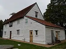
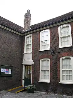
| 3, High Elms | Woodford | House | early 19th century | 4 July 1973 | TQ 40029 92160 | 1065585 | 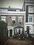 3, High Elms |
| 143, Whipps Cross Road E11, Leytonstone, London | Leytonstone | House | mid- to late-18th century | 24 February 1987 | TQ 39494 88319 | 1065567 |  Upload Photo |
| 807, Leyton High Road | Leyton | House | early 18th century | 22 October 1990 | TQ 37930 88029 | 1065572 | Upload Photo |
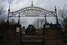
| Bakers Almshouses | Lea Bridge Road, Leyton E10 | Almshouses | 1866 | 27 September 1971 | TQ376880 51°34′30″N 0°00′55″W / 51.5749°N 0.0152°W |
1191128 | |
| Bakers Almshouses railings and gates | Lea Bridge Road, Leyton E10 | Gates | mid- to late-19th century | 24 February 1987 | TQ3769388036 | 1065594 | |
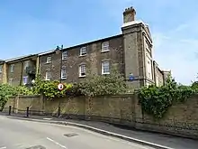
| Brookscroft | 590 Forest Road, Walthamstow | House | c. 1760 | 19 October 1951 | TQ 37754 89742 | 1065581 | 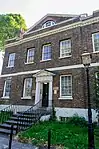 Brookscroft |
| The Bull and Crown Public House | The Green, Chingford E4 7ES | Public house | 1898 | 24 February 1987 | TQ3857694276 51°37′49″N 0°00′03″E / 51.630238°N 0.000755°E |
1065584 | |
| Butler's Retreat | Rangers Road, Chingford E4 7QH | Building | early 19th century | 30 October 1986 | TQ3979094780 51°38′04″N 0°01′07″E / 51.634466°N 0.018484061°E |
1065599 | |
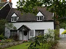
| Carbis Cottage | The Green, Chingford E4 7EN | Cottage | 17th century | 23 December 1982 | TQ3866894434 51°37′54″N 0°00′08″E / 51.631635°N 0.002146°E |
1357629 | |
| Central Parade | Hoe Street and Church Hill E17 | Commercial building | built 1957–581934-5 | 18 October 2017 | TQ3731389254 51°35′07″N 0°01′09″W / 51.58539°N 0.01925°W |
1444899 | |
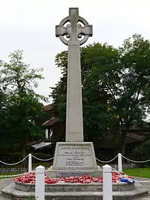
| Chingford War Memorial | King's Head Hill and The Ridgeway, Chingford E4 | War memorial cross | 1921 | 20 January 2014 | TQ3843094415 51°37′53″N 0°00′05″W / 51.631523°N 0.001298°W |
1418307 | |
| Church of St Peter and St Paul churchyard gates and gatepiers (north of church) | The Green, Chingford E4 | Gates | mid-19th century | 24 February 1987 | TQ 38531 94391 | 1065583 | Upload Photo |
| Church of St Saviour | Markhouse Road, Walthamstow E17 | Church | 1874 | 29 March 1985 | TQ 36691 87910 | 1065595 | 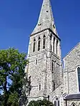 Church of St Saviour |
| Clock House | Wood Street, Walthamstow E17 3NQ | House | early 18th century | 19 October 1951 | TQ 38617 89020 | 1065569 | Upload Photo |
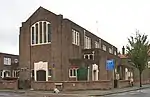
| Emmanuel Church Hall Emmanuel Parish Hall |
Hitcham Road, Leyton E10 | Church | 1906 | 24 February 1987 | TQ 36663 87449 | 1065589 | Upload Photo |
| Fetter Lane Congregational Chapel | Langthorne Road, Leyton E11 | Church | 1899 | 24 February 1987 | TQ 38571 86063 | 1065592 | 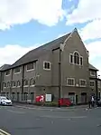 Fetter Lane Congregational Chapel |
| Friday Hill House | Simmons Lane, Friday Hill E4 | House | 19th century | 22 October 1990 | TQ3902693567 51°37′26″N 0°00′25″E / 51.623756°N 0.006971°E |
1250869 | |
| K6 Telephone Kiosk adjacent to Carnegie Library, Lea Bridge Road | Lea Bridge Road, Leyton | Telephone booth | 1935 | 16 June 1988 | TQ 37059 87611 | 1065571 | Upload Photo |
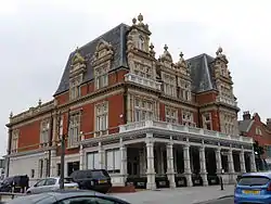
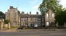
| Leyton Town Hall | 265 High Road, Leyton E10 5QN | Town hall | 1895 | 1 August 1986 | TQ 38205 86297 | 1065587 |  Leyton Town Hall |
| Leytonstone House | High Road, Leytonstone E11 1HR | House | probably 18th century | 27 May 1954 | TQ3974287771 51°34′17″N 0°00′54″E / 51.5715°N 0.015°E |
1065588 | 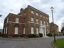 Leytonstone House |
| Metal railing to Chingford Mill Pumping Station | Lower Hall Lane, Chingford | Fence | 1895 | 2 August 1999 | TQ 36279 92467 | 1065575 | Upload Photo |
| Old Butchers Shop adjacent to Number 76 | 78 Wood Street, Walthamstow E17 | Butcher shop | probably late 18th century | 16 July 1984 | TQ 38335 89711 | 1065568 | 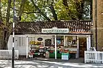 Old Butchers Shop adjacent to Number 76 |
| Orford House Social Club | 73 Orford Road, E17 | Social club | early 19th century | 7 May 1980 | TQ 37709 88880 | 1065597 |  Orford House Social Club |
| Our Lady of Grace and St Teresa of Avila | 1 King's Road, Chingford E4 7HP | Church | 1930 | 16 July 1997 | TQ3863594277 51°37′49″N 0°00′06″E / 51.630232°N 0.001607°E |
1271998 | |
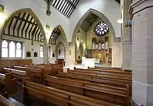
| Parish Church of Emmanuel | Lea Bridge Road, Leyton E10 | Church | built 1934–35 | 24 February 1987 | TQ3669587422 51°34′09″N 0°01′45″W / 51.569111°N 0.029073°W |
1065593 | |
| Pimp Hall Dovecote | Kings Road, Chingford E4 | Dovecote | 17th century | 28 June 1954 | TQ 38855 93819 | 1065591 | Upload Photo |
| The Pump House | South Access Road, Walthamstow E17 8AX | House | 19th century | 26 October 1999 | TQ3629688261 51°34′36″N 0°02′04″W / 51.5767°N 0.0345°W |
1379203 | |
| St Andrew's Church, Leytonstone | Colworth Road, Leytonstone E11 1JD | Church | built 1887-1893 | 27 February 2006 | TQ3921388201 51°34′32″N 0°00′26″W / 51.575429°N 0.007328°W |
1391544 | |
| St Barnabas Parish Hall | St Barnabas Road, Walthamstow | Church hall | 1902 | 24 February 1987 | TQ 37253 88281 | 1065566 | Upload Photo |
| St John the Baptist's Church, Leytonstone | High Road, Leytonstone E11 1HH | Parish Church | built 1832-1833 | 24 February 1987 | TQ3946687459 51°34′08″N 0°00′39″W / 51.5688°N 0.0109°W |
1357631 | |
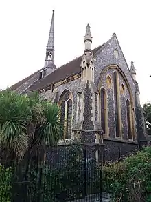
| St Peter-in-the-Forest | Woodford New Road, Walthamstow E17 3PP | Church | 1840 | 14 April 2009 | TQ3908789497 51°35′14″N 0°00′23″E / 51.587203°N 0.006266°E |
1393232 | |
| Vestry House Museum | Vestry Road, Walthamstow E17 9NH | House | 18th century | 19 October 1951 | TQ3777889118 51°35′00″N 0°00′45″W / 51.583333°N 0.0125°W |
1191188 | |
| Waltham Forest Town Hall | Forest Road E17 4JF | Building | 20th century | 9 March 1982 | TQ3770589909 51°35′28″N 0°00′49″W / 51.591111°N 0.013611°W |
1190868 | |
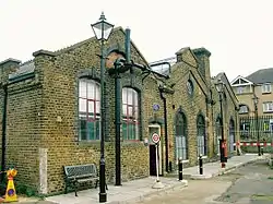
| Walthamstow Tramway and offices and depot | Chingford Road, Walthamstow | Railroad depot | 1905 | 3 August 1993 | TQ 37316 90130 | 1065573 | Upload Photo |
| Water Turbine House, Chingford Mill Pumping Station | Lower Hall Lane, Chingford | Pumping station | 1891 | 2 August 1993 | TQ 36245 92428 | 1065574 | Upload Photo |
| West Ham Union Workhouse | Langthorne Road E11 | Workhouse | built 1839-41 | 24 February 1987 | TQ3901485919 51°33′18″N 0°00′14″E / 51.55502°N 0.00383°E |
1191099 | |
| Woodford County High School For Girls | High Road, Woodford Green IG8 9LA | House (now a school) | 1768 | 19 October 1951 | TQ3987891783 51°36′27″N 0°01′07″E / 51.6075°N 0.0186°E |
1191027 |
.jpg.webp)


.jpg.webp)
.JPG.webp)
See also
Notes
- ↑ The date given is the date used by Historic England as significant for the initial building or that of an important part in the structure's description.
- ↑ Sometimes known as OSGB36, the grid reference is based on the British national grid reference system used by the Ordnance Survey.
- ↑ The "List Entry Number" is a unique number assigned to each listed building and scheduled monument by Historic England.
External links
 Media related to Grade II listed buildings in the London Borough of Waltham Forest at Wikimedia Commons
| Districts |
|   |
|---|---|---|
| Attractions |
| |
| Street markets | ||
| Parks and open spaces |
| |
| Constituencies |
| |
| Tube and rail stations | ||
| Other topics | ||
| ||
This article is issued from Wikipedia. The text is licensed under Creative Commons - Attribution - Sharealike. Additional terms may apply for the media files.