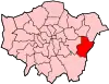
This page is a list of the 101 Grade II listed buildings in the London Borough of Bexley. There are also four Grade II-listed entries on the Register of Historic Parks and Gardens of Special Historic Interest in England.[1]
Listed buildings
| Name | Location | Type | Completed [note 1] | Date designated | Grid ref.[note 2] Geo-coordinates |
Entry number [note 3] | Image |
|---|---|---|---|---|---|---|---|
| 1 and 3, Bexley High Street | Bexley | Houses | Late 18th century | 17 December 1980 | TQ 49304 73616 | 1064242 | .jpg.webp) 1 and 3, Bexley High Street |
| 2 K6 telephone kiosks outside Number 11 | Bourne Road, Bexley | Telephone booths | 1935 | 13 July 1987 | TQ 49582 73654 | 1064213 | 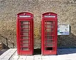 2 K6 telephone kiosks outside Number 11 |
| 7 and 9, Bexley High Street, Bexley | Bexley | Houses | 18th century | 17 December 1980 | TQ 49326 73615 | 1359376 | .jpg.webp) 7 and 9, Bexley High Street, Bexley |
| 8 Upton Road | Bexleyheath | House | c. 1856 | 17 December 1980 | TQ 48162 75320 51°27′27″N 0°07′52″E / 51.4575°N 0.1312°E |
1064205 |  Upload Photo |
| 10–16, Burnt Oak Lane | Sidcup | Houses | 1874 | 11 September 1985 | TQ 46163 72993 51°26′14″N 0°06′05″E / 51.4371°N 0.1015°E |
1359401 | 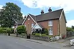 10–16, Burnt Oak Lane |
| 16, North Cray Road | Bexley | House | Late 18th century | 17 December 1980 | TQ 49726 73373 | 1064235 | 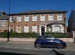 16, North Cray Road |
| 25 and 27 Halfway Street | Sidcup | Houses | 15th or 16th century | 17 December 1980 | TQ 46094 72917 | 1188383 | .jpg.webp) 25 and 27 Halfway Street |
| 28 and 30, Erith High Street | Erith | Houses | 18th century | 3 July 1973 | TQ 51557 78091 | 1064227 | .jpg.webp) 28 and 30, Erith High Street |
| Number 33 (Farm Cottage) and Number 35 | Halfway Street, Sidcup | Houses | Probably 16th century | 17 December 1980 | TQ 46051 72920 51°26′11″N 0°05′59″E / 51.4365°N 0.0998°E |
1359412 | Upload Photo |
| 34, North Cray Road | Bexley | House | c. 17th or early 18th century | 17 December 1980 | TQ 49698 73289 | 1188453 | 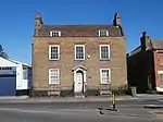 34, North Cray Road |
| 34 and 36, Bexley High Street | Bexley | Houses | 1787 | 17 December 1980 | TQ 49424 73546 | 1064246 | .jpg.webp) 34 and 36, Bexley High Street |
| 56–62, Bexley Lane | Crayford | House | 18th century | 17 December 1980 | TQ 51182 74836 | 1359380 | 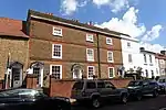 56–62, Bexley Lane |
| 57 and 59, Bexley High Street, Bexley | Bexley | Houses | Late 17th or early 18th century | 1 October 1953 | TQ 49448 73590 | 1359377 | .jpg.webp) 57 and 59, Bexley High Street, Bexley |
| 64, Bexley Lane | Crayford | House | Late 18th or early 19th century | 17 December 1980 | TQ 51171 74831 | 1188219 | 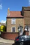 64, Bexley Lane |
| 71 Danson Road | Bexleyheath | House | 1934 | 18 July 2003 | TQ 47623 74859 | 1390524 | 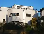 71 Danson Road |
| 101–105, Bexley High Street, Bexley | Bexley | Houses | Mid-18th century | 5 August 1974 | TQ 49656 73527 | 1359378 | 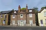 101–105, Bexley High Street, Bexley |
| Number 152 (Rose Cottage) and Number 154 | North Cray Road, North Cray | Houses | c. 16th–17th centuries | 17 December 1980 | TQ 48803 72307 51°25′49″N 0°08′21″E / 51.4302°N 0.1391°E |
1064237 | 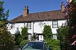 Number 152 (Rose Cottage) and Number 154 |
| 172, 172A and 172B, Old Road | Crayford | Houses | 17th century | 17 December 1980 | TQ 51261 74994 | 1064223 | .jpg.webp) 172, 172A and 172B, Old Road |
| 180–188, Rectory Lane | Foots Cray | Houses | 1737 | 25 August 1954 | TQ 47379 71011 | 1188531 | .jpg.webp) 180–188, Rectory Lane |
| Abbeyhill (Montrose Park Residents Club) | 158 Hurst Road, Sidcup | House | c. 1830 | 17 December 1980 | TQ 47143 73062 | 1064230 |  Abbeyhill (Montrose Park Residents Club) |
| Albion Villas | 65 and 67 Woolwich Road, Bexleyheath | Houses | 1866 | 3 December 1982 | TQ 49221 75504 | 1064209 |  Albion Villas |
| Barn at Hall Place | Bourne Road, Bexley | Barn | 17th century | 1 October 1953 | TQ 50210 74328 | 1359381 | .jpg.webp) Barn at Hall Place |
| Bexley College (former Erith Technical Institute) including attached walls railings and gatepiers | Erith Road, Belvedere | School | 1906 | 23 July 1999 | TQ 49823 78412 | 1387547 | 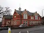 Bexley College (former Erith Technical Institute) including attached walls railings and gatepiers |
| Bowling Pavilion, Foots Cray Place | Rectory Lane, Foots Cray | Garden building | 1903 | 17 July 1989 | TQ 47421 71610 | 1064215 | 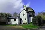 Bowling Pavilion, Foots Cray Place |
| Brooklands | 38 Bexley Lane, Crayford | House | 18th century | 20 May 1952 | TQ 51240 74862 | 1188215 | 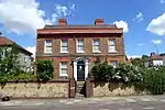 Brooklands |
| Caretaker's House at Lamorbey Park | Burnt Oak Lane, Sidcup | House | c. 1790 | 17 December 1980 | TQ 46540 73210 | 1064221 | 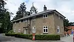 Caretaker's House at Lamorbey Park |
| Chapel House | 497 Blackfen Road, Sidcup | House | 1761 | 17 December 1980 | TQ 47296 74256 | 1064248 | .jpg.webp) Chapel House |
| Christ Church Parish Church | Broadway, Bexleyheath | Church | 1877 | 17 December 1980 | TQ 48855 75334 | 1359404 | .jpg.webp) Christ Church Parish Church |
| Christ Church Vicarage | Broadway, Bexleyheath | House | 1868 | 17 December 1980 | TQ 48894 75365 | 1064219 | .jpg.webp) Christ Church Vicarage |
| Clock Tower at west angle of Market Place | Broadway, Bexleyheath | Clocktower | 1911 | 17 December 1980 | TQ 49236 75239 | 1064220 | 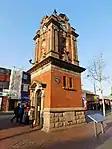 Clock Tower at west angle of Market Place |
| Coal Duty Boundary Marker (in the fence to the back of the garden of Number 57 Baldwyn's Park) and adjacent iron bollard | Tile Kiln Lane, Bexley | Coal tax post | 1861 | 17 December 1980 | TQ 50671 72493 | 1188545 | .jpg.webp) Coal Duty Boundary Marker (in the fence to the back of the garden of Number 57 Baldwyn's Park) and adjacent iron bollard |
| Coal Duty Boundary Marker (in the grounds of the Old Orchard) | East Rochester Way, Bexley | Coal tax post | 1861 | 17 December 1980 | TQ 51197 73967 | 1064226 | Upload Photo |
| Coal Duty Boundary Marker (on foreshore, at mouth of River Darenth, West Bank) | near Wallhouse Road, North End | Coal tax post | 1851 | 17 December 1980 | TQ 54013 78078 | 1064206 | 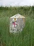 Coal Duty Boundary Marker (on foreshore, at mouth of River Darenth, West Bank) |
| Coal Duty Boundary Marker (on the east side of Railway Line, north side of Stanham River) | Willow Walk, Crayford | Coal tax post | 1851 | 17 December 1980 | TQ 53146 75093 | 1064208 | Upload Photo |
| Coal Duty Boundary Marker (on the south side of Number 1) | Dartford Road, Bexley | Coal tax post | 1861 | 17 December 1980 | TQ 50701 72875 | 1188345 | .jpg.webp) Coal Duty Boundary Marker (on the south side of Number 1) |
| Coal Duty Boundary Marker (on west side opposite Number 205) | Station Road, Crayford | Coal tax post | 1861 | 17 December 1980 | TQ 51640 73865 | 1359398 | .jpg.webp) Coal Duty Boundary Marker (on west side opposite Number 205) |
| Cray Hall | 141 North Cray Road, North Cray | House | c. 1830 | 17 December 1980 | TQ 48481 71142 | 1064240 | Upload Photo |
| Cray House | 96 Bexley High Street, Bexley | House | Late 18th century | 1 October 1953 | TQ 49668 73488 | 1064247 | .jpg.webp) Cray House |
| Crayford War Memorial in grounds of Crayford Manor | Grounds of Crayford Manor, Mayplace Road East, Dartford, Crayford, London DA1 4HB | War memorial | 1954 | 13 November 2012 | TQ5099375500 | 1410311 | .jpg.webp) Crayford War Memorial in grounds of Crayford Manor |
| The Crook Log Public House | Crook Log, Bexleyheath | Pub | 18th century | 17 December 1980 | TQ 47818 75496 | 1359408 | 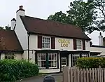 The Crook Log Public House |
| Dairy at Lamorbey Park | Burnt Oak Lane, Sidcup | Dairy | c. 1790 | 17 December 1980 | TQ 46522 73182 | 1359406 | Upload Photo |
| Dower House | North Cray Road, North Cray | House | c. 1820 | 17 December 1980 | TQ 48751 72138 | 1294717 | 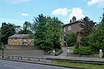 Dower House |
| East Wickham Farmhouse | Wickham Street, East Wickham | House | Possibly 15th century | 17 December 1980 | TQ 46618 76859 | 1359400 | Upload Photo |
| Erith (Christ Church) War Memorial | Christ Church, Victoria Road, Erith DA8 3AN | War memorial | 10 April 2017 | TQ5122977911 | 1445231 | .jpg.webp) Erith (Christ Church) War Memorial | |
| Erith Library | Walnut Tree Road, Erith | Library | 1906 | 7 March 1996 | TQ 51322 78072 | 1255449 | .jpg.webp) Erith Library |
| First World War Memorial at St John the Baptist Church, Erith | St John the Baptist Churchyard, West Street, Erith, London DA8 1AN | War memorial | 1921 | 19 October 2017 | TQ5077978700 | 1445491 | .jpg.webp) First World War Memorial at St John the Baptist Church, Erith |
| Five Arch Bridge | North Cray Road, Foots Cray Meadows, North Cray | Bridge | c. 1781 | 17 December 1980 | TQ 48227 71880 | 1188471 | .jpg.webp) Five Arch Bridge |
| Former Fosters Primary School | Upper Wickham Lane, Bexley | School | 1879 | 20 November 1997 | TQ4666676137 | 1031526 | Upload Photo |
| Garden walls to north of Frognal House | Frognal Avenue, Sidcup | Walls | 18th century | 17 December 1980 | TQ 46506 70866 | 1359411 | .jpg.webp) Garden walls to north of Frognal House |
| Granary approximately 25 metres south south east of Hall Place | Bourne Road, Bexley | Granary | Early 19th century | 17 December 1980 | TQ5019574314 | 1064233 | .jpg.webp) Granary approximately 25 metres south south east of Hall Place |
| Granary at Little Mascal Farm | Cocksure Lane, North Cray | Granary | Early 19th century | 25 October 1985 | TQ 49197 72154 | 1064210 | Upload Photo |
| High Street House | 123 Bexley High Street, Bexley | House | 1761 | 1 October 1953 | TQ 49730 73491 | 1064245 | .jpg.webp) High Street House |
| Jays Cottages | 1, 2, and 2A Blendon Road, Bexley | Houses | Late 18th or early 19th century | 17 December 1980 | TQ 47589 74249 | 1064249 | .jpg.webp) Jays Cottages |
| K6 telephone kiosk | Bexley High Street, Bexley | Telephone booth | 1936 | 13 July 1987 | TQ 49416 73544 | 1064214 | .jpg.webp) K6 telephone kiosk |
| The King's Head Inn | 65 Bexley High Street, Bexley | Pub | 16th or early 17th century | 1 October 1953 | TQ4951373622 51°26′31″N 0°09′00″E / 51.441863°N 0.149894°E |
1064244 | |
| Lamorbey Park[note 4] | Burnt Oak Lane, Sidcup | House | 25 August 1954 | TQ 46585 73138 | 1359405 | ||
| Large Barn at Howbury Farm | Whitehall Lane, North End | Barn | Early 17th century | 20 May 1952 | TQ 52725 76701 | 1064207 | 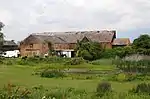 Large Barn at Howbury Farm |
| Lodge to Hurstmere School | 189 Hurst Road, Sidcup | School | Late 19th century | 17 December 1980 | TQ 47089 73064 | 1188388 | 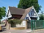 Lodge to Hurstmere School |
| The Long Shed (part of David Evans Limited Factory at Number 7) | London Road, Crayford | Agricultural building | Probably 18th century | 24 June 1980 | TQ 51103 74779 | 1359413 | .jpg.webp) The Long Shed (part of David Evans Limited Factory at Number 7) |
| Loring Hall | 8 Water Lane, North Cray | House | c. 1760 | 25 August 1954 | TQ 48816 72381 | 1359399 | .jpg.webp) Loring Hall |
| Lychgate to south west of Parish Church of St Mary the Virgin | Manor Road, Bexley | Gate | Late 19th century | 17 December 1980 | TQ 49769 73422 | 1064232 | 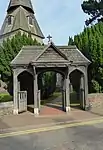 Lychgate to south west of Parish Church of St Mary the Virgin |
| Lychgate to west of Parish Church of St Paulinus | Perry Street, Crayford | Gate | Late 19th century | 17 December 1980 | TQ 51143 75108 | 1064200 | .jpg.webp) Lychgate to west of Parish Church of St Paulinus |
| The Manor House | Manor Road, Bexley | House | c. 1536 | 17 December 1980 | TQ4984773485 | 1294730 | .jpg.webp) The Manor House |
| Manor House | The Green, Sidcup | House | Late 18th century | 25 August 1954 | TQ 46257 71565 | 1064229 | 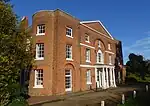 Manor House |
| Milestone on pavement slightly to south of axis of Numbers 494 | Footscray Road, Longlands | Milestone | 18th century | 8 June 1973 | TQ 44431 72575 | 1358949 | .jpg.webp) Milestone on pavement slightly to south of axis of Numbers 494 |
| North Cray War Memorial | St James Church, North Cray Road, North Cray | War memorial | 1920 | 3 July 2017 | TQ4842971761 | 1444904 | 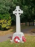 North Cray War Memorial |
| The Old House | 170 Rectory Lane, Foots Cray | House | Early 19th century | 25 August 1954 | TQ 47398 71034 | 1359396 | 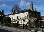 The Old House |
| One Bell Public House | 170 Old Road, Crayford, London DA1 4DY | Pub | 18th century | 17 December 1980 | TQ 51243 74991 51°27′13″N 0°10′31″E / 51.45374°N 0.175388°E |
1064198 | |
| Orchard House | 62 Woolwich Road, Bexleyheath DA7 4HU | House | Early to mid-19th century | 17 December 1980 | TQ 49192 75460 | 1294681 | .jpg.webp) Orchard House |
| Original building of former Bexley National Schools | Bourne Road, Bexley | School | 1834 | 30 August 1974 | TQ 49605 73885 | 1188284 | 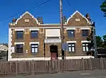 Original building of former Bexley National Schools |
| Outhouse to north east of Red House | Red House Lane, Bexleyheath | Outhouse | 1859 | 17 December 1980 | TQ 48146 75136 | 1064204 | .jpg.webp) Outhouse to north east of Red House |
| Parish Church of All Saints | Nuxley Road, Belvedere | Church | 1853 | 17 December 1980 | TQ 49256 78289 | 1064197 |  Parish Church of All Saints |
| Parish Church of St James | North Cray Road, North Cray | Church | 1637–1871 | 17 December 1980 | TQ 48406 71755 | 1064238 | .jpg.webp) Parish Church of St James |
| Parish Church of St John the Evangelist | Parkhill Road, Bexley | Church | 1882 | 17 December 1980 | TQ 49088 73667 | 1064199 | 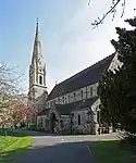 Parish Church of St John the Evangelist |
| Parish Church of St John the Evangelist | Church Avenue, Sidcup | Church | 1901 | 17 December 1980 | TQ 46454 71558 | 1064222 | .jpg.webp) Parish Church of St John the Evangelist |
| Pillar box beside Number 48 at junction with Parkhurst Road | Parkhill Road, Bexley | Pillar box | c. 1872–1879 | 17 December 1980 | TQ 49068 73716 | 1359433 | .jpg.webp) Pillar box beside Number 48 at junction with Parkhurst Road |
| Place Cottage | The Green, Sidcup | House | Late 16th or 17th century | 17 December 1980 | TQ 46411 71518 | 1188375 | .jpg.webp) Place Cottage |
| Post on land of Gun Club, on east side of lane which forms the west boundary of the shooting ground and the west boundary of the former Borough of Dartford | East Rochester Way, Bexley | Coal tax post | Mid-19th century | 25 September 1975 | TQ 51198 73966 | 1336368 | .jpg.webp) Post on land of Gun Club, on east side of lane which forms the west boundary of the shooting ground and the west boundary of the former Borough of Dartford |
| The Railway Tavern | Bexley High Street, Bexley | Pub | 18th century | 17 December 1980 | TQ 49440 73557 | 1359379 | .jpg.webp) The Railway Tavern |
| The Royal Oak Public House | Mount Road, Bexleyheath | Pub | 19th century | 17 December 1980 | TQ4783574818 51°27′09″N 0°07′40″E / 51.452534°N 0.127912°E |
1064234 | |
| Ruins of Lesnes Abbey | Abbey Road, Abbey Wood | Abbey | 1178 | 20 May 1953 | TQ 47925 78765 | 1359415 | |
| The Seven Stars Public House | Foots Cray High Street, Foots Cray | Pub | c. 16th century | 5 March 1974 | TQ 47511 70910 | 1359410 | 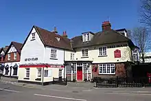 The Seven Stars Public House |
| Sheffield Monument (in churchyard of Parish Church of St John the Evangelist) | Church Avenue, Sidcup | Funerary monument | 1899 | 17 December 1980 | TQ 46493 71545 | 1359407 | .jpg.webp) Sheffield Monument (in churchyard of Parish Church of St John the Evangelist) |
| Sidcup Place (including ha ha to east) | Chislehurst Road, Sidcup | House | 1750 | 14 December 1995 | TQ 46229 71309 | 1117384 | .jpg.webp) Sidcup Place (including ha ha to east) |
| Stable block to former Foots Cray Place | Rectory Lane, Foots Cray | Stable | c. 1756 | 25 August 1954 | TQ 47451 71721 | 1359435 | .jpg.webp) Stable block to former Foots Cray Place |
| Street wall and gateway to north of Red House | Red House Lane, Bexleyheath | Wall | 1859 | 17 December 1980 | TQ 48091 75124 | 1294702 | .jpg.webp) Street wall and gateway to north of Red House |
| Styleman's Almshouses | 13–35 Bexley High Street, Bexley | Houses | 1755 | 1 October 1953 | TQ 49351 73602 | 1064243 | .jpg.webp) Styleman's Almshouses |
| Tomb of Frances Madocks to south side of Parish Church of St James | North Cray Road, North Cray | Tomb | 1790 | 17 December 1980 | TQ 48409 71742 | 1064239 | .jpg.webp) Tomb of Frances Madocks to south side of Parish Church of St James |
| Tudor Cottages | Foots Cray High Street, Foots Cray | Houses | Late 15th or early 16th century | 17 December 1980 | TQ 47422 70917 | 1188354 | 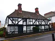 Tudor Cottages |
| Two chest tombs to east side of Parish Church of St James | North Cray Road, North Cray | Tombs | 1728 and 1827 | 17 December 1980 | TQ 48426 71756 | 1188479 | .jpg.webp) Two chest tombs to east side of Parish Church of St James |
| The x-ray department, formerly the Underground Hospital, Erith and District Hospital | Erith | Hospital | 1938 | 27 November 2003 | TQ 50545 77503 | 1393267 | .jpg.webp) The x-ray department, formerly the Underground Hospital, Erith and District Hospital |
| Wall fronting grounds formerly belonging to Bexley House (demolished) | Bourne Road, Crayford | Walls | 18th century | 24 June 1980 | TQ 51028 74766 | 1359382 | .jpg.webp) Wall fronting grounds formerly belonging to Bexley House (demolished) |
| Walls, gatepiers and gates to south of Frognal House | Frognal Avenue, Sidcup | Walls | Early 18th century | 17 December 1980 | TQ 46433 70754 | 1294778 | Walls, gatepiers and gates to south of Frognal House |
| Walls, gate piers and gates to south of stable block at former Foots Cray Place | Rectory Lane, Foots Cray | Walls | 18th century | 17 December 1980 | TQ 47434 71650 | 1064201 | 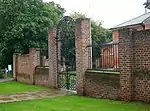 Walls, gate piers and gates to south of stable block at former Foots Cray Place |
| Walls surrounding and to west and south west of Parish Church of St James and gatepiers and gates to west of church | North Cray Road, North Cray | Walls | Mid-18th century | 17 December 1980 | TQ 48385 71759 | 1359414 |  Walls surrounding and to west and south west of Parish Church of St James and gatepiers and gates to west of church |
| Walnut Tree Cottage | 164 Sidcup Hill, Foots Cray | House | Early 17th century | 13 October 1986 | TQ 47230 71071 | 1064212 | .jpg.webp) Walnut Tree Cottage |
| Whitehill House | 1 Crayford Road, Crayford | House | Late 18th–early 19th century | 20 May 1952 | TQ 52336 74483 | 1064224 | 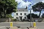 Whitehill House |
| Workshop range to south east of Main Engine House | Belvedere Road, Belvedere | Industrial building | May 1865 | 3 January 1990 | TQ 48528 81013 | 1064216 | .jpg.webp) Workshop range to south east of Main Engine House |
| Workshop range to south west of Main Engine House | Belvedere Road, Belvedere | Industrial building | May 1865 | 3 January 1990 | TQ 48423 81072 | 1250557 | Workshop range to south west of Main Engine House |
| World War II heavy anti-aircraft (HAA) battery | Wallhouse Road, Slade Green | Battery | Late 1930s | 2 December 2009 | TQ 52978 77464 | 1393580 | 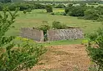 World War II heavy anti-aircraft (HAA) battery |
| Wye Lodge | 80 Lion Road, Bexleyheath | House | 17th century | 17 December 1980 | TQ 48505 74932 | 1064231 | .jpg.webp) Wye Lodge |
.jpg.webp)

.jpg.webp)
.jpg.webp)
Parks and gardens
| Name | Location | Type | Completed [note 1] | Date designated | Grid ref.[note 2] Geo-coordinates |
Entry number [note 3] | Image |
|---|---|---|---|---|---|---|---|
| Danson Park | Danson Road, Bexleyheath | Park and garden | 18th century | 1 October 1987 | TQ4710575029 | 1000211 | |
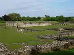
| Foots Cray Place | Foots Cray Meadows, North Cray Road, Sidcup | Park and garden | Mid-18th century | 27 September 1988 | TQ4740971818 | 1000288 | |
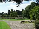
| Hall Place | Bourne Road, Bexley | Park and garden | Early 20th century | 1 October 1987 | TQ 50240 74176 | 1000247 | |
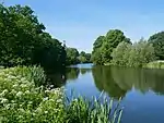
| Lamorbey Park[note 6] | Burnt Oak Lane, Sidcup | Park and garden | Mid-18th century | 7 December 1988 | TQ4669873240 | 1000289 |
.jpg.webp)
.jpg.webp)
See also
Notes
- 1 2 The date given is the date used by Historic England as significant for the initial building or that of an important part in the structure's description.
- 1 2 Sometimes known as OSGB36, the grid reference is based on the British national grid reference system used by the Ordnance Survey.
- 1 2 The "List Entry Number" is a unique number assigned to each listed building and scheduled monument by Historic England.
- ↑ This listing is for Lamorbey House, the mansion on the grounds of the bigger Lamorbey Park.
- ↑ This listing is for Lamorbey House, the mansion on the grounds of the bigger Lamorbey Park.
- ↑ This listing is for Lamorbey Park; the mansion on the grounds, Lamorbey House, is also listed as Lamorbey Park.
- ↑ This listing is for Lamorbey Park; the mansion on the grounds, Lamorbey House, is also listed as Lamorbey Park.
References
- ↑ "Search the List". Historic England. Historic England. Retrieved 19 March 2022.
External links
 Media related to Grade II listed buildings in the London Borough of Bexley at Wikimedia Commons

This article is issued from Wikipedia. The text is licensed under Creative Commons - Attribution - Sharealike. Additional terms may apply for the media files.