
Epsom and Ewell shown within Surrey
There are over 20,000 Grade II* listed buildings in England. This page is a list of the 17 Grade II listed buildings in the district of Epsom and Ewell in Surrey. For links to similar articles in relation to the other 10 districts of Surrey see Grade II* listed buildings in Surrey.
| Name | Location | Type | Completed [note 1] | Date designated | Grid ref.[note 2] Geo-coordinates |
Entry number [note 3] | Image |
|---|---|---|---|---|---|---|---|
| Ashley House | Epsom | House | Dated 1769 | 10 April 1954 | TQ2081160675 51°19′56″N 0°16′02″W / 51.332345°N 0.267261°W |
1289636 |  Upload Photo |
| Christ Church | Epsom Common | Church | 1876 | 22 March 1974 | TQ1954660880 51°20′04″N 0°17′07″W / 51.334455°N 0.285342°W |
1289540 | .JPG.webp) Christ Church |
| Curved Colonnades, Entrance Steps, Outer Pavilions of Woodcote Park (old House), Woodcote Park | Woodcote Park | House | Underway in 1753 | 10 April 1954 | TQ2028958769 51°18′55″N 0°16′31″W / 51.315325°N 0.275393°W |
1288718 | 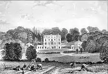 Curved Colonnades, Entrance Steps, Outer Pavilions of Woodcote Park (old House), Woodcote Park |
| Ebbisham House | Epsom | Early 18th century | 10 April 1954 | TQ2133360425 51°19′48″N 0°15′35″W / 51.329987°N 0.259857°W |
1378229 | 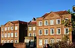 Ebbisham House | |
| Forecourt Rails to Hylands House & Hylands House | Epsom | House | c. 1740 | 10 April 1954 | TQ2022659907 51°19′32″N 0°16′33″W / 51.325566°N 0.275913°W |
1044740 | Upload Photo |
| Garden Wall to Green Anne House, Queen Anne House & Woodcote End House | Epsom and Ewell | House | Late C17-early 18th century | 10 April 1954 | TQ2067759971 51°19′34″N 0°16′10″W / 51.326046°N 0.269422°W |
1288644 | Upload Photo |
| The Durdans | Epsom and Ewell | House | 1764 | 10 January 1974 | TQ2078059452 51°19′17″N 0°16′05″W / 51.32136°N 0.26812°W |
1378221 | _(geograph_2742725).jpg.webp) The Durdans |
| Gates to the Durdans on Chalk Lane | Epsom and Ewell | Gate | Early 18th century | 10 April 1954 | TQ2089659517 51°19′19″N 0°15′59″W / 51.321919°N 0.266434°W |
1378222 | .jpg.webp) Gates to the Durdans on Chalk Lane |
| Riding School at the Durdans | Epsom and Ewell | Riding School | 1881 | 10 January 1974 | TQ2085759581 51°19′21″N 0°16′01″W / 51.322503°N 0.266972°W |
1378224 | .jpg.webp) Riding School at the Durdans |
| Nonsuch Park House | Nonsuch Park | Country House | 1802-1806 | 10 April 1954 | TQ2342663611 51°21′29″N 0°13′43″W / 51.358171°N 0.228728°W |
1378198 | |
| Parish Church of St Martin | Epsom and Ewell | Parish Church | c. 1450 | 10 April 1954 | TQ2139560522 51°19′51″N 0°15′32″W / 51.330846°N 0.258935°W |
1028592 |  Parish Church of St Martin |
| The Cedars | Epsom | House | late C17-early 18th century | 10 April 1954 | TQ2121660598 51°19′54″N 0°15′41″W / 51.331567°N 0.261477°W |
1378227 | Upload Photo |
| The Hylands, Including Forecourt Walls, Piers, Clairvoyee and Gates | Epsom and Ewell | House | Mid 18th century | 10 April 1954 | TQ2025259943 51°19′33″N 0°16′32″W / 51.325885°N 0.275528°W |
1044739 | Upload Photo |
| Woodcote Green House | Epsom and Ewell | House | Late 17th century | 10 April 1954 | TQ2066759851 51°19′30″N 0°16′11″W / 51.32497°N 0.269606°W |
1214289 | Upload Photo |
| Woodcote Grove | Epsom and Ewell | House | Late 17th century | 10 April 1954 | TQ2083059762 51°19′27″N 0°16′02″W / 51.324135°N 0.267298°W |
1028576 | 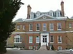 Woodcote Grove |
| 149–153 High Street | Epsom and Ewell | Tenement House | C20 | 10 April 1954 | TQ2062460705 51°19′58″N 0°16′12″W / 51.332654°N 0.269934°W |
1213183 |  149–153 High Street |
| 127 and 129 High Street | Epsom and Ewell | House | Late 18th century | 10 April 1954 | TQ2070860725 51°19′58″N 0°16′07″W / 51.332816°N 0.268722°W |
1213163 | Upload Photo |

Notes
- ↑ The date given is the date used by Historic England as significant for the initial building or that of an important part in the structure's description.
- ↑ Sometimes known as OSGB36, the grid reference is based on the British national grid reference system used by the Ordnance Survey.
- ↑ The "List Entry Number" is a unique number assigned to each listed building and scheduled monument by Historic England.
References
This article is issued from Wikipedia. The text is licensed under Creative Commons - Attribution - Sharealike. Additional terms may apply for the media files.