Göynük District | |
|---|---|
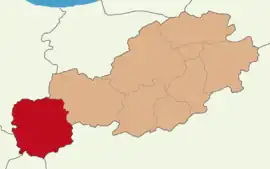 Map showing Göynük District in Bolu Province | |
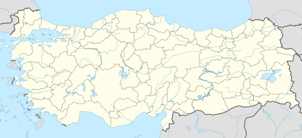 Göynük District Location in Turkey | |
| Coordinates: 40°24′N 30°47′E / 40.400°N 30.783°E | |
| Country | Turkey |
| Province | Bolu |
| Seat | Göynük |
| Government | |
| • Kaymakam | Ferhat Gür |
| Area | 1,407 km2 (543 sq mi) |
| Population (2021) | 14,679 |
| • Density | 10/km2 (27/sq mi) |
| Time zone | TRT (UTC+3) |
| Website | www |
Göynük District is a district of the Bolu Province of Turkey. Its seat is the town of Göynük.[1] Its area is 1,407 km2,[2] and its population is 14,679 (2021).[3]
Composition
There is one municipality in Göynük District:[1]
There are 66 villages in Göynük District:[4]
- Ahmetbeyler
- Akçaalan
- Aksaklar
- Alanköy
- Arıkçayırı
- Arızlar
- Aşağıkınık
- Bayındır
- Bekirfakılar
- Bölücekova
- Boyacılar
- Bozcaarmut
- Bulanık
- Çamlıca
- Çapar
- Çatacık
- Çayköy
- Çaylakköy
- Ceylanlı
- Çubukköy
- Dağhacılar
- Dağşeyhleri
- Dedeler
- Değirmenözü
- Demirhanlar
- Ekinciler
- Gerişler
- Gökçesaray
- Güneyçalıca
- Gürpınar
- Hacımahmut
- Hasanlar
- Hilaller
- Himmetoğlu
- Hisarözü
- İbrahimözü
- Karaaliler
- Karaardıç
- Karacalar
- Kaşıkçışeyhler
- Kayabaşı
- Kayalıdere
- Kılavuzlar
- Kilciler
- Kızılkuyu
- Köybaşı
- Kozcağız
- Kumcuk
- Kürnüç
- Kuyupınar
- Memeceler
- Mustanlar
- Narzanlar
- Örencik
- Pelitcik
- Sarıcalar
- Sarılar
- Soğukçam
- Sünnet
- Susuz
- Tekirler
- Tepebaşı
- Umurlar
- Yeniköy
- Yeşilyazı
- Yukarıkınık
References
- 1 2 İlçe Belediyesi, Turkey Civil Administration Departments Inventory. Retrieved 30 January 2023.
- ↑ "İl ve İlçe Yüz ölçümleri". General Directorate of Mapping. Retrieved 30 January 2023.
- ↑ "Address-based population registration system (ADNKS) results dated 31 December 2021" (XLS) (in Turkish). TÜİK. Retrieved 30 January 2023.
- ↑ Köy, Turkey Civil Administration Departments Inventory. Retrieved 30 January 2023.
Göynük District in Bolu Province of Turkey | |||||||||||||||||||||||||||
|---|---|---|---|---|---|---|---|---|---|---|---|---|---|---|---|---|---|---|---|---|---|---|---|---|---|---|---|
| Districts | 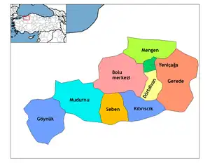 Districts of Bolu | ||||||||||||||||||||||||||
| |||||||||||||||||||||||||||
Metropolitan municipalities are bolded. | |||||||||||||||||||||||||||
This article is issued from Wikipedia. The text is licensed under Creative Commons - Attribution - Sharealike. Additional terms may apply for the media files.