Gänserndorf District
Bezirk Gänserndorf | |
|---|---|
| Country | Austria |
| State | Lower Austria |
| Number of municipalities | 44 |
| Area | |
| • Total | 1,272 km2 (491 sq mi) |
| Population (2016) | |
| • Total | 99,738[1] |
| Time zone | UTC+01:00 (CET) |
| • Summer (DST) | UTC+02:00 (CEST) |
| Telephone prefix | 2247 |
| NUTS code | AT125 |
Bezirk Gänserndorf (German pronunciation: [ˈɡɛnzɐnˌdɔʁf] ⓘ) is a district of the state of Lower Austria in Austria. The Marchfeld lies in it.
Municipalities

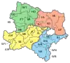
Municipalities of Gänserndorf District
Towns (Städte) are indicated in boldface; market towns (Marktgemeinden) in italics; suburbs, hamlets and other subdivisions of a municipality are indicated in small characters.[2]
- Aderklaa
- Andlersdorf
- Angern an der March
- Angern an der March, Grub an der March, Mannersdorf an der March, Ollersdorf, Stillfried
- Auersthal
- Bad Pirawarth
- Bad Pirawarth, Kollnbrunn
- Deutsch-Wagram
- Drösing
- Drösing, Waltersdorf an der March
- Dürnkrut
- Dürnkrut, Waidendorf
- Ebenthal
- Eckartsau
- Eckartsau, Kopfstetten, Pframa, Wagram an der Donau, Witzelsdorf
- Engelhartstetten
- Engelhartstetten, Groißenbrunn, Loimersdorf, Markthof, Schloßhof, Stopfenreuth
- Gänserndorf
- Glinzendorf
- Groß-Enzersdorf
- Franzensdorf, Groß-Enzersdorf, Matzneusiedl, Mühlleiten, Oberhausen, Probstdorf, Rutzendorf, Schönau an der Donau, Wittau
- Groß-Schweinbarth
- Großhofen
- Haringsee
- Fuchsenbigl, Haringsee, Straudorf
- Hauskirchen
- Hauskirchen, Prinzendorf an der Zaya, Rannersdorf an der Zaya
- Hohenau an der March
- Hohenruppersdorf
- Jedenspeigen
- Jedenspeigen, Sierndorf an der March
- Lassee
- Lassee, Schönfeld im Marchfeld
- Leopoldsdorf im Marchfelde
- Breitstetten, Leopoldsdorf im Marchfelde
- Mannsdorf an der Donau
- Marchegg
- Breitensee, Marchegg
- Markgrafneusiedl
- Matzen-Raggendorf
- Klein-Harras, Matzen, Raggendorf
- Neusiedl an der Zaya
- Neusiedl an der Zaya, St. Ulrich
- Obersiebenbrunn
- Orth an der Donau
- Palterndorf-Dobermannsdorf
- Dobermannsdorf, Palterndorf
- Parbasdorf
- Prottes
- Raasdorf
- Pysdorf, Raasdorf
- Ringelsdorf-Niederabsdorf
- Niederabsdorf, Ringelsdorf
- Schönkirchen-Reyersdorf
- Reyersdorf, Schönkirchen
- Spannberg
- Strasshof an der Nordbahn
- Sulz im Weinviertel
- Erdpreß, Nexing, Niedersulz, Obersulz
- Untersiebenbrunn
- Velm-Götzendorf
- Götzendorf, Velm
- Weiden an der March
- Baumgarten an der March, Oberweiden, Zwerndorf
- Weikendorf
- Dörfles, Stripfing, Tallesbrunn, Weikendorf
- Zistersdorf
- Blumenthal, Eichhorn, Gaiselberg, Gösting, Großinzersdorf, Loidesthal, Maustrenk, Windisch, Baumgarten, Zistersdorf
References
- ↑ "Statistische Daten". noel.gv.at (in German). Archived from the original on 30 June 2017. Retrieved 18 May 2023.
- ↑ "BH Gänserndorf - Land Niederösterreich". www.noel.gv.at. Retrieved 18 May 2023.
External links
Wikimedia Commons has media related to Gänserndorf District.
This article is issued from Wikipedia. The text is licensed under Creative Commons - Attribution - Sharealike. Additional terms may apply for the media files.