Elwood Township | |
|---|---|
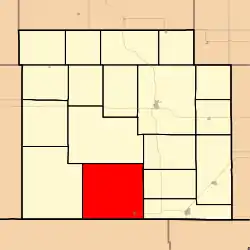 Location in Barber County | |
| Coordinates: 37°03′42″N 098°41′21″W / 37.06167°N 98.68917°W | |
| Country | United States |
| State | Kansas |
| County | Barber |
| Area | |
| • Total | 100.38 sq mi (259.99 km2) |
| • Land | 100.2 sq mi (259.53 km2) |
| • Water | 0.18 sq mi (0.46 km2) 0.18% |
| Elevation | 1,519 ft (463 m) |
| Population (2000) | |
| • Total | 275 |
| • Density | 2.7/sq mi (1.1/km2) |
| GNIS feature ID | 0470533 |
Elwood Township is a township in Barber County, Kansas, USA. As of the 2000 census, its population was 275.
Geography
Elwood Township covers an area of 100.38 square miles (260.0 km2) and contains one incorporated settlement, Hardtner.
Cook Lake is within this township. The stream of Dry Creek runs through this township.
References
External links
Municipalities and communities of Barber County, Kansas, United States | ||
|---|---|---|
| Cities | 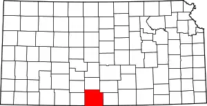 Map of Kansas highlighting Barber County | |
| Unincorporated communities | ||
| Townships | ||
| Footnotes | †This community is designated a Census-Designated Place (CDP) by the United States Census Bureau. | |
This article is issued from Wikipedia. The text is licensed under Creative Commons - Attribution - Sharealike. Additional terms may apply for the media files.