Dar Agah Rural District
Persian: دهستان درآگاه | |
|---|---|
 Dar Agah Rural District | |
| Coordinates: 28°32′29″N 55°39′44″E / 28.54139°N 55.66222°E[1] | |
| Country | |
| Province | Hormozgan |
| County | Hajjiabad |
| District | Central |
| Capital | Dehestan-e Bala |
| Population (2016)[2] | |
| • Total | 6,382 |
| Time zone | UTC+3:30 (IRST) |
Dar Agah Rural District (Persian: دهستان درآگاه) is in the Central District of Hajjiabad County, Hormozgan province, Iran. Its capital is the village of Dehestan-e Bala.
At the National Census of 2006, its population was 7,512 in 1,862 households.[3] There were 6,274 inhabitants in 1,788 households at the following census of 2011.[4] At the most recent census of 2016, the population of the rural district was 6,382 in 1,930 households. The largest of its 80 villages was Baghat, with 1,347 people.[2]
References
- ↑ OpenStreetMap contributors (8 September 2023). "Dar Agah Rural District (Hajjiabad County)" (Map). OpenStreetMap. Retrieved 8 September 2023.
- 1 2 "Census of the Islamic Republic of Iran, 1395 (2016)". AMAR (in Persian). The Statistical Center of Iran. p. 22. Archived from the original (Excel) on 5 May 2022. Retrieved 19 December 2022.
- ↑ "Census of the Islamic Republic of Iran, 1385 (2006)". AMAR (in Persian). The Statistical Center of Iran. p. 22. Archived from the original (Excel) on 20 September 2011. Retrieved 25 September 2022.
- ↑ "Census of the Islamic Republic of Iran, 1390 (2011)" (Excel). Iran Data Portal (in Persian). The Statistical Center of Iran. p. 22. Retrieved 19 December 2022.
Hormozgan Province, Iran | |||||||||||||||||||||||||
|---|---|---|---|---|---|---|---|---|---|---|---|---|---|---|---|---|---|---|---|---|---|---|---|---|---|
| Capital | 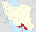 | ||||||||||||||||||||||||
| Counties and cities |
| ||||||||||||||||||||||||
| Sights |
| ||||||||||||||||||||||||
| populated places | |||||||||||||||||||||||||
| See also | |||||||||||||||||||||||||
This article is issued from Wikipedia. The text is licensed under Creative Commons - Attribution - Sharealike. Additional terms may apply for the media files.