Cianjur Regency
Kabupaten Cianjur | |
|---|---|
| Other transcription(s) | |
| • Sundanese | ᮊᮘᮥᮕᮒᮨᮔ᮪ ᮎᮤᮃᮔ᮪ᮏᮥᮁ |
 Flag  Coat of arms | |
| Motto(s): Sugih Mukti ᮞᮥᮌᮤᮂ ᮙᮥᮊ᮪ᮒᮤ Wealthy Joyous | |
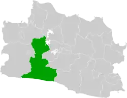 Location within West Java | |
| Coordinates: 6°49′16″S 107°08′24″E / 6.8212°S 107.1400°E | |
| Country | Indonesia |
| Province | West Java |
| Government | |
| • Regent | Herman Suherman |
| • Vice Regent | Tubagus Mulyana Syahrudin |
| Area | |
| • Total | 3,614.35 km2 (1,395.51 sq mi) |
| Population (mid 2022 estimate) | |
| • Total | 2,542,793 |
| [1] | |
| Time zone | UTC+7 (IWST) |
| Area code | (+62) 263 |
| Website | cianjurkab.go.id |
Cianjur Regency is a regency (kabupaten) of West Java, Indonesia. The area of the regency is 3,614.35 km2 and its population at the 2010 Census was 2,171,281;[2] the 2020 Census produced a total of 2,477,560[3] and the official estimate as at mid 2022 was 2,542,793.[1] The district of Cianjur is its seat. Northern parts of the regency form a valley (above the 'neck'), and are far more densely populated than southern regions. As such, a portion of the northern valley (consisting of Cugenang, Pacet, Sukaresmi and Cipanas districts in the far northwest of the regency) was briefly included in a definition of Greater Jakarta called Jabodetabekjur (jur for Cianjur).
Administrative divisions
Cianjur Regency is divided into thirty-two districts (kecamatan), listed below with their areas and their populations at the 2010 and 2020 Censuses,[2][3] together with the official estimates as at mid 2022.[1] The table also includes the locations of the district administrative centres, the number of villages in each district (totaling 354 rural desa and 6 urban kelurahan), and its post code.
(A) Districts south of the "neck"
| Kode Wilayah | Name of District (kecamatan) | Area in km2 | Pop'n 2010 Census | Pop'n 2020 Census | Pop'n mid 2022 Estimate | Admin centre | No. of villages | Post code |
|---|---|---|---|---|---|---|---|---|
| 32.03.22 | Agrabinta | 192.65 | 36,758 | 40,544 | 41,323 | Mekasari | 11 | 43276 |
| 32.03.30 | Leles | 114.32 | 31,931 | 31,595 | 31,730 | Pusakasari | 12 | 43273 |
| 32.03.21 | Sindangbarang | 159.08 | 51,777 | 58,508 | 59,912 | Saganten | 11 | 43272 |
| 32.03.23 | Cidaun | 295.51 | 64,181 | 69,548 | 70,642 | Kertajadi | 14 | 43275 |
| 32.03.24 | Naringgul | 281.32 | 44,665 | 47,470 | 48,036 | Wangunjaya | 11 | 43274 |
| 32.03.20 | Cibinong | 235.48 | 57,842 | 64,164 | 65,469 | Sukajadi | 14 | 43271 |
| 32.03.26 | Cikadu | 188.66 | 34,654 | 37,028 | 37,508 | Cikadu | 10 | 43286 |
| 32.03.19 | Tanggeung | 59.80 | 44,288 | 50,165 | 51,393 | Tanggeung | 12 | 43267 |
| 32.03.32 | Pasirkuda | 115.15 | 34,513 | 38,149 | 38,898 | Kalibaru | 9 | 43266 & 43267 |
| 32.03.17 | Kadupandak | 104.41 | 48,768 | 52,941 | 53,792 | Kadupandak | 14 | 43268 |
| 32.03.29 | Cijati | 49.02 | 32,737 | 34,452 | 34,796 | Cijati | 10 | 43284 |
| 32.03.16 | Takokak | 142.16 | 50,883 | 52,072 | 52,308 | Pasawahan | 9 | 43265 |
| 32.03.14 | Sukanagara | 174.05 | 48,727 | 55,730 | 57,201 | Sukanagara | 10 | 43264 |
| 32.03.18 | Pagelaran | 199.44 | 68,121 | 75,668 | 77,227 | Pagelaran | 14 | 43266 |
| 32.03.15 | Campaka | 143.75 | 63,847 | 69,727 | 70,930 | Cidadep | 11 | 43263 |
| 32.03.25 | Campaka Mulya | 74.28 | 23,756 | 24,020 | 24,073 | Campakamulya | 5 | 43269 |
| Totals | 2,529.08 | 737,448 | 801,781 | 815,238 | 177 |
(B) Districts north of the "neck"
| Kode Wilayah | Name of District (kecamatan) | Area in km2 | Pop'n 2010 Census | Pop'n 2020 Census | Pop'n mid 2022 Estimate | Admin centre | No. of villages | Post code |
|---|---|---|---|---|---|---|---|---|
| 32.03.03 | Cibeber | 124.73 | 115,907 | 133,786 | 137.561 | Cihaur | 18 | 43262 |
| 32.03.02 | Warungkondang | 45.16 | 64,880 | 77,749 | 80,525 | Jambudipa | 11 | 43260 |
| 32.03.27 | Gekbrong | 50.77 | 51,026 | 60,919 | 63,048 | Gekbrong | 8 | 43261 |
| 32.03.04 | Cilaku | 52.53 | 96,823 | 117,658 | 122,188 | Sukasari | 10 | 43285 |
| 32.03.09 | Sukaluyu | 48.02 | 70,082 | 89,538 | 93,892 | Sukaluyu | 10 | 43287 |
| 32.03.06 | Bojongpicung | 88.34 | 70,959 | 83,446 | 86,111 | Bojongpicung | 11 | 43283 |
| 32.03.31 | Haurwangi | 46.18 | 53,641 | 63,813 | 65,998 | Kertasari | 8 | 43280 |
| 32.03.05 | Ciranjang | 34.81 | 74,439 | 88,754 | 91,833 | Cibiuk | 9 | 43282 |
| 32.03.08 | Mande | 98.79 | 69,148 | 81,567 | 84,222 | Mulyasari | 12 | 43292 |
| 32.03.07 | Karangtengah | 48.53 | 134,318 | 164,367 | 170,927 | Hegarmanah | 16 | 43281 |
| 32.03.01 | Cianjur (town) | 26.15 | 158,125 | 173,265 | 176,368 | Pamoyanan | 11 | 43215 & 43216 |
| 32.03.11 | Cugenang (a) | 76.15 | 99,539 | 117,211 | 120,961 | Mangunkerta | 16 | 43252 |
| 32.03.10 | Pacet (a) | 41.66 | 96,664 | 110,970 | 113,981 | Cipendawa | 7 | 43253 (b) |
| 32.03.28 | Cipanas (a) | 67.28 | 103,911 | 113,592 | 115,574 | Cipanas | 7 | 43253 |
| 32.03.13 | Sukaresmi (a) | 92.15 | 80,009 | 91,342 | 93,720 | Cikanyere | 11 | 43254 |
| 32.03.12 | Cikalongkulon | 144.02 | 94,262 | 107,802 | 110,646 | Sukagalih | 18 | 43291 |
| Totals | 1,085.27 | 1,433,733 | 1,675,779 | 1,727,555 | 183 |
Notes: (a) these 4 districts for a while formed part of the defined metropolitan district of Jabodetabekjur. (b) except the village of Ciputri, which has a post code of 43281.
Of the 360 villages, 354 are rural desa, while 6 are urban kelurahan (Bojongherang, Muka, Pamoyanan, Sawah Gede, Sayang and Solokpandan), which are all part of Cianjur (town) District (kecamatan).
Tourism
Mount Padang
A terracing structure, although local people mention it as a pyramid, lies on Mount Padang, 31 kilometer from Cianjur through Warung Kondang. It is the biggest Megalithic Site in Southeast Asia.[4]
References
- 1 2 3 Badan Pusat Statistik, Jakarta, 2023, Kabupaten Cianjur Dalam Angka 2023 (Katalog-BPS 1102001.3203)
- 1 2 Biro Pusat Statistik, Jakarta, 2011.
- 1 2 Badan Pusat Statistik, Jakarta, 2021.
- ↑ "Megahnya Situs Megalith Gunung Padang Cianjur". Archived from the original on January 3, 2012. Retrieved February 9, 2012.
Places adjacent to Cianjur Regency | |
|---|---|