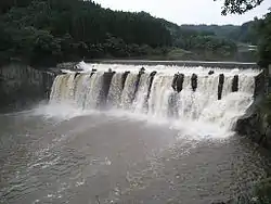
Chinda Falls (沈堕の滝, Chinda no taki) is a double waterfall on the Ōno River in Bungo-ōno, Ōita Prefecture, Japan.
Waterfalls
The Chinda Falls comprise Odaki Falls (雄滝), with a height of 17 m and width of 93 m, and Medaki Falls (雌滝), with a height of 18 m and width of 4 m.[1] Known locally as the "Niagara of the Ōno", they are the central feature of Takimi Park (滝見公園).[1]
History
As early as the fifteenth century the falls provided a subject for ink wash painting and they feature in the 1803 Chorography of Bungo (豊後国志).[2] In 1909 a dam was built immediately upstream to provide hydroelectric power; in 1923 the height of the dam was raised to increase capacity.[2] The waterfall was subsequently reduced by rock collapses during flooding.[3] In the 1990s, with the dam itself at risk, reinforcement work was carried out by Kyushu Electric Power Company, as well as ancillary landscaping.[3][4] In 2007 Chinda Falls was registered as a Place of Scenic Beauty.[5]
Depictions
_by_Kano_Tsunenobu_(after_Sesshu).png.webp)
Sesshū was inspired by the waterfall to paint Chinda Falls (鎮田瀑図). Although this work was destroyed in the Great Kantō earthquake, a copy by Kanō Tsunenobu survives at the Kyoto National Museum.[6][7] As part of the efforts to revitalise the area through promotion of its heritage, in late October each year, at the end of the rice harvest, a Sesshū Festival is staged.[1]
See also
References
- 1 2 3 "沈堕の滝" [Chinda Falls] (PDF) (in Japanese). Ōita Prefecture. Retrieved 21 May 2012.
- 1 2 "沈堕の滝" [Chinda Falls] (in Japanese). Agency for Cultural Affairs. Archived from the original on 18 December 2012. Retrieved 21 May 2012.
- 1 2 "Landscape and Cultural Heritage: Chinda Power Plant, Japan" (PDF). IEA Hydropower. Archived from the original (PDF) on 20 March 2012. Retrieved 21 May 2012.
- ↑ "登録記念物>沈堕の滝" [Registered Monuments: Chinda Falls] (in Japanese). Bungo-ōno City. Archived from the original on 20 July 2012. Retrieved 21 May 2012.
- ↑ "沈堕の滝" [Chinda Falls] (in Japanese). Agency for Cultural Affairs. Retrieved 21 May 2012.
- ↑ "鎮田瀑図" [Chinda Falls] (in Japanese). Kyoto National Museum. Retrieved 21 May 2012.
- ↑ "九州水物語=沈堕の滝" [Aquatic Heritage of Kyushu: Chinda Falls]. Nishinippon Shimbun (in Japanese). 24 February 2006. Retrieved 21 May 2012.