Charlton Heights, West Virginia | |
|---|---|
Census-designated place (CDP) | |
 Charlton Heights  Charlton Heights | |
| Coordinates: 38°07′25″N 81°14′02″W / 38.12361°N 81.23389°W | |
| Country | United States |
| State | West Virginia |
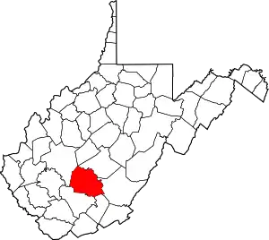
| County | Fayette |
| Area | |
| • Total | 0.489 sq mi (1.27 km2) |
| • Land | 0.414 sq mi (1.07 km2) |
| • Water | 0.075 sq mi (0.19 km2) |
| Elevation | 663 ft (202 m) |
| Population | |
| • Total | 406 |
| • Density | 830/sq mi (320/km2) |
| Time zone | UTC-5 (Eastern (EST)) |
| • Summer (DST) | UTC-4 (EDT) |
| ZIP code | 25040 |
| Area code(s) | 304 & 681 |
| GNIS feature ID | 1537222[3] |
Charlton Heights is a census-designated place (CDP) in Fayette County, West Virginia, United States. Charlton Heights is located on the north bank of the Kanawha River, 4 miles (6.4 km) southwest of Gauley Bridge. Charlton Heights has a post office with ZIP code 25040.[4] As of the 2010 census, its population was 406.[2]
References
- ↑ "US Gazetteer files: 2010, 2000, and 1990". United States Census Bureau. February 12, 2011. Retrieved April 23, 2011.
- 1 2 "U.S. Census website". United States Census Bureau. Retrieved May 14, 2011.
- ↑ U.S. Geological Survey Geographic Names Information System: Charlton Heights, West Virginia
- ↑ ZIP Code Lookup Archived June 14, 2011, at the Wayback Machine
This article is issued from Wikipedia. The text is licensed under Creative Commons - Attribution - Sharealike. Additional terms may apply for the media files.