Breuville | |
|---|---|
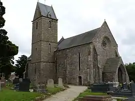 The church of Saint-Pierre | |
.svg.png.webp) Coat of arms | |
Location of Breuville | |
 Breuville  Breuville | |
| Coordinates: 49°32′13″N 1°40′17″W / 49.5369°N 1.6714°W | |
| Country | France |
| Region | Normandy |
| Department | Manche |
| Arrondissement | Cherbourg |
| Canton | Bricquebec-en-Cotentin |
| Intercommunality | CA Cotentin |
| Government | |
| • Mayor (2020–2026) | Jean-Pierre Poignant[1] |
| Area 1 | 8.41 km2 (3.25 sq mi) |
| Population | 401 |
| • Density | 48/km2 (120/sq mi) |
| Time zone | UTC+01:00 (CET) |
| • Summer (DST) | UTC+02:00 (CEST) |
| INSEE/Postal code | 50079 /50260 |
| Elevation | 58–138 m (190–453 ft) (avg. 132 m or 433 ft) |
| 1 French Land Register data, which excludes lakes, ponds, glaciers > 1 km2 (0.386 sq mi or 247 acres) and river estuaries. | |
Breuville (French pronunciation: [bʁøvil]) is a commune in the Manche department in Normandy in northwestern France.
Population
| Year | Pop. | ±% p.a. |
|---|---|---|
| 1968 | 238 | — |
| 1975 | 221 | −1.05% |
| 1982 | 292 | +4.06% |
| 1990 | 361 | +2.69% |
| 1999 | 351 | −0.31% |
| 2009 | 381 | +0.82% |
| 2014 | 408 | +1.38% |
| 2020 | 402 | −0.25% |
| Source: INSEE[3] | ||
The inhabitants are called Breuvillais in French.
See also
References
- ↑ "Répertoire national des élus: les maires". data.gouv.fr, Plateforme ouverte des données publiques françaises (in French). 2 December 2020.
- ↑ "Populations légales 2021". The National Institute of Statistics and Economic Studies. 28 December 2023.
- ↑ Population en historique depuis 1968, INSEE
Wikimedia Commons has media related to Breuville.
This article is issued from Wikipedia. The text is licensed under Creative Commons - Attribution - Sharealike. Additional terms may apply for the media files.