| Blindman River | |
|---|---|
 Blindman River, near Rimbey, Alberta | |
| Location | |
| Country | Canada |
| Province | Alberta |
| Physical characteristics | |
| Source | |
| • location | Medicine Lake Provincial Grazing Reserve |
| • coordinates | 52°53′13″N 114°34′39″W / 52.88694°N 114.57750°W |
| • elevation | 1,003 m (3,291 ft) |
| Mouth | |
• location | Red Deer River |
• coordinates | 52°21′17″N 113°45′26″W / 52.35472°N 113.75722°W |
• elevation | 859 m (2,818 ft) |
The Blindman River is in south-central Alberta. It forms south of Winfield and flows southeastward before joining the Red Deer River near Red Deer. The Blindman is bridged by Alberta Highway 20 a number of times in its upper reaches, before passing near the town of Rimbey. The river then takes on the outflow of Gull Lake. It is bridged by Alberta Highway 2 at Red Deer before flowing into the Red Deer River.


There are two competing theories regarding the name of the river. One theory suggests a Cree hunting party became snowblind while travelling and had to rest on the river banks until their eyes healed. The hunting party applied the name paskapiw to the river, which translates as 'He is blind'.[1] The second theory argues that Blindman is a descriptive term, applied to the river because of its numerous meanders and curves.[2]
The Paskapoo Formation, first described in its banks, takes its name from the Cree name for the Blindman.
Tributaries
- Anderson Creek
- Lloyd Creek
- Boyd Creek
- Potter Creek
- Gull Lake
See also
References
- ↑ "Search results". www.creedictionary.com. Retrieved 2023-01-11.
- ↑ Tracey Harrison, Place Names of Alberta: Volume III, Central Alberta. (Calgary: University of Calgary Press, 1994), page 28.
| Rivers | 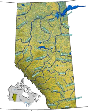 Rivers and lakes in Alberta | |
|---|---|---|
| Waterfalls | ||
| Lakes | ||
| Reservoirs | ||
| Glaciers | ||
| Other | ||