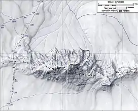
Map of Mount Toney
Williamson Ridge (75°47′S 116°45′W / 75.783°S 116.750°W) is a low snow-covered ridge, 10 nautical miles (18 km) long and 2 to 5 nautical miles (9 km) wide, that forms a western extension of Toney Mountain in Marie Byrd Land. It was mapped by United States Geological Survey (USGS) from ground surveys and U.S. Navy air photos, 1959–71. Named by Advisory Committee on Antarctic Names (US-ACAN) for Paul R. Williamson, ionospheric physicist at Byrd Station in two austral summers, 1967–68 and 1969–70.
References
External links
![]() This article incorporates public domain material from "Williamson Ridge". Geographic Names Information System. United States Geological Survey.
This article incorporates public domain material from "Williamson Ridge". Geographic Names Information System. United States Geological Survey.
This article is issued from Wikipedia. The text is licensed under Creative Commons - Attribution - Sharealike. Additional terms may apply for the media files.