Vijayamangalam | |
|---|---|
Town | |
 NH47 Toll Plaza at Vijayamangalam On Coimbatore-Salem National highway | |
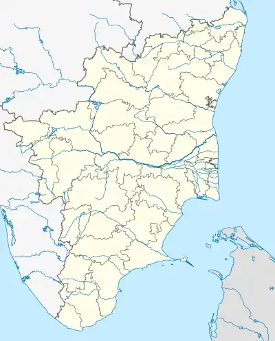 Vijayamangalam Location in Tamil Nadu, India  Vijayamangalam Vijayamangalam (India) | |
| Coordinates: 11°14′N 77°30′E / 11.23°N 77.5°E | |
| Country | |
| State | Tamil Nadu |
| District | Erode |
| Elevation | 303 m (994 ft) |
| Population (2011) | |
| • Total | 6,517 |
| Languages | |
| • Official | Tamil |
| Time zone | UTC+5:30 (IST) |
| PIN | 638056 |
| Vehicle registration | TN-56 |
Vijayamangalam is a census town in Erode district in the Indian state of Tamil Nadu. It is located on National Highway 47 (NH-47) between Perundurai and Perumanallur.
Geography
Vijayapuri (also known as Vijayamangalam) is located at 11°14′N 77°30′E / 11.23°N 77.5°E[1] along NH-47 (bypass). It is the junction point for Tiruppur road and Coimbatore Road towards Salem. New toll plaza on four lane road is located very close to Vijayamangalam on Coimbatore-Salem section. It has an average elevation of 303 metres (994 feet).
It is located 33 km towards west from District headquarters Erode. 12 km from Perundurai. 422 km from State capital Chennai. kaikolapalayam (3 km), Mettupudur ( 1 km ), Kalliampudur (1.5 km), Moongilpalayam ( 1 km ), pagallayur (1.5 Km), Thottipalayam (2.5 km), Kovilpalayam(1km), Ponmudi ( 5 km ), Periyaveerasangili (4 km), Karandipalayam ( 5 km ) are the nearby Villages to Vijayamangalam. Vijayamangalam is surrounded by Uttukkuli Taluk towards South, Chennimalai Taluk towards East, Tiruppur Taluk towards west, Nambiyur Taluk towards north.
Uthukuli, Perumanallur, Tiruppur, Chengapalli, Erode, Gobichettipalayam, Perundurai, Avinashi, Chennimalai, Bhavani are the nearby Cities to Vijayamangalam.
Demographics
As of 2011 India census,[2] Vijayapuri had a population of 6517. As per 2001 census, males constitute 52% of the population and females 48%. Vijayapuri has an average literacy rate of 68%, higher than the national average of 59.5%: male literacy is 76%, and female literacy is 59%. In Vijayapuri, 10% of the population is under 6 years of age.
How To Reach
Vijyamangalam is well connected with Roadways and Railways.
Salem To Ernakulam Highway (NH-47) passes through this town. So, this Town is well connected by Roadways. The town connects Salem, Erode, Perundurai, Avinashi, Kangayam, Bhavani, Coimbatore, Nasiyanur, Chengapalli, Chennimalai, Ingur, Perumanallur and Tirupur by roadways.
Vijayamangalam Railway Station (VZ), Uthukuli Railway Station, Perundurai Railway Station are the very nearby railway stations to Vijayamangalam. However Erode Junction railway station is the major railway station 30 km near to Vijayamangalam ; Tiruppur railway station is 25 km away.
Temples
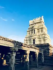
- Vijayamangalam Jain temple: This town was an ancient settlement of Jains.[3] Vijayamangalam Jain temple was built in c. 678 C.E. by King Konguvelir.[4][5] This temple is dedicated to Chandraprabha, the eighth Tirthankara of Jainism.[6]
- Sri Nageswaraswamy Shiva Temple
- Sri Karivaradharaja Perumal Temple
- Sri Vijayapuri Amman Temple
- Arasanna Malai Agneeshwarar and Arasathal Temple (Kongampalayam) - on every fullmoon day, 3000 people attend girivalam
- Sri Ranganayaki Amman temple
Loom City
The major occupations around Vijayamangalam and surrounding areas are weaving and agriculture. A lot of handlooms, power looms and automatic looms are seen running as small and medium-sized business around this area. The textiles are sold in Kerala, Andhra Pradesh and North India. The major market of the produced textiles are sold in Erode city textile market called Gani Textile Market
Vintex is one of the foremost co-operative companies formed by the weaving community which has been regarded as the sole propeller of uplift of this area's people. Agriculture was the main source of income during independence but weaving turned this area together. Vintex is seen as an industrial revolution for this area. It made a lot of people to think of weaving as a source of income next to agriculture.
Educationl Institutions near Vijayamangalam
Colleges
- Sasurie College of Engineering
- Kongu Engineering College
- Institute of Road & Transport Technology
- IRT Perundurai Medical College
- EICT Polytechnic College
- Sri Ramanathan College of Engineering
Schools
- Roots Matriculation School
- Bharathi Matriculation Higher Secondary School
- Vijay Vikas International School
References
- ↑ Falling Rain Genomics, Inc - Vijayapuri
- ↑ "Census of India 2001: Data from the 2001 Census, including cities, villages and towns (Provisional)". Census Commission of India. Archived from the original on 16 June 2004. Retrieved 1 November 2008.
- ↑ Sundaram, B Meenakshi (30 August 2015). "Kottravai, the Tamil Goddess of Victory". The New Indian Express. Retrieved 25 January 2021.
- ↑ Home Ministry (2011). "District census handbook Erode" (PDF). Census. p. 110. Retrieved 7 April 2022.
- ↑ Krishnamachari, Suganthy (12 October 2017). "On how Kongu Nadu was a Jain bastion". The Hindu. ISSN 0971-751X. Retrieved 25 January 2021.
- ↑ Umamaheshwari, R. (2018). Reading History with the Tamil Jainas: A Study on Identity, Memory and Marginalisation. Sophia Studies in Cross-cultural Philosophy of Traditions and Cultures. Vol. 2. Springer. p. 308. ISBN 9788132237563.