Chimbu Province
Simbu Province | |
|---|---|
 Flag | |
 | |
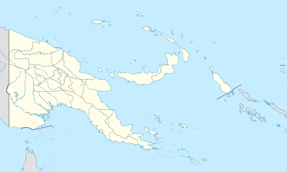 Chimbu Province Location within Papua New Guinea | |
| Coordinates: 6°26′S 145°0′E / 6.433°S 145.000°E | |
| Country | Papua New Guinea |
| Formation | 1966 |
| Capital | Kundiawa |
| Districts | |
| Government | |
| • Governor | Noah Kool- |
| Area | |
| • Total | 6,112 km2 (2,360 sq mi) |
| Population (2011 census) | |
| • Total | 376,473 |
| • Density | 62/km2 (160/sq mi) |
| Time zone | UTC+10 (AEST) |
| HDI (2018) | 0.557[1] medium · 9th of 22 |
Chimbu, more frequently spelled Simbu, is a province in the Highlands Region of Papua New Guinea. The province has an area of 6,112 km2 and a population of 376,473 (2011 census). The capital of the province is Kundiawa. Mount Wilhelm, the tallest mountain in Papua New Guinea is on the border of Eastern part of Simbu and the Western part of Madang Province.
Geography
Chimbu is located in the central highlands cordillera of Papua New Guinea. It shares geographic and political boundaries with five provinces: Jiwaka, Eastern Highlands, Southern Highlands, Gulf and Madang. It is a significant source of organically produced coffee.
Chimbu is a province with limited natural resources and very rugged mountainous terrain. The economic progress of the province has been slower than some other highlands provinces.
Education
There are seven secondary schools in the province: Kondiu Rosary, Yauwe Moses, Kerowagi, Muaina, Gumine, Mt Willem and Kundiawa Day Secondary School. The province also has many high and primary schools.
Districts and LLGs
The province is subdivided into six districts, with each district further subdivided into 18 rural LLGs and 2 urban LLGs areas. Each of the RLLGs are headed by a President and Urban LLG by a Mayor. Each LLGs have various council wards represented by a councillor who sits in the Council Assembly. All the councillors are democratically elected and Presidents are elected in the Council Assembly. For census purposes, the LLG areas are again subdivided into wards and those into census units.[2][3]
| District | District Capital | LLG Name |
|---|---|---|
| Chuave District | Chuave | Chuave Rural |
| Elimbari Rural | ||
| Siane Rural | ||
| Gumine District | Gumine | Bomai-Gumai Rural |
| Gumine Rural | ||
| Mount Digine Rural | ||
| Salt Nomane Karamui District | Kilau | Karimui Rural |
| Nomane Rural | ||
| Salt Rural | ||
| Kerowagi District | Kerowagi | Gena-Waugla Rural |
| Upper-Lower Koronigl Rural | ||
| Kerowagi Urban | ||
| Kup Rural | ||
| Kundiawa-Gembogl District | Kundiawa | Kundiawa Urban |
| Mitnande Rural (Mount Wilhelm Rural) | ||
| Niglkande Rural | ||
| Waiye Rural | ||
| Sina Sina-Yonggomugl District | Yonggomugl | Tabare Rural (Sinasina) |
| Suai Rural (Suwai) | ||
| Yonggomugl Rural |
Political governance and administration
Chimbu provincial leaders
The province was governed by a decentralised provincial administration, headed by a Premier, from 1977 to 1995. Following reforms taking effect that year, the national government reassumed some powers, and the role of Premier was replaced by a position of Governor, to be held by the winner of the province-wide seat in the National Parliament of Papua New Guinea.[4][5]
Premiers (1976–1995)
| Premier | Term |
|---|---|
| Siwi Kurondo | 1976–1978 |
| Mathew Siune | 1978–1984 |
| provincial government suspended | 1984–1986 |
| Peter Gul | 1986–1988 |
| David Mai | 1988–1992 |
| Edward Bare | 1992–1993 |
| Edward Aba | 1993–1995 |
Governors (1995–present)
| Governor | Term |
|---|---|
| Yauwe Riyong | 1995–1997 |
| Louis Ambane | 1997–1998 |
| Simeon Wai | 1998–1999 |
| Louis Ambane | 1999–2003 |
| Alphonse Willie | 2003–2004 |
| Peter Launa | 2004–2007 |
| John Garia | 2007–2012 |
| Noah Kool | 2012–2017 |
| Micheal Dua Bogai | 2017–2022 |
| Noah Kool | 2022–present |
Members of the National Parliament
The province and each district is represented by a Member of the National Parliament. There is one provincial electorate and each district is a local ("Open") electorate.[6]
| Electorate | Name |
|---|---|
| Chimbu Provincial | Noah Kool |
| Chuave Open | James Nomane |
| Gumine Open | Dawa Dekena |
| Salt Nomane Karamui Open | Francis Yori Alua |
| Kerowagi Open | Francis Kikin Siune |
| Kundiawa-Gembogl Open | Dilu Muguwa |
| Sinasina-Yonggomugl Open | Kerenga Kua |
See also
References
- ↑ "Sub-national HDI - Area Database - Global Data Lab". hdi.globaldatalab.org. Retrieved 2020-04-18.
- ↑ "Census Figures by Wards - Highlands Region". www.nso.gov.pg. 2011 National Population and Housing Census: Ward Population Profile. Port Moresby: National Statistical Office, Papua New Guinea. 2014. Archived from the original on 2019-05-18. Retrieved 2019-06-04.
- ↑ "Final Figures". www.nso.gov.pg. 2011 National Population and Housing Census: Ward Population Profile. Port Moresby: National Statistical Office, Papua New Guinea. 2014. Archived from the original on 2015-09-06. Retrieved 2019-06-04.
- ↑ May, R. J. "8. Decentralisation: Two Steps Forward, One Step Back". State and society in Papua New Guinea: the first twenty-five years. Australian National University. Retrieved 31 March 2017.
- ↑ "Provinces". rulers.org. Retrieved 31 March 2017.
- ↑ "NATIONAL PARLIAMENTARY ELECTIONS 2012". PNG Electoral Commission. Archived from the original on 15 August 2012. Retrieved 12 April 2017.
{{cite web}}: CS1 maint: bot: original URL status unknown (link)
- Deck, D. Sipu-u-u-u to Simbu, Paradise Magazine
| Chuave District | ||
|---|---|---|
| Gumine District | ||
| Karimui-Nomane District | ||
| Kerowagi District | ||
| Kundiawa-Gembogl District | ||
| Sina Sina-Yonggomugl District |
| |