Savanne
Savannah | |
|---|---|
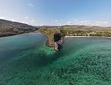
.jpg.webp) Rochester Falls | |
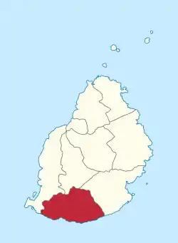 Map of Mauritius island with Savanne District highlighted | |
| Coordinates: 20°28′S 57°30′E / 20.467°S 57.500°E | |
| Country | |
| Government | |
| • Type | District Council |
| • Chairman | Mr. Jugurnauth Sridhur |
| • Vice Chairman | Mr. Chengan Joovalen |
| Area | |
| • Total | 244.8 km2 (94.5 sq mi) |
| Population (2015)[2] | |
| • Total | 68,585 |
| • Rank | 8th in Mauritius |
| • Density | 280/km2 (730/sq mi) |
| Time zone | UTC+4 (MUT) |
| ISO 3166 code | MU-SA (Savanne) |
Savanne (Mauritian Creole pronunciation: [savan]) or Savannah is a district of Mauritius, situated in the south of the island. The district has an area of 244.8 km2 and the population estimate was at 68,585 as at 31 December 2015.[2] The southern part of the island is one of the most scenic and unspoilt.
History
Places of interest
- The World of Seashells
- Bel Ombre Nature Reserve (also known as Heritage Nature Reserve)
- Macondé View Point
Places
The Savanne District include different regions; however, some regions are further divided into different suburbs.[2][3]
- Baie-du-Cap
- Bel-Ombre
- Bénarès
- Batimarias
- Bois-Chéri
- Britannia
- Camp Diable
- Chamouny
- Chemin-Grenier
- Grand Bois
- La Flora
- Rivière-des-Anguilles
- Rivière Du Poste
- Saint-Aubin
- Souillac
- Surinam
Maconde Point in Baie-du-Cap
See also
Wikimedia Commons has media related to Savanne District.
References
- ↑ "Archived copy". Archived from the original on 4 April 2014. Retrieved 8 March 2014.
{{cite web}}: CS1 maint: archived copy as title (link) - 1 2 3 Ministry of Finance & Economic Development (2016). "ANNUAL DIGEST OF STATISTICS 2015" (PDF). August. Government of Mauritius: 19. Retrieved 23 December 2016.
{{cite journal}}: Cite journal requires|journal=(help) - ↑ Statistic office of Mauritius (2011). "Housing and population Census 2011" (PDF). Government of Mauritius. Archived from the original (PDF) on 21 October 2013. Retrieved 12 September 2012.
{{cite journal}}: Cite journal requires|journal=(help)
| Subdivisions |
| .svg.png.webp) | ||||||||||||
|---|---|---|---|---|---|---|---|---|---|---|---|---|---|---|
| Politics | ||||||||||||||
| Economy | ||||||||||||||
| Society |
| |||||||||||||
This article is issued from Wikipedia. The text is licensed under Creative Commons - Attribution - Sharealike. Additional terms may apply for the media files.