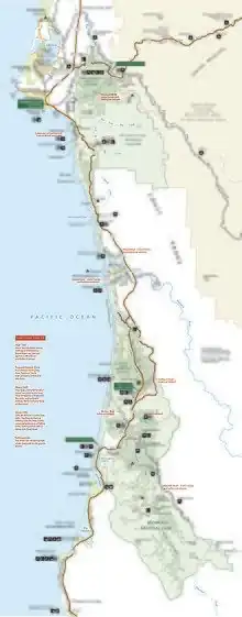
| Redwood National and State Parks | |
|---|---|
IUCN category V (protected landscape/seascape) | |
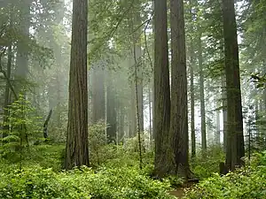 A forest of coast redwoods in fog | |
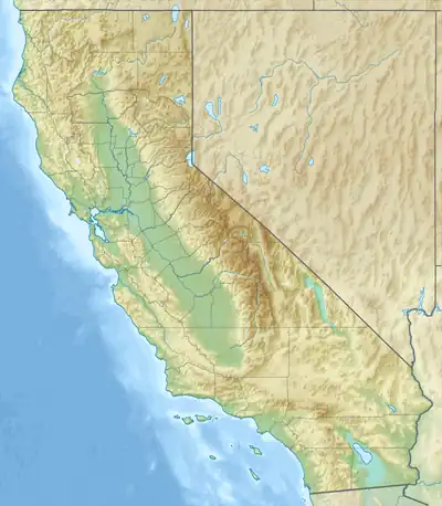  | |
| Location | Humboldt County & Del Norte County, California, US |
| Nearest city | Crescent City |
| Coordinates | 41°18′N 124°00′W / 41.3°N 124°W |
| Area | 138,999 acres (562.51 km2)[1] |
| Established | October 2, 1968 |
| Visitors | 458,400 (in 2022)[2] |
| Governing body | National Park Service and California Department of Parks and Recreation |
| Website | https://www.nps.gov/redw/ |
| Criteria | Natural: (vii), (ix) |
| Reference | 134 |
| Inscription | 1980 (4th Session) |
The Redwood National and State Parks (RNSP) are a complex of one national park and three California state parks located in the United States along the coast of northern California. The combined RNSP contain 139,000 acres (560 km2), and include Redwood National Park, Del Norte Coast Redwoods State Park, Jedediah Smith Redwoods State Park, and Prairie Creek Redwoods State Park. Located within Del Norte and Humboldt counties, the four parks protect 45 percent of all remaining coast redwood (Sequoia sempervirens) old-growth forests. The species is the tallest, among the oldest, and one of the most massive tree species on Earth. The coast redwood was named an endangered species in 2011. The parks preserve other indigenous flora, fauna, grassland prairie, cultural resources, waterways, and 37 miles (60 km) of pristine coastline.
In 1850, old-growth redwood forest covered more than two million acres (8,100 km2) of the California coast. The northern portion of that area was originally inhabited by Native Americans who were forced out of their land by gold seekers and timber harvesters. The enormous redwoods attracted timber harvesters to support the gold rush in more southern regions of California and the increased population from booming development in San Francisco and other places on the West Coast. After many decades of unrestricted clear-cut logging, serious efforts toward conservation began. By 1918, the work of the Save the Redwoods League, founded to preserve remaining old-growth redwoods, resulted in the establishment of Prairie Creek, Del Norte Coast, and Jedediah Smith Redwoods State Parks among others. The federally managed Redwood National Park was created in 1968, by which time nearly 90 percent of the original redwoods had been logged. In 1994, the National Park Service (NPS) and the California Department of Parks and Recreation combined Redwood National Park with the three abutting Redwoods State Parks as a single administrative unit for the purpose of cooperative forest management and stabilization of forests and watersheds.
The ecosystems of the RNSP preserve a number of threatened animal species, such as the tidewater goby, Chinook salmon, northern spotted owl, and Steller's sea lion, though the tidewater goby and the candlefish are believed to have been extirpated from the park in 1968.[3] In recognition of the rare ecosystem and cultural history found in the parks, the United Nations designated them a World Heritage Site in 1980.
History
Native Americans

Modern day Native American nations such as the Yurok, Tolowa, Karuk, Chilula, and Wiyot have historical ties to the region.[4] Describing "a diversity in an area that size that has probably has never been equaled anywhere else in the world", historian David Stannard accounts for more than thirty native nations living for millennia in northwestern California.[5] Scholar Gail L. Jenner estimates that "at least fifteen" tribal groups inhabited the coastline.[6]
The Yurok, Chilula, and Tolowa were the most connected to the places we now call parks.[7] Based on an 1852 census, anthropologist Alfred Kroeber estimated that the Yurok population in that year was around 2,500.[8] Historian Ed Bearss described the Yurok as the most populous in the area, estimating that there were around 55 villages.[8] Until the 1860s, the Chilula lived in the middle region of the Redwood Creek valley in close company with the redwood trees.[9] They primarily settled along Redwood Creek between the coast and Minor Creek, California, and in summer they would range into and camp in the Bald Hills.[10] The Tolowa were located near the Smith River, and on lands that are now part of Jedediah Smith State Park, an area which has been inhabited for about 8,500 years.[11]
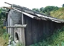
The tribes harvested coast redwoods and processed them into planks, using them as building material for boats, houses, and small villages.[12] To construct buildings, the planks would be erected side by side in a narrow trench, with the upper portions lashed with willow or hazel and held by notches cut into the supporting roof beams. Redwood boards were used to form a two- or three-pitch roof.[13]
Redwoods were not just a useful resource for indigenous groups. Jenner notes that "their lives were – and are – built on more than just wood, although the redwood was the source of much of their material culture; their lives were enmeshed in the very character and fabric of the trees." Minnie Reeves, a Chilula tribal elder and religious leader, said in 1976 that the Chilula are "people from within the redwood tree".[14] Reeves elaborates that the trees are a gift from the creator as a demonstration of love: "Destroy these trees and you destroy the Creator's love. And if you destroy that which the Creator loves so much, you will eventually destroy mankind."[15] To the Yurok, the trees are sacred living beings that "stand as 'guardians' over sacred places". Indigenous people regard traditional houses made of redwood trees as "living beings" too, since, according to Bearss, "the redwood that formed its planks was itself the body of one of the Spirit Beings", which were considered, in his words, to be a "divine race who existed before humans in the redwood region and who taught people the proper way to live there".[14]
Arrival of European Americans
Prior to Jedediah Smith in 1828, no other explorer of European descent is known to have explored the interior of the Northern California coastal region. Smith and nineteen companions left San Jose, California, and explored what are now called the Trinity, Smith, and Klamath rivers, passing through coast redwood forests and trading with Native American groups. They reached the coast near Requa, parts of which are within the parks' boundaries.[16]
The California Gold Rush of 1848 brought hundreds of thousands of Europeans and Americans to California,[17] and the discovery of gold along the Trinity River in 1850 brought many of them to the region of the parks. This quickly led to conflicts wherein native peoples were displaced, raped, enslaved, and massacred.[18] By 1895, only one third of the Yurok in one group of villages remained; by 1919, virtually all members of the Chilula tribe had either died or been assimilated into other tribes.[19] The Tolowa—whose numbers Bearss estimates at "well under 1,000" by the 1850s—had a population of about 120 in 1910,[20] having been nearly extinguished in massacres by settlers between 1853 and 1855.[21]
The miners logged redwoods for building; when this minor gold rush ended, some of them turned again to logging, cutting down the giant redwood trees.[22]
State park preservation

After extensive logging, conservationists and concerned citizens began to seek ways to preserve remaining trees, which they saw being logged at an alarming rate.[22] Stumbling blocks slowed conservation: objections and some innovations came from the logging industry,[lower-alpha 1] construction of the Redwood Highway brought roadside attractions and more visitors to the trees,[25] Congress failed to act,[lower-alpha 2] and voracious demand for lumber came with the post-World War II construction boom.[lower-alpha 3]
Organizations formed to preserve the surviving trees:[27] concerned about the sequoia of Yosemite, John Muir cofounded the Sierra Club in 1892.[28] The Sempervirens Club was cofounded in 1900 by artist Andrew P. Hill who lobbied the media, and saw the oldest state park created along with the state park system.[29] In 1916, politician William Kent purchased land outright and helped to write the bill founding the National Park Service (NPS). In 1918, John Merriam and other members of the Boone and Crockett Club[30] founded the Save the Redwoods League.[31] The league bought land and donated funds for land purchases. Historian Susan Schrepfer writes that in a sixty-year-long marathon, the Save the Redwoods League and the Sierra Club were racing the logging companies for the old trees.[32]
At first, in 1919, with Congress showing interest but no appropriations, NPS director Stephen Mather formed the NPS system with private wealth[33]—he and his wealthy friends purchased parkland with their own money.[34] Balancing opponents and supporters, the Save the Redwoods League saw their compromise bill pass in 1923, allowing condemnation for park acquisition with state oversight.[35] In 1925, the league backed a bill that would authorize a statewide survey by a landscape architect and permit land acquisition and condemnation for parks. In 1926, the league retained Frederick Law Olmsted to make that survey.[36] The league added to their bill a proposed state constitutional amendment authorizing up to $6 million ($99.2 million in 2022) in bonds to equally match private donations for state land purchases.[37] After sustaining a governor's veto in 1925,[36] the league broadened their efforts to include the whole state, mounted a publicity campaign, and gained the support of the Los Angeles Times.[38] A new governor signed the parks bill into law in 1927, and the bond issue was approved in the 1928 election.[38]
In 1927, Olmsted's survey was complete, and concluded that only three percent of the state's redwoods could be preserved. He recommended four redwood areas for parks which became Prairie Creek Redwoods, Del Norte Coast Redwoods, and Jedediah Smith Redwoods State Parks. A fourth became Humboldt Redwoods State Park, by far the largest of the individual Redwoods State Parks, but not in the Redwood National and State Parks system.[39] Now armed with matching funds after 1928, the league bought more land and added to these parks as conditions allowed.[40]
National park
The NPS proposed a redwoods national park in 1938. The Save the Redwoods League opposed it, highlighting a division between preservationists who preferred unembellished nature and a segment of the park service who wished to provide recreation and playgrounds for the public.[41] Both the league and the Sierra Club wanted a redwoods national park by the 1960s, but the club and the league supported different locations.[42] The club and the league were antagonists during the 1960s,[43] often on opposite sides of national park arguments, until 1971 when the league backed a club position,[44] and the late 1970s when the league became a club member.[45]
The Sierra Club wanted the largest possible park and usually sought help from the federal government.[46] More cautious, the Save the Redwoods League tended to accommodate industry and support the state of California.[47] When the agency had no funds in 1963, the National Geographic Society funded an NPS survey of the redwoods.[48] In 1964, NPS released its ideas for three different sized redwood national parks.[49] In 1964, Congress passed the Land and Water Conservation Fund to allow federal funds to purchase parkland.[50]
Writing for the Arcata lumber company, Willard Pratt said, "The Sierra Club demonstrated a basic political fact of life: Opposition to particular preservation proposals usually is local while support is national. If decision making can be placed at the national level, preservation usually can win".[51]
Initially opposing the park in the 1960s, the Arcata, Georgia-Pacific, and Miller lumber businesses operated right up to the boundaries being discussed.[52] In 1965, five logging companies formally objected to any redwood national park.[51] Schrepfer wrote that the final bill divided the impact between the lumber companies, between California counties, and tried to appeal to both the league and the club. Schrepfer says that in large part, the bill was framed on the loggers' terms.[53] After intense lobbying of Congress, the bill creating Redwood National Park was signed by President Lyndon B. Johnson in October 1968.[54]
The Save the Redwoods League donated parcels in 1974 and 1976.[55] The club found the Olmsted plan of delicately choosing sites was the wrong approach to defend against tractor clearcutting.[56] In 1977, the club said that only ridge-to-ridge land acquisition around a water channel could preserve a watershed and thus the trees.[57] Amidst both local support of environmentalists and opposition from local loggers and logging companies, 48,000 acres (190 km2) were added to Redwood National Park in an expansion signed by President Jimmy Carter in 1978.[58] The purchase included lands that had already been logged, and the NPS was charged with restoring the land and reducing soil erosion.[59] At hundreds of millions of dollars, it was the most expensive land purchase ever approved by Congress.[58] By 1979, the league had preserved 150,000 acres (610 km2) or nearly twice the area that the federal government was able to save with park legislation.[56]
The United Nations designated the Redwood National and State Parks a World Heritage Site in 1980. The evaluation committee noted cooperative management, and ongoing research in the parks by Humboldt State University and other partners.[60]
The parks are within the California Coast Ranges and their resources are considered irreplaceable.[61] In 2017, the US withdrew them along with more than a dozen other reserves from the World Network of Biosphere Reserves. [62]
Park management
Redwood National Park is directly managed by the NPS from its office in Crescent City, California.[63] The three state parks are overseen by the California Department of Parks and Recreation.[64] The park management coordinates with tribal leaders, as the parks contain land and village sites belonging to groups including the Yurok and Tolowa.[18][10] NPS manages about 1,400 acres (5.7 km2) of federal park land and waters that lie within the Yurok Indian Reservation.[65]
Redwood National Park management oversees many other details aside from the redwoods and organic species that reside within the park boundaries. They regulate areas that are off limits to motor vehicles, boats, drones, horses, pets and even bicycles. In addition, park management establishes limitations on camping, campfires, food storage and backcountry use, as well as necessary permits needed.[66]
When it opened in 1969, Redwood National Park had only six permanent employees.[67] Early park managers prioritized restoring existing structures, rehabilitating the watershed, and developing wildlife management plans.[68] Until 1980, managers assumed that the three state parks, which are contained within the boundaries of the national park, would be donated to the NPS.[65] The donation did not happen,[65] and NPS and the state signed a memorandum in 1994 governing joint management and agreeing to the name "Redwood National and State Parks".[69]
Natural resources
The Redwood National and State Parks form an important protected region, containing the largest contiguous old-growth coast redwood forest as well as habitats for endangered species.[70][71]
Coast redwood
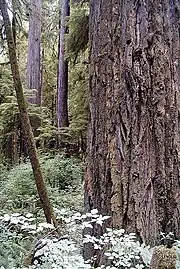
Coast redwoods (Sequoia sempervirens) are the tallest trees on Earth. The tallest specimen alive is 380 feet (120 m)[72] and the species has a theoretical maximum height of between 400 and 427 feet (122 and 130 m).[73] Not as long-lived as its relative Sequoia gigantea,[74] mature coast redwoods live an average of 500–700 years and a few are documented to be 2,000 years old.[75] Coast redwood is a shade tolerant conifer.[76] It has no taproot, and its roots spread into a wide lateral root system.[77] Due to a thick protective bark and high tannin content, it is highly resistant to disease.[75] As of 1990, a stand in Humboldt Redwoods State Park had the greatest biomass ever recorded.[77] Redwood trees develop enormous limbs that accumulate deep organic soils from which new tree-sized redwood trunks can grow.[78] Plants called epiphytes which normally grow on the forest floor grow in these soils.[79] Mats of epiphytic ferns well above ground are home to invertebrates, mollusks, earthworms, and salamanders.[80] During drought seasons, some treetops die back, but the trees do not die outright. Instead, redwoods developed lignotubers to regrow new trunks from other limbs.[81] These secondary trunks called reiterations develop root systems in the accumulated soils at their bases.[81] This helps transport water to the highest reaches of the trees.[81] Redwoods prefer sheltered slopes, and thrive on moist flat ground along rivers below 1,000 feet (300 m) in elevation.[76] Coastal fog provides about 40 percent of their annual water intake.[82]
Redwoods have existed along the coast of northern California for at least 20 million years and are related to tree species that existed 160 million years ago in the Jurassic era.[82] One of three living redwood species, the coast redwood is closely related to the giant sequoia of central California and more distantly to the dawn redwood, which is indigenous to the Sichuan–Hubei region of China.[83] The current range of coast redwood is a 450-mile (720 km) long and 5-to-35-mile (8 to 56 km) wide strip along the west coast of the United States from the northern California coast north to the southern Oregon Coast.[84] It is estimated that old-growth redwood forest once covered close to two million acres (8,100 km2) of coastal northern California.[85] Almost half (45 percent) of the redwoods remaining in California are found in RNSP, and 96 percent of all old-growth redwoods have been logged. The parks protect 38,982 acres (157.75 km2) of old-growth forest, almost equally divided between federal and state management.[75] The International Union for Conservation of Nature named the coast redwood an endangered species in 2011.[86]
Discovered in the parks in 2006, the tallest living tree in the world is Hyperion[87] at 380 feet (120 m), followed by Helios at 377 feet (115 m), and Icarus at 371 feet (113 m).[72] For many years thought to be the tallest, one specimen named simply "Tall Tree" within the RNSP in Prairie Creek Redwoods State Park was measured at 367.8 feet (112.1 m). "So many people have stood on the base of the tree that the ground is hard packed," said Professor Stephen C. Sillett of Humboldt State in the 1990s.[88] The top 10 feet (3.0 m) of the tree died in the 1970s, and fell off in the 1990s.[88] In 2022 after documenting damage caused by visitors to the tallest living tree, NPS announced a penalty for those who approach it of up to a $5,000 fine ($5,000 in 2022) and six months in jail,[72] and it shows visitors instead to views of other trees.[89]
Other flora
Coast redwood tends to dominate in places it likes but often can be found together with also-fast-growing coast Douglas-fir trees. Closer to the ocean, red alder grow in place of the salt-water intolerant redwood.[90] The tallest known Sitka spruce grows in the parks.[91] Sitka spruce are plentiful along the coast, better adapted to salty air than other species. Other associated trees are the tanoak, Pacific madrone, bigleaf maple, and California laurel.[92]
Huckleberry and snowberry are part of the forest understory.[92] The California rhododendron and azalea are flowering shrubs common in the parks.[92] Plants such as the sword fern and redwood sorrel are prolific.[92]
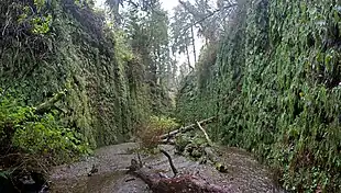
In Prairie Creek Redwoods State Park, Fern Canyon is a well-known ravine 50 feet (15 m) deep,[90] with walls completely covered in ferns—California maidenhair, deer fern, California polypody, licorice fern, and western swordfern.[93] The ancestors of some of these ferns reach back 325 million years.[94]
Fauna

The ecosystems of the RNSP preserve a number of rare animal species. Numerous ecosystems exist, with seacoast, river, prairie, and densely forested zones all within the park. Over 40 species of mammals have been documented, including the black bear, coyote, cougar, bobcat, beaver, river otter, and black-tailed deer. Roosevelt elk are the most readily observed of the large mammals in the park.[95] Successful herds, brought back from the verge of extinction in the region, are now common in park areas.[95] Many smaller mammals live in the high forest canopy. Different species of bats, such as the big brown bat, and other smaller mammals including the red squirrel and northern flying squirrel spend most of their lives well above the forest floor.[96]
About half of RNSP's 28 species that are federally recognized as endangered, threatened, or candidates can be seen in the parks.[3] The bald eagle, which usually nests near a water source, is listed as a state of California endangered species.[97] The Chinook salmon, northern spotted owl, and Steller's sea lion are a few of the other animal species that are threatened.[3][98] The tidewater goby is a federally listed endangered species that lives near the Pacific coastline that were extirpated from the parks in 1968 when shoreline alterations affected the water's salinity. The candlefish soon followed in the 1970s.[99] Sea otters were extirpated in the parks at the turn of the 20th century but river otters remain.[100] Also endangered, the marbled murrelet can nest high on redwood branches.[95]
Along the coastline, California sea lions, Steller sea lions and harbor seals live near the shore and on seastacks, rocky outcroppings forming small islands just off the coast.[100] Dolphins and Pacific gray whales are occasionally seen offshore.[100] Brown pelicans and three species of cormorants are mainly found on cliffs along the coast and on seastacks, while sandpipers and three species of gulls inhabit the seacoast and inland areas.[101] Inland, freshwater-dependent birds such as the common merganser, osprey, red-tailed hawk, herons, and jays are a few of the bird species that have been documented.[101] Approximately 280 bird species, or about one third of those found in the US, have been documented within park boundaries.[101]
Reptiles like four species of sea turtle can be found offshore and sometimes on beaches.[102] Amphibians can be found in the parks, which the gopher snake,[103] tailed frog,[104] clouded salamander,[105] and three species of newt[106] call home. Well-known detritivores, the banana slug and the yellow-spotted millipede, inhabit the parks.[107]
NPS provides safety tips for visitors who encounter wildlife such as elk, black bears, and mountain lions, as well as poison oak and ticks.[108]
Invasive species
Currently, over 200 exotic species live in the RNSP. Of these, 30 have been identified as invasive species, and 10 of the 30 are considered threats to local species and ecosystems.[109] Exotic species currently account for about a quarter of the total flora in the parks.[109] Only about one percent of plant growth in old-growth areas are of exotic species, while areas such as the Bald Hills prairies have a relative exotic cover of 50 to 75 percent.[109] Spotted knapweed and poison hemlock were both under consideration in 2015 for addition to a high priority watch list maintained by the park system.[110]
Geography

The parks are located in the most seismically active area in the country.[111] Frequent minor earthquakes in the park and offshore under the Pacific Ocean have resulted in shifting river channels, landslides, and erosion of seaside cliffs.[111] The North American, Pacific, and Gorda Plates are tectonic plates that all meet at the Mendocino Triple Junction, only 100 miles (160 km) southwest of the parks.[111] During the 1990s, more than nine magnitude 6.0 earthquakes occurred along this fault zone resulting in one death and major financial loss, and there is always potential for a major earthquake.[112] The area is the most tsunami-prone in the continental U.S., and visitors to the seacoast are told to seek higher ground immediately after any significant earthquake.[108] The park's altitude is below sea level up to 837 meters (2,746 ft) at Rodgers Peak.[60]
Both coastline and the mountains of the California Coast Ranges can be found within park boundaries.[60] The majority of the rocks in the parks are part of the Franciscan Assemblage,[60] uplifted from the ocean floor millions of years ago. These sedimentary rocks are primarily sandstone, siltstone, shale, and chert, with lesser amounts of metamorphic rocks such as greenstone.[60] Redwood Creek follows the Grogan Fault; along the west bank of the creek, schist and other metamorphic rocks can be found, while sedimentary rocks of the Franciscan Assemblage are located on the east bank.[60]
Climate
| Climate data for Redwood National and State Parks (Jedediah Smith Redwoods State Park; Del Norte County) | |||||||||||||
|---|---|---|---|---|---|---|---|---|---|---|---|---|---|
| Month | Jan | Feb | Mar | Apr | May | Jun | Jul | Aug | Sep | Oct | Nov | Dec | Year |
| Record high °F (°C) | 75 (24) |
80 (27) |
81 (27) |
86 (30) |
91 (33) |
98 (37) |
89 (32) |
93 (34) |
95 (35) |
90 (32) |
78 (26) |
72 (22) |
98 (37) |
| Mean daily maximum °F (°C) | 53.4 (11.9) |
55.0 (12.8) |
56.0 (13.3) |
56.9 (13.8) |
60.7 (15.9) |
63.4 (17.4) |
65.0 (18.3) |
65.1 (18.4) |
65.2 (18.4) |
62.6 (17.0) |
56.6 (13.7) |
52.7 (11.5) |
59.4 (15.2) |
| Mean daily minimum °F (°C) | 35.8 (2.1) |
36.5 (2.5) |
38.1 (3.4) |
39.9 (4.4) |
44.0 (6.7) |
47.6 (8.7) |
50.4 (10.2) |
50.8 (10.4) |
47.4 (8.6) |
42.9 (6.1) |
38.8 (3.8) |
35.5 (1.9) |
42.3 (5.7) |
| Record low °F (°C) | 18 (−8) |
19 (−7) |
24 (−4) |
27 (−3) |
24 (−4) |
33 (1) |
34 (1) |
36 (2) |
24 (−4) |
28 (−2) |
22 (−6) |
16 (−9) |
16 (−9) |
| Average precipitation inches (mm) | 12.18 (309) |
10.65 (271) |
10.31 (262) |
6.27 (159) |
3.94 (100) |
2.00 (51) |
0.37 (9.4) |
0.53 (13) |
1.21 (31) |
5.00 (127) |
11.42 (290) |
15.72 (399) |
79.60 (2,022) |
| Average snowfall inches (cm) | 0.4 (1.0) |
0.4 (1.0) |
0.1 (0.25) |
0.0 (0.0) |
0.0 (0.0) |
0.0 (0.0) |
0.0 (0.0) |
0.0 (0.0) |
0.0 (0.0) |
0.0 (0.0) |
0.0 (0.0) |
0.1 (0.25) |
1.1 (2.8) |
| Average precipitation days (≥ 0.01 in) | 17.6 | 15.7 | 17.1 | 14.0 | 9.0 | 5.3 | 1.9 | 2.0 | 3.8 | 7.7 | 16.3 | 17.4 | 127.8 |
| Source 1: NOAA (normals, 1981–2010)[113] | |||||||||||||
| Source 2: Western Regional Climate Center (records and snowfall 1948–2006)[114] | |||||||||||||

The Redwood National and State Parks have a temperate rainforest climate with cool-summer Mediterranean characteristics.[115] The nearby Pacific Ocean has major effects on the climate in the parks.[116] Temperatures near the coast mostly remain between 40 and 60 degrees Fahrenheit (4–15 °C) all year.[116] Redwoods tend to grow in this area of steadily temperate climate, though most grow at least a mile or two (1.5–3 km) from the coast to avoid the saltier air, and they never grow more than 50 miles (80 km) from it. In this humid coastal zone, the trees receive moisture from both heavy winter rains and persistent summer fog.[117] The presence and consistency of the summer fog is actually more important to overall health of the trees than the precipitation. This fact is born out in annual precipitation totals, which range between 25 and 122 inches (64 and 310 cm) annually, with healthy redwood forests throughout the areas of less precipitation because excessive needs for water are mitigated by the ever-present summer fog and the cooler temperatures it ensures. Snow is uncommon even on peaks above 1,500 feet (460 m),[118] but light snow mixed with rain is common during the winter months.
Parts of the parks are threatened by climate change. Increasing average temperatures have led to reduced water quality, affecting the fish and other fauna, and rising sea levels threaten to damage park structures near the coast.[119] The redwoods benefit from higher carbon levels and are resilient against temperature changes.[119] Scientists fear climate change is likely to shift the range in which coast redwoods live to outside protected areas,[120] and many have done research on assisted migration.[121][lower-alpha 4]
Fire
The California Department of Forestry and Fire Protection (CAL FIRE) is responsible for fire management in the redwoods state parks, and NPS manages fire in the national park.[125]

Because coast redwood bark—in places up to a foot thick—has no resin, the trees are resistant to fire and will regrow after burning.[126] The redwood forest is foggy and humid and not generally susceptible to fire, and lightning strikes among redwoods are rare, meaning that most fires are anthropogenic.[127] A 2003 fire was an exception; a lightning storm started fires in least 274 California locations, including the Canoe Fire in Humboldt Redwoods State Park, which burned from September through October.[127] By about 11 percent, old-growth coast redwoods have the greatest volume of fuels of any forest type.[128]
After they arrived c. 1300[129] and until white settlers invaded their lands in the 1850s,[130] the Tolowa people intentionally set low-intensity ground fires.[lower-alpha 5] Indigenous residents used fire to protect a primary food source, tanoak acorns.[132] Their fires improved their hunting grounds, reduced pests, and decreased the likelihood of larger fires.[130] There is evidence that medium-intensity surface fire was set regularly in the area,[133] but today, after decades of fire supression and resulting increased fuel density, maximum-intensity crown fire has taken the place of surface fires when fire occurs.[134] Near the tree's crown, coast redwood bark may be less than one inch thick.[135]
Since its founding in 1905, and especially with its policies of the 1930s, the United States Forest Service (USFS) has for the most part defended both human settlements and timber companies against fire using wildfire suppression techniques intended to eliminate fire.[136] Repealed in 1937, the 1850 California Act for the Government and Protection of Indians[137]—for which the state apologized in 2019[138]—provided that "Any person was subject to fine or punishment if they set the prairie on fire, or refused to use proper exertions to extinguish the fire."[139] Recognizing that fire has benefits, the service began in the 1970s to change policy to allow fire to burn.[136] More recently in the 2000s, USFS came full circle to embrace indigenous fire management when USFS researcher Steve Norman advocated "a modified Native American burning model".[140]
Looking back at their 8,000 years of experience,[141] and ahead seven generations or 100 to 120 years, Native Americans understand and use prescribed burns, broadcast burns, and cultural burning.[142] In 2020, the Karuk tribe formed the Endowment for Eco-Cultural Revitalization[143] to promote cultural burning[144] in their homeland in the park region.[145] Controlled fires in the grassland areas of the parks are used to control invasive species,[146] hold back the spread of Douglas fir,[140] and increase the availability of materials needed by local tribes for basket weaving.[146]
Recreation
The park has five visitor centers, where general information, maps, and souvenirs are available; some of the centers offer activities during the summer, led by the park rangers.[147] There is no entry fee for the RNSP, though some camping areas and park areas require paid passes.[148]
Since the late-2019 closure of the DeMartin Redwood Youth Hostel, a low-amenities shared lodging facility (near Klamath),[149] there are no hotels or motels within the parks' boundaries. However, nearby towns such as Klamath, Requa, and Orick provide small hotels and inns, with extensive lodging options available in the regional trading centers: Crescent City on the northern end of the park and Arcata and Eureka located to the south. The park is about 260 miles (420 km) north of San Francisco and 300 miles (480 km) south of Portland, Oregon; U.S. Route 101 passes through it from north to south. The Smith River National Recreation Area, part of the Six Rivers National Forest, is adjacent to the north end of the RNSP.
The state parks have four frontcountry campgrounds which can be accessed by vehicle and used for a fee; the parks' website suggests making a reservation. These are at Mill Creek campground in Del Norte Coast Redwoods State Park and Jedediah Smith campground in Jedediah Smith Redwoods State Park, which together have 251 campsites; the Elk Prairie campground in Prairie Creek Redwoods State Park, which has 75; and the Gold Bluffs Beach campground which has 26. Other nearby parks and recreation areas have additional camping options.[150]
Hiking is the only way to reach the seven backcountry camping areas, the use of which requires a permit. Camping is only allowed in designated sites, except on gravel bars along Redwood Creek that allow for dispersed camping. Proper food storage to minimize encounters with bears is strongly enforced, and hikers and backpackers are required to take out any trash they generate.[151]
Almost 200 miles (320 km) of hiking trails exist in the parks. Throughout the year, trails are often wet and hikers need to be well prepared for rainy weather and consult information centers for updates on trail conditions. Some temporary footbridges are removed during the rainy season, as they would be destroyed by high streams.[151]
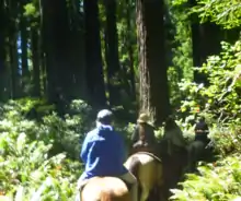
Horseback riding and mountain biking are allowed on certain trails.[152] Kayaking is permitted, with ranger-led kayak tours offered during the summer.[153] Kayakers and canoeists frequently travel the Smith River,[154] which is the longest undammed river remaining in California.[153] Visitors can fish for salmon and trout in the Smith and Klamath rivers, and the beach areas offer opportunities to catch smelt and perch. A California sport fishing license is required to fish any of the rivers and streams.[155]
See also
Notes
- ↑ Two highlights in the long battle:
• Pacific Lumber (PL) introduced "selective cutting" and "sustained yield", policies that fell to a hostile takeover in 1985. PL declared bankruptcy in 2007. Today PL is Mendocino Redwood Company which restored management favorable to preservation.[23]
• Logging workers united in 1977. A 25-truck convoy featuring logging equipment crossed the country to deliver President Jimmy Carter a 9-ton peanut carved from old-growth redwood. The president refused the gift, and the Orick Peanut was returned to Orick, a logging town adjacent to the newly expanded park that saw substantial economic decline in the following decades.[24] - ↑ In 1911, U.S. Representative John E. Raker of California introduced legislation for the creation of a redwood national park but Congress took no action.[26]
- ↑ "It was the post World War II housing and economic boom caused the majority of old-growth redwoods to be clear cut. In just a few decades, hundreds of thousands of acres of old-growth redwoods on private lands were logged. By the 1960s, industrial logging had removed almost ninety percent of all the original redwoods."[22]
- ↑ Studies on assisted migration were conducted by groups including the USFS,[122] the Save the Redwoods League,[123] and the Canadian government.[124]
- ↑ Norman et al. set out in 2009 to correct the record by improving measurements (in 2009 fire events were counted at 10 to 30 centimetres (3.9 to 11.8 in) of tree height. Earlier studies were conflicting and found fires ranging from rare to frequent; studies finding rare fires were typically measured at 150 to 250 centimetres (59 to 98 in)). Remeasuring a new sample found 1 to 5 year frequency only around park open grasslands known as prairies, and not in Del Norte Coast Redwoods State Park. Direct comparisons cannot be made, but researchers found frequency of at least 6 to 10 years (more than 5 years) for other areas near the parks.[131]
References
- ↑ "NPS listing of acreage". National Park Service. September 30, 2022. Retrieved December 21, 2022.
- ↑ "Annual Visitation Report by Years: 2012 to 2022". National Park Service. Retrieved September 28, 2023.
- 1 2 3 "Threatened and Endangered Species". National Park Service. March 3, 2015. Retrieved December 21, 2022.
- ↑ Bearss 1982, Section 1A. The Yurok.
- ↑ Stannard 1993, pp. 21–22.
- ↑ Jenner 2016, p. 20.
- ↑ Jenner 2016, pp. 20–21.
- 1 2 Bearss 1982, Section 1A. The Yurok.
- ↑ "The Chilula: Bald Hills People" (PDF). Park Newspaper (Visitor's Guide). National Park Service. 2002. p. 2. Retrieved August 11, 2023 – via National Park Service History eLibrary.
- 1 2 Bearss 1982, Section 1C. The Chilula.
- ↑ Jenner 2016, p. 23.
- ↑ Castillo, Edward D. (1998). "Short Overview of California Indian History". California Native American Heritage Commission. Archived from the original on October 26, 2008. Retrieved June 23, 2023.
- ↑ Nabokov & Easton 1990, p. 290.
- 1 2 Jenner 2016, pp. VII–VIII.
- ↑ Jenner 2016, p. 35.
- ↑ Jenner 2016, pp. 41–42.
- ↑ Jenner 2016, p. 44.
- 1 2 "American Indians". Area History. National Park Service. February 5, 2008. Retrieved July 2, 2023.
- ↑ "The Chilula". The Indians of the Redwoods. National Park Service. Retrieved August 14, 2023.
- ↑ Bearss 1982, Section 1B. The Tolowa.
- ↑ Jenner 2016, p. 54.
- 1 2 3 "Logging". Area History. National Park Service. Retrieved August 14, 2023.
- ↑ Jenner 2016, pp. 112–114.
- ↑ Rosalsky, Greg (June 21, 2022). "The tale of a distressed American town on the doorstep of a natural paradise". National Public Radio.
- ↑ Jenner 2016, Chapter 12: The Redwood Highway Cuts a Path Through the Trees.
- ↑ Jenner 2016, p. 96.
- ↑ Jenner 2016, p. 99.
- ↑ Jenner 2016, p. 91.
- ↑ Jenner 2016, pp. 92–95.
- ↑ Jenner 2016, p. 127.
- ↑ Schrepfer 1983, pp. 4, 12.
- ↑ Schrepfer 1983, p. xiv.
- ↑ Schrepfer 1983, p. 231.
- ↑ Schrepfer 1983, pp. 18, 20.
- ↑ Schrepfer 1983, p. 29.
- 1 2 Schrepfer 1983, p. 31.
- ↑ Schrepfer 1983, p. 32.
- 1 2 Schrepfer 1983, p. 33.
- ↑ Schrepfer 1983, pp. 33–36.
- ↑ Schrepfer 1983, p. 36.
- ↑ Schrepfer 1983, p. 52, 60–61.
- ↑ Schrepfer 1983, pp. 117–118.
- ↑ Schrepfer 1983, p. 237.
- ↑ Schrepfer 1983, p. 214.
- ↑ Schrepfer 1983, pp. 79, 110–111, 124, 127, 204.
- ↑ Schrepfer 1983, pp. 111, 122.
- ↑ Schrepfer 1983, pp. 111, 230, 239.
- ↑ Schrepfer 1983, p. 117.
- ↑ Schrepfer 1983, pp. 118, 121.
- ↑ Schrepfer 1983, pp. 120–121.
- 1 2 Pratt (Arcata), Willard E. "Chronology: Establishment of the Redwood National Park" (PDF). NPS History. Retrieved December 6, 2023.
- ↑ Schrepfer 1983, pp. 140–141, 150–151, 154.
- ↑ Schrepfer 1983, pp. 156, 162.
- ↑ Schrepfer 1983, p. 159.
- ↑ Schrepfer 1983, p. 212.
- 1 2 Schrepfer 1983, p. 239.
- ↑ Schrepfer 1983, p. 203.
- 1 2 Schrepfer 1983, p. 226.
- ↑ Crapsey 1997, pp. 59, 62.
- 1 2 3 4 5 6 "Redwood National and State Parks". UNESCO World Heritage Centre. Retrieved October 29, 2023.
- ↑ "Area History". National Park Service. November 23, 2022. Retrieved December 9, 2023.
- ↑ Smith, Casey; Greshko, Michael (June 14, 2017). "UN Announces 23 New Nature Reserves While U.S. Removes 17". National Geographic. Retrieved December 6, 2023.
- ↑ "Directions". National Park Service. Retrieved May 26, 2021.
- ↑ "Redwood National and State Parks: General Management Plan, General Plan (Summary)" (PDF). State of California. p. 3. Retrieved October 16, 2023.
- 1 2 3 "Redwood National and State Parks: General Management Plan, General Plan (Summary)" (PDF). State of California. p. 6. Retrieved October 16, 2023.
- ↑ "Superintendent's Compendium". National Park Service. May 17, 2023. Retrieved August 14, 2023.
- ↑ Jenner 2016, p. 167.
- ↑ Jenner 2016, pp. 167–168.
- ↑ Jenner 2016, p. 168.
- ↑ Jenner 2016, p. 177.
- ↑ "Redwood National and State Parks: 2020 Conservation Outlook Assessment". IUCN World Heritage Outlook. Retrieved December 2, 2023.
- 1 2 3 Kim, Juliana (August 1, 2022). "People who want to visit the world's tallest living tree now risk a $5,000 fine". NPR. Retrieved October 23, 2023.
- ↑ Koch et al. 2004.
- ↑ Shirley 1947, Section 11.
- 1 2 3 "Frequently Asked Questions". National Park Service. August 17, 2008. Retrieved August 14, 2023.
- 1 2 Olson, Roy & Walters 1990, p. 543.
- 1 2 Olson, Roy & Walters 1990, p. 547.
- ↑ Sillett et al. 2018.
- ↑ Spickler et al. 2006, p. 16.
- ↑ Spickler et al. 2006, pp. 17, 18, 22.
- 1 2 3 Sillett & Van Pelt 2007.
- 1 2 "About The Trees". National Park Service. February 28, 2015. Retrieved August 14, 2023.
- ↑ "The Three Redwoods" (PDF). National Park Service. Retrieved October 23, 2023.
- ↑ Griffith, Randy Scott (1992). "Sequoia sempervirens. In: Fire Effects Information System". Rocky Mountain Research Station: US Forest Service, Fire Sciences Laboratory. Retrieved October 27, 2023.
- ↑ "Coast Redwoods Facts". Save the Redwoods League. Retrieved January 14, 2024.
- ↑ Farjon, Aljos; Schmid, Rudolf (2013). "Sequoia sempervirens". IUCN Red List of Threatened Species. 2013: e.T34051A2841558. doi:10.2305/IUCN.UK.2013-1.RLTS.T34051A2841558.en. Retrieved October 26, 2023.
- ↑ Jenner 2016, p. 119.
- 1 2 Carle, Janet. "Tracking the Tallest Tree". California State Park Rangers Association. Archived from the original on May 19, 2008. Retrieved November 15, 2008.
- ↑ "Should I Hike to Hyperion?". National Park Service. November 29, 2022. Retrieved October 23, 2023.
- 1 2 Urness, Zach (June 4, 2014). "World's best redwood hike not all about big trees". Statesman Journal. Gannett.
- ↑ Jenner 2016, p. 5.
- 1 2 3 4 "Plants". National Park Service. March 4, 2022. Retrieved May 11, 2023.
- ↑ "Fern Viewing Areas Not On National Forests". US Forest Service. Retrieved October 24, 2023.
- ↑ "Trails - South of the Klamath River". National Park Service. Retrieved October 24, 2023.
- 1 2 3 "Redwood National and State Parks Visitor Guide" (PDF). National Park Service. 2022. Retrieved October 18, 2023.
- ↑ "Redwood National and State Parks Visitor Guide" (PDF). National Park Service. Archived from the original (PDF) on October 31, 2008. Retrieved November 15, 2008.
- ↑ "Bald Eagles in California". State of California. Retrieved October 19, 2023.
- ↑ "Animals". National Park Service. April 17, 2008. Retrieved November 15, 2008.
- ↑ "Tidewater Goby and Candlefish". National Park Service. November 24, 2017. Retrieved October 18, 2023.
- 1 2 3 "Marine Mammals". National Park Service. November 21, 2017. Retrieved October 19, 2023.
- 1 2 3 "Birds". National Park Service. February 1, 2022. Retrieved October 19, 2023.
- ↑ "Coastal Redwood National and State Parks" (PDF). Save the Redwoods League. Retrieved October 19, 2023.
- ↑ "Gopher snake". National Park Service. Retrieved October 19, 2023.
- ↑ "Tailed Frog". National Park Service. Retrieved October 19, 2023.
- ↑ "Clouded Salamander". National Park Service. Retrieved October 19, 2023.
- ↑ "Showers activate waterfalls, newts, and fungi". Save the Redwoods League. Retrieved October 19, 2023.
- ↑ "Banana Slug & Millipede". National Park Service. November 20, 2017. Retrieved October 25, 2023.
- 1 2 "Your Safety". National Park Service. Retrieved October 17, 2023.
- 1 2 3 "Resource Management and Science - exotic plant management". National Park Service. Retrieved October 19, 2023.
- ↑ "exotic plant species list". National Park Service. February 28, 2015. Retrieved October 17, 2023.
- 1 2 3 "Natural Features & Ecosystems". National Park Service. Retrieved March 25, 2023.
- ↑ Oppenheimer, David (December 17, 2007). "Mendocino Triple Junction Offshore Northern California". A Policy for Rapid Mobilization of USGS OBS (RMOBS). U.S. Geological Survey. Retrieved November 15, 2008.
- ↑ "CA Klamath". National Oceanic and Atmospheric Administration. Retrieved June 27, 2013.
- ↑ "Klamath, California". Western Regional Climate Center. Retrieved June 27, 2013.
- ↑ Jenner 2016, pp. 3–4.
- 1 2 "Weather". National Park Service. October 13, 2022. Retrieved March 23, 2023.
- ↑ Jenner 2016, p. 6.
- ↑ "Park Geology". Geology Fieldnotes. National Park Service. January 1, 2005. Archived from the original on May 25, 2017. Retrieved November 15, 2008.
- 1 2 "Redwoods and Climate Change". National Park Service. October 25, 2022. Retrieved April 21, 2023.
- ↑ Moukaddem, Karimeh (May 24, 2011). "iPhone app uses Google Earth to track climate change impact on redwoods". Mongabay. Retrieved December 30, 2023.
- ↑ Gilles, Nathan (December 28, 2023). "As tree species face decline, 'assisted migration' gains popularity in Pacific Northwest". Associated Press. Columbia Insight. Retrieved December 29, 2023.
- ↑ Dagley, Christa M.; Berrill, John-Pascal; Johnson, Forrest T.; Kerhoulas, Lucy P. (2017). Adaptation to climate change? Moving coast redwood seedlings northward and inland (Report). United States Forest Service, Pacific Southwest Research Station: 219-227. Retrieved December 30, 2023.
- ↑ Douhovnikoff & Dodd 2011.
- ↑ Winder, R.S.; Waring, V.R.; Jones, A.; Valance, A.; Eddy, I. (2022). Potential for Assisted Migration of Coast Redwood (Sequoia sempervirens) to Vancouver Island (Report). Pacific Forestry Centre. Retrieved December 30, 2023 – via Government of Canada.
- ↑ "Redwood National and State Parks Fire Management Plan 2010" (pdf). National Park Service. Retrieved March 21, 2023.
- ↑ Jenner 2016, p. 8.
- 1 2 Jenner 2016, pp. 162–163.
- ↑ Norman et al. 2009, p. 9.
- ↑ Norman 2007, p. 16.
- 1 2 Jenner 2016, p. 158.
- ↑ Norman et al. 2009, pp. 4, 9, 22–23.
- ↑ Lewis 1973, p. 14.
- ↑ Brown & Baxter 2003, p. 147.
- ↑ Brown & Baxter 2003, p. 155.
- ↑ Fritz 1932, p. 8.
- 1 2 "U.S. Forest Service Fire Suppression". Forest History Society. Retrieved December 13, 2023.
- ↑ "Laws of the State of California: An Act For The Government and Protection of Indians". Library of Congress. 1850. LCCN 2001696098. Retrieved January 3, 2024.
- ↑ "Governor Newsom Issues Apology to Native Americans for State's Historical Wrongdoings, Establishes Truth and Healing Council". State of California. June 18, 2019. Retrieved January 3, 2024.
- ↑ Johnston-Dodds, Kimberly (September 2002). "Early California Laws and Policies Related to California Indians" (PDF). California Research Bureau, California State Library. pp. 5, 29. Retrieved January 3, 2024 – via California Courts.
- 1 2 Jenner 2016, p. 165.
- ↑ White, Rachel; Long, Jonathan; Merriman, Devon (February 10, 2022). "Working with Tribes Helps Oak Groves and Meadows Flourish as They Once Did". United States Forest Service. Retrieved January 2, 2024.
- ↑ Goode, Ron W. (September 28, 2018). "Case Study" (PDF). Fourth Climate Change Assessment. California Energy Commission. pp. 55–56. Retrieved January 2, 2024.
- ↑ "kúkuum yáv nukyâati peethívthaanee: We make the world good again". Karuk Tribe Department of Natural Resources. February 21, 2020. Retrieved January 9, 2024 – via ArcGIS.
- ↑ Irfan, Umair (July 13, 2021). "We must burn the West to save it". Vox. Vox Media. Retrieved January 9, 2024.
- ↑ "Then And Now - Ocean Bounty". National Park Service. October 12, 2022. Retrieved January 9, 2024.
- 1 2 Jenner 2016, p. 161.
- ↑ "Visitor Centers". National Park Service. Retrieved March 10, 2023.
- ↑ "Fees & Passes". National Park Service. Retrieved March 10, 2023.
- ↑ "Former Hostel Building To Be Removed". Redwood National and State Parks (U.S. National Park Service).
- ↑ "Campgrounds". National Park Service. December 8, 2022. Retrieved March 10, 2023.
- 1 2 "Backcountry: Designated Campsites". National Park Service. October 30, 2021. Retrieved March 12, 2023.
- ↑ "Outdoor Activities". National Park Service. October 22, 2021. Retrieved March 15, 2023.
- 1 2 "Kayaking". National Park Service. November 24, 2017. Retrieved March 18, 2023.
- ↑ "Jedediah Smith Redwoods Day Use Area". National Park Service. January 28, 2021. Retrieved March 18, 2023.
- ↑ "Fishing". National Park Service. September 30, 2020. Retrieved March 18, 2023.
Works cited
Books
- Bearss, Edwin C. (March 1982) [First published September 1, 1969]. Redwood National Park: History Basic Data. National Park Service. OCLC 22209484. Retrieved October 27, 2023.
- Olson, David F. Jr.; Roy, Douglass F.; Walters, Gerald A. (1990). "Sequoia sempervirens (D. Don) Endl.". Silvics of North America. Agriculture Handbook 654. Vol. 1. Conifers. Burns, Russell M.; Honkala, Barbara H., (tech. coords). Southern Research Station: United States Department of Agriculture: US Forest Service. pp. 541–551.
- Fritz, Emanuel (1932). The Role of Fire in the Redwood Region. Vol. C323. University of California, College of Agriculture, Agricultural Experiment Station – via Internet Archive.
- Jenner, Gail (2016). Historic Redwood National and State Parks. Rowman & Littlefield. ISBN 978-1-4930-1809-3.
- Lewis, Henry T. (1973). Patterns of Indian Burning in California: Ecology and Ethnohistory. Ballena Press.
- Nabokov, Peter; Easton, Robert (October 25, 1990). Native American Architecture. Oxford University Press. ISBN 978-0-19-506665-4.
- Redwood: A Guide to Redwood National and State Parks, California. Interior Dept., National Park Service, Division of Publications. 1997. ISBN 978-0-912627-61-8 – via Internet Archive.
- Crapsey, Maliney. "Disturbances—And Restoration". In NPS (1997), pp. 49–69.
- Schrepfer, Susan R. (1983). The Fight to Save the Redwoods: A History of the Environmental Reform, 1917–1978. University of Wisconsin Press. ISBN 0-299-08850-2.
- Shirley, James Clifford (1947). The Redwoods of Coast and Sierra. University of California Press. OCLC 1455702 – via National Park Service.
- Stannard, David E. (November 18, 1993). American Holocaust: The Conquest of the New World. Oxford University Press. ISBN 978-0-19-983890-5.
Journal articles
- Brown, Peter; Baxter, William T. (2003). "Fire History in Coast Redwood Forests of the Mendocino Coast, California" (PDF). Northwest Science. 77: 147–158.
- Douhovnikoff, Vladimir; Dodd, Richard S. (2011). "Lineage Divergence in Coast Redwood (Sequoia Sempervirens), Detected by a New Set of Nuclear Microsatellite Loci". The American Midland Naturalist. 165 (1): 22–37. JSTOR 40983393. Retrieved December 30, 2023.
- Koch, George W.; Sillett, Stephen C.; Jennings, Gregory M.; Davis, Stephen D. (2004). "The limits to tree height". Nature. 428 (6985): 851–854. Bibcode:2004Natur.428..851K. doi:10.1038/nature02417. PMID 15103376. S2CID 11846291.
- Norman, Steven P. (March 19, 2007). A 500-year record of fire from a humid coast redwood forest: A report to Save the Redwoods League (PDF) (Report). Save the Redwoods League. Retrieved December 31, 2023.
- Norman, Steven P.; Varner, J. Morgan; Arguello, Leonel; Underwood, Stephen; Graham, Bradley; Jennings, Greg; Valachovic, Yana; Lee, Christopher (January 1, 2009). Fire and fuels management in coast redwood forests. JFSP Research Project Reports (Report). U.S. Joint Fire Science Program. Retrieved January 8, 2024 – via DigitalCommons@University of Nebraska - Lincoln.
- Sillett, Stephen C.; Antoine, Marie E.; Campbell-Spickler, Jim; Carroll, Allyson L.; Coonen, Ethan J.; Kramer, Russell D.; Scarla, Kalia H. (2018). "Manipulating tree crown structure to promote old-growth characteristics in second-growth redwood forest canopies". Forest Ecology and Management. 417: 77–89. doi:10.1016/j.foreco.2018.02.036. ISSN 0378-1127.
- Sillett, Stephen C.; Van Pelt, Robert (2007). "Trunk Reiteration Promotes Epiphytes and Water Storage in an Old-Growth Redwood Forest Canopy". Ecological Monographs. 77 (3): 335–59. Bibcode:2007EcoM...77..335S. doi:10.1890/06-0994.1. JSTOR 27646092. Retrieved October 25, 2023.
- Spickler, James C.; Sillett, Stephen C.; Marks, Sharyn B.; Welsh, Hartwell H. Jr. (2006). "Evidence of a new niche for a North American salamander: Aneides vagrans residing in the canopy of old-growth redwood forest". Herpetological Conservation and Biology. 1 (1): 16–26.
External links
- Official website of Redwood National Park
- Official website of Jedediah Smith Redwoods State Park
- Official website of Humboldt Redwoods State Park
- Official website of Prairie Creek Redwoods State Park
- Humboldt Redwoods Project at Humboldt State University
- Chronology: Establishment of the Redwood National Park at Forest History Society
- Inventory of the Redwood National Park Collection, 1926–1980, at Forest History Society