This table shows an overview of the protected heritage sites in the Walloon town Geldenaken, or Jodoigne. This list is part of Belgium's national heritage.
| Object | Year/architect | Town/section | Address | Coordinates | Number? | Image |
|---|---|---|---|---|---|---|
| Church of Saint-Medard (nl) (fr) |
Geldenaken | 50°43′16″N 4°52′08″E / 50.721163°N 4.868924°E |
25048-CLT-0001-01 Info |
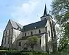 Kerk Saint-Médard | ||
| Chapel of Note Dame des Sept Douleurs (Seven Sorrows) (nl) (fr) |
Geldenaken | 50°42′49″N 4°50′58″E / 50.713679°N 4.849434°E |
25048-CLT-0003-01 Info |
|||
| Chapel of Notre Dame called "Chapelle du Marché" (nl) (fr) |
Geldenaken | 50°43′30″N 4°52′05″E / 50.725117°N 4.867949°E |
25048-CLT-0004-01 Info |
 Kapel Notre-Dame genaamd "Chapelle du Marché" | ||
| Remains of the ramparts of the city of Jodoigne (nl) (fr) |
Geldenaken | 50°43′30″N 4°52′12″E / 50.725016°N 4.870097°E |
25048-CLT-0005-01 Info |
|||
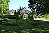
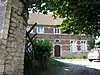
| castle Pastur (nl) (fr) |
Geldenaken | 50°43′29″N 4°52′00″E / 50.724771°N 4.866682°E |
25048-CLT-0006-01 Info |
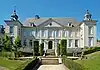 Kasteel Pastur | ||
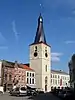
| town hall (nl) (fr) |
Geldenaken | 50°43′31″N 4°52′03″E / 50.725367°N 4.867512°E |
25048-CLT-0007-01 Info |
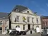 Raadhuis | ||
| Wall of the former convent of the Grey Nuns (Soeurs Grises) (nl) (fr) |
Geldenaken | rue du Sergent Sortet | 50°43′29″N 4°52′12″E / 50.724745°N 4.869952°E |
25048-CLT-0008-01 Info |
||
| The facades, roofs and cladding of all parts of the barn of the farm of Ramie and the surrounding area (nl) (fr) |
Geldenaken | 50°40′47″N 4°51′11″E / 50.679696°N 4.852983°E |
25048-CLT-0009-01 Info |
|||
| Castle of Jodoigne-Souveraine (nl) (fr) |
Geldenaken | 50°42′19″N 4°50′59″E / 50.705253°N 4.849653°E |
25048-CLT-0010-01 Info |
 Kasteel van Jodoigne-Souveraine | ||
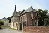
| Chapel of Herbais (nl) (fr) |
Geldenaken | 50°43′06″N 4°55′49″E / 50.718311°N 4.930209°E |
25048-CLT-0011-01 Info |
 Kapel van Herbais | ||
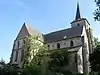
| Saint-Pierre Church: Romanesque tower and Romanesque-Gothic choir (nl) (fr) |
Geldenaken | 50°44′41″N 4°52′27″E / 50.744681°N 4.874299°E |
25048-CLT-0012-01 Info |
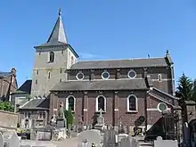 Kerk Saint-Pierre: romaanse toren en romaans-gotisch koor | ||
| Mill of Genville and the ensemble of the mill and surrounding area (nl) (fr) |
Geldenaken | 50°44′59″N 4°52′06″E / 50.749592°N 4.868217°E |
25048-CLT-0013-01 Info |
|||
| Chapel of Notre-Dame de Bon Secours and its immediate surroundings (nl) (fr) |
Geldenaken | 50°45′56″N 4°54′24″E / 50.765565°N 4.906630°E |
25048-CLT-0014-01 Info |
 Kapel Notre-Dame de Bon Secours en diens directe omgeving | ||
| Church of Saint-Barthélemy (nl) (fr) |
Geldenaken | 50°45′45″N 4°54′05″E / 50.762407°N 4.901371°E |
25048-CLT-0015-01 Info |
 Kerk Saint-Barthélemy | ||
| Chapel of Saint-Antoine and its environment (nl) (fr) |
Geldenaken | 50°44′24″N 4°47′34″E / 50.739910°N 4.792817°E |
25048-CLT-0016-01 Info |
|||
| Facades and roofs of the chapel of Sainte-Marie-Madeleine and its surroundings (nl) (fr) |
Geldenaken | 50°44′40″N 4°50′48″E / 50.744530°N 4.846801°E |
25048-CLT-0017-01 Info |
 Gevels en daken van de kapel Sainte-Marie-Madeleine en diens omgeving | ||
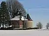
| Watermill "Conard" or "Charles" (nl) (fr) |
Geldenaken | rue de la Station n°9 | 50°42′24″N 4°50′39″E / 50.706616°N 4.844067°E |
25048-CLT-0019-01 Info |
||
| Organs of the church of Saint-Lambert (nl) (fr) |
Geldenaken | 50°43′24″N 4°51′52″E / 50.723210°N 4.864456°E |
25048-CLT-0021-01 Info |
|||
| Organs of the church of Saint-Martin (nl) (fr) |
Geldenaken | 50°43′24″N 4°49′28″E / 50.723196°N 4.824337°E |
25048-CLT-0022-01 Info |
|||
| Organs of the church of Notre-Dame de la Visitation (nl) (fr) |
Geldenaken | 50°44′22″N 4°49′39″E / 50.739433°N 4.827599°E |
25048-CLT-0023-01 Info |
|||
| Organs of the church of Sainte-Gertrude, now Church of Saint Gabriel (de l'Addolorata) (nl) (fr) |
Geldenaken | 50°43′06″N 4°55′49″E / 50.718377°N 4.930330°E |
25048-CLT-0024-01 Info |
|||
| Organs of the church of Saint-Barthélemy (nl) (fr) |
Geldenaken | 50°45′44″N 4°54′04″E / 50.762329°N 4.901195°E |
25048-CLT-0025-01 Info |
|||
| Presbytery: facades and roofs, and the surrounding wall (nl) (fr) |
Geldenaken | 50°44′24″N 4°49′38″E / 50.740016°N 4.827244°E |
25048-CLT-0026-01 Info |
 Pastorie: gevels en daken, en de omliggende muur | ||
| Facades and roofs of the farm Boues except the extensions (nl) (fr) |
Geldenaken | rue des Marchés n°s 10-12-14 | 50°43′34″N 4°52′06″E / 50.726184°N 4.868344°E |
25048-CLT-0028-01 Info |
||
| Ensemble of the church of Saint-Medard, except the organ (instrumental part and buffet) (nl) (fr) |
Geldenaken | 50°43′16″N 4°52′08″E / 50.721163°N 4.868924°E |
25048-PEX-0001-01 Info |
 Ensemble van de kerk Saint-Médard, uitgezonderd het orgel (instrumentaal deel en buffet) | ||
| Facades and roofs of the "ancien regime" style buildings of the courtyard of the farmhouse "de la Ramee" (nl) (fr) |
Geldenaken | 50°40′47″N 4°51′11″E / 50.679696°N 4.852983°E |
25048-PEX-0002-01 Info |
See also
Wikimedia Commons has media related to Cultural heritage monuments in Jodoigne.
References
- Belgian heritage register: Direction générale opérationnelle - Aménagement du territoire, Logement, Patrimoine et Energie (DG4)
- www.dglive.be
This article is issued from Wikipedia. The text is licensed under Creative Commons - Attribution - Sharealike. Additional terms may apply for the media files.