This table shows an overview of the protected heritage sites in the Walloon town Incourt, Belgium. This list is part of Belgium's national heritage.
| Object | Year/architect | Town/section | Address | Coordinates | Number? | Image |
|---|---|---|---|---|---|---|
| Tumulus of Glimes and surrounding area (nl) (fr) |
Incourt | 50°40′36″N 4°49′58″E / 50.676784°N 4.832763°E |
25043-CLT-0001-01 Info |
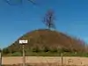 Tumulus van Glimes en omliggend terrein | ||
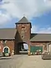
| Ruins of Opprebais castle: towers, keep, curtain walls and barn and ensemble formed by the ruins, church, cemetery and surrounding area (nl) (fr) |
Incourt | 50°40′58″N 4°47′48″E / 50.682692°N 4.796787°E |
25043-CLT-0003-01 Info |
.JPG.webp) Ruïnes van kasteel Opprebais: torens, donjon, gordijnen en schuur en ensemble gevormd door de ruïnes, kerk, begraafplaats en de omliggende terreinen | ||
| Farm of Chise: facades and roofs, and surrounding area (nl) (fr) |
Incourt | 50°44′20″N 4°45′40″E / 50.739023°N 4.761062°E |
25043-CLT-0004-01 Info |
 Boerderij van Chise: gevels en daken, en omliggende terreinen | ||
| Tumulus of Glimes and surrounding area (nl) (fr) |
Incourt | 50°40′36″N 4°49′58″E / 50.676784°N 4.832763°E |
25043-PEX-0001-01 Info |
Tumulus van Glimes en omliggend terrein |
See also
Wikimedia Commons has media related to Cultural heritage monuments in Incourt, Belgium.
References
- Belgian heritage register: Direction générale opérationnelle - Aménagement du territoire, Logement, Patrimoine et Energie (DG4)
- www.dglive.be
This article is issued from Wikipedia. The text is licensed under Creative Commons - Attribution - Sharealike. Additional terms may apply for the media files.