This table shows an overview of the protected heritage sites in the Walloon town Habay. This list is part of Belgium's national heritage.
| Object | Year/architect | Town/section | Address | Coordinates | Number? | Image |
|---|---|---|---|---|---|---|
| Washing place (nl) (fr) |
Habay | rue de la Fontaine | 49°43′36″N 5°32′07″E / 49.726743°N 5.535416°E |
85046-CLT-0001-01 Info |
Wasplaats | |
| Washing place (nl) (fr) |
Habay | rue de Grimodé | 49°42′34″N 5°31′58″E / 49.709351°N 5.532876°E |
85046-CLT-0002-01 Info |
Wasplaats | |
| Ensemble of Saint-Hubert chapel, surrounded by three lime trees and situated along the road to Habay la Vella (nl) (fr) |
Habay | 49°43′57″N 5°37′06″E / 49.732628°N 5.618386°E |
85046-CLT-0003-01 Info |
|||
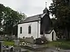
| Chapel Saint Hubert: interior and exterior (nl) (fr) |
Habay | rue de la Rochette 53, Habay-la-Vieille | 49°43′57″N 5°37′12″E / 49.732436°N 5.619999°E |
85046-CLT-0004-01 Info |
||
| Quarry and field (the 'Gentianes'), along the road between Ansart and Harinsart (nl) (fr) |
Habay | Rulles | 49°42′03″N 5°31′43″E / 49.700870°N 5.528697°E |
85046-CLT-0005-01 Info |
||
| Chapel Notre-Dame du Mont Carmel, the hexagonal walls of the old cemetery and all graves (nl) (fr) |
Habay | Rulles | 49°43′08″N 5°33′56″E / 49.718893°N 5.565637°E |
85046-CLT-0006-01 Info |
 Kapel Notre-Dame du Mont Carmel, de zeshoekige muur van de oude begraafplaats en alle graven |
See also
Wikimedia Commons has media related to Cultural heritage monuments in Habay.
References
- Belgian heritage register: Direction générale opérationnelle - Aménagement du territoire, Logement, Patrimoine et Energie (DG4)
- www.dglive.be
This article is issued from Wikipedia. The text is licensed under Creative Commons - Attribution - Sharealike. Additional terms may apply for the media files.