This table shows an overview of the protected heritage sites in the Walloon town Chaumont-Gistoux. This list is part of Belgium's national heritage.
| Object | Year/architect | Town/section | Address | Coordinates | Number? | Image |
|---|---|---|---|---|---|---|
| Church of Saint-Bavon: choir and tower (nl) (fr) |
Chaumont-Gistoux | 50°40′43″N 4°43′19″E / 50.678551°N 4.722008°E |
25018-CLT-0001-01 Info |
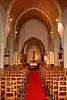 Kerk Saint-Bavon: koor en toren | ||
| Park "Les Bruyeres" (nl) (fr) |
Chaumont-Gistoux | 50°41′23″N 4°42′03″E / 50.689828°N 4.700845°E |
25018-CLT-0002-01 Info |
|||
| The pond and its surrounding area (nl) (fr) |
Chaumont-Gistoux | 50°41′18″N 4°41′32″E / 50.688308°N 4.692102°E |
25018-CLT-0003-01 Info |
|||
| Tumuli of Bonlez, two tumuli and surrounding area (nl) (fr) |
Bonlez Chaumont-Gistoux | 50°41′50″N 4°42′26″E / 50.697216°N 4.707175°E |
25018-CLT-0004-01 Info |
|||
| Organs of the church Saint-Etienne (nl) (fr) |
Chaumont-Gistoux | 50°39′41″N 4°40′28″E / 50.661455°N 4.674482°E |
25018-CLT-0005-01 Info |
|||
| Ensemble of the church of Saint-Martin and the churchyard, the rectory with outbuildings and the wooded park, the buildings of the old farmhouse and the square to which these buildings are aligned (nl) (fr) |
Chaumont-Gistoux | 50°42′56″N 4°39′40″E / 50.715504°N 4.661063°E |
25018-CLT-0006-01 Info |
|||
| Ensemble of the chapel of Cheneau and its surroundings (nl) (fr) |
Chaumont-Gistoux | 50°42′20″N 4°44′06″E / 50.705457°N 4.734997°E |
25018-CLT-0007-01 Info |
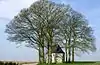 Ensemble van de kapel van Chêneau en zijn omgeving | ||
| Chapel of Cheneau (nl) (fr) |
Chaumont-Gistoux | 50°42′20″N 4°44′05″E / 50.705513°N 4.734861°E |
25018-CLT-0008-01 Info |
|||
| Organs of the church of Notre-Dame de l'Assomption (nl) (fr) |
Chaumont-Gistoux | 50°42′08″N 4°44′22″E / 50.702296°N 4.739332°E |
25018-CLT-0009-01 Info |
|||
| Sequoia tree, in the park of the castle of Bacque Laine (nl) (fr) |
Chaumont-Gistoux | 50°42′17″N 4°44′16″E / 50.704685°N 4.737904°E |
25018-CLT-0010-01 Info |
|||
| Driveway (nl) (fr) |
Chaumont-Gistoux | ruelle des Bois | 50°42′17″N 4°44′21″E / 50.704811°N 4.739036°E |
25018-CLT-0011-01 Info |
||
| Farm: dovecot, facades and roofs of the barn and the main building with the exception of the old pig shed (nl) (fr) |
Chaumont-Gistoux | rue de Chaumont, n°34 (M) et les abords (S). | 50°41′56″N 4°44′14″E / 50.698865°N 4.737170°E |
25018-CLT-0012-01 Info |
||
| Sunken road formed by the rue de Chaumont and the adjacent slope, from the intersection with the road d'Arnelle up to beyond the farm on No. 34 rue Chaumont (nl) (fr) |
Chaumont-Gistoux | Longueville | 50°41′31″N 4°44′05″E / 50.692019°N 4.734731°E |
25018-CLT-0013-01 Info |
||
| Organ of the church of Notre-Dame de l'Assomption (nl) (fr) |
Chaumont-Gistoux | 50°42′08″N 4°44′22″E / 50.702296°N 4.739332°E |
25018-PEX-0001-01 Info |
See also
Wikimedia Commons has media related to Cultural heritage monuments in Chaumont-Gistoux.
References
- Belgian heritage register: Direction générale opérationnelle - Aménagement du territoire, Logement, Patrimoine et Energie (DG4)
- www.dglive.be
This article is issued from Wikipedia. The text is licensed under Creative Commons - Attribution - Sharealike. Additional terms may apply for the media files.