This is a list of listed buildings in the parish of Cromdale, Inverallan and Advie in Highland, Scotland.
List
| Name | Location | Date Listed | Grid Ref. [note 1] | Geo-coordinates | Notes | LB Number [note 2] | Image |
|---|---|---|---|---|---|---|---|
| Tormore Distillery, Manager's House, Duty Free Warehouses, Distillery And Offices, Generator House, 1, 2 Richardson Road, Community Centre, 3-12A Richardson Road, Gate Piers | 57°23′55″N 3°24′29″W / 57.398493°N 3.407957°W | Category B | 337 |  Upload Photo | |||
| Castle Grant, East Lodge. Railway Bridge Over A939 Road And Entrance Arch To Drive | 57°21′07″N 3°36′32″W / 57.352037°N 3.608899°W | Category A | 349 | 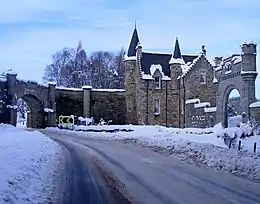
| |||
| Dava Bridge Over Dorback Burn | 57°25′49″N 3°39′34″W / 57.430289°N 3.659404°W | Category C(S) | 354 | Upload Photo | |||
| Cromdale Old Church Of Scotland Manse, Steading And Gatepiers | 57°20′28″N 3°32′59″W / 57.341072°N 3.549799°W | Category B | 5106 | Upload Photo | |||
| (Old) Spey Bridge Over River Spey | 57°19′03″N 3°35′45″W / 57.31745°N 3.595963°W | Category A | 335 | .jpg.webp)
| |||
| Cromdale Parish Church Burial Ground And Watch-House Church Of Scotland | 57°20′30″N 3°33′08″W / 57.341679°N 3.552267°W | Category B | 352 | Upload Photo | |||
| Castle Grant, Home Farm, Courtyard Range To South Including Walls And Gatepiers | 57°21′16″N 3°35′59″W / 57.354527°N 3.599584°W | Category C(S) | 48934 | Upload Photo | |||
| Castle Grant | 57°21′07″N 3°35′41″W / 57.352°N 3.594803°W | Category A | 348 | 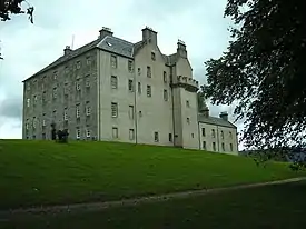
| |||
| Dulnain Bridge, Finlarig | 57°18′27″N 3°40′15″W / 57.30762°N 3.670756°W | Category C(S) | 355 | Upload Photo | |||
| Advie Old Manse (Former Church Of Scotland Manse) | 57°23′25″N 3°27′20″W / 57.390263°N 3.455441°W | Category C(S) | 345 | Upload Photo | |||
| Advie Parish Church, Church Of Scotland | 57°23′26″N 3°27′18″W / 57.390422°N 3.454915°W | Category C(S) | 344 | Upload Photo | |||
| Castle Grant, West Lodge, Gate Piers And Retaining Walls | 57°20′23″N 3°36′16″W / 57.339804°N 3.604393°W | Category B | 350 | Upload Photo | |||
| Lethendry Castle | 57°19′41″N 3°31′22″W / 57.327972°N 3.522688°W | Category C(S) | 334 | Upload Photo | |||
| (New) Spey Bridge Over River Spey | 57°19′18″N 3°36′22″W / 57.321571°N 3.606056°W | Category B | 336 | Upload Photo | |||
| Advie, Tulchan Lodge | 57°24′09″N 3°27′05″W / 57.402609°N 3.451304°W | Category B | 346 | Upload Photo | |||
| Castle Grant, Railway Bridge In Policies | 57°21′22″N 3°36′13″W / 57.356245°N 3.603631°W | Category B | 351 | Upload Photo | |||
| Dava, Loch Allan, Aa Sentry Box (No 746) | 57°25′43″N 3°39′35″W / 57.428524°N 3.659707°W | Category B | 49222 | Upload Photo | |||
| Advie Bridge Over River Spey | 57°23′59″N 3°27′55″W / 57.399798°N 3.465222°W | Category B | 343 | Upload Photo | |||
| Dava Bridge Over Allt Na Ceardaich | 57°25′28″N 3°39′38″W / 57.424344°N 3.660567°W | Category C(S) | 353 | Upload Photo |
Key
The scheme for classifying buildings in Scotland is:
- Category A: "buildings of national or international importance, either architectural or historic; or fine, little-altered examples of some particular period, style or building type."[1]
- Category B: "buildings of regional or more than local importance; or major examples of some particular period, style or building type, which may have been altered."[1]
- Category C: "buildings of local importance; lesser examples of any period, style, or building type, as originally constructed or moderately altered; and simple traditional buildings which group well with other listed buildings."[1]
In March 2016 there were 47,288 listed buildings in Scotland. Of these, 8% were Category A, and 50% were Category B, with the remaining 42% being Category C.[2]
See also
Notes
- ↑ Sometimes known as OSGB36, the grid reference (where provided) is based on the British national grid reference system used by the Ordnance Survey.
• "Guide to National Grid". Ordnance Survey. Retrieved 12 December 2007.
• "Get-a-map". Ordnance Survey. Retrieved 17 December 2007. - ↑ Historic Environment Scotland assign a unique alphanumeric identifier to each designated site in Scotland, for listed buildings this always begins with "LB", for example "LB12345".
References
- All entries, addresses and coordinates are based on data from Historic Scotland. This data falls under the Open Government Licence
- 1 2 3 "What is Listing?". Historic Environment Scotland. Retrieved 29 May 2018.
- ↑ Scotland's Historic Environment Audit 2016 (PDF). Historic Environment Scotland and the Built Environment Forum Scotland. pp. 15–16. Retrieved 29 May 2018.
This article is issued from Wikipedia. The text is licensed under Creative Commons - Attribution - Sharealike. Additional terms may apply for the media files.