| Kodori | |
|---|---|
.jpg.webp) | |
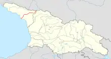 Kodori river (in red) on the map of Georgia. | |
   | |
| Location | |
| Country | Georgia/Abkhazia[1] |
| Physical characteristics | |
| Source | Kelasuri First / Kelasuri Second |
| • location | Main Caucasian Range Caucasus Major |
| • elevation | 1,380 m (4,530 ft) |
| Mouth | Georgia/Abkhazia[1] |
• location | Black Sea |
• coordinates | 42°49′14″N 41°07′55″E / 42.82056°N 41.13194°E |
• elevation | 0 ft (0 m) |
| Length | 105 km (65 mi) |
| Basin size | 2,051 square kilometres (792 sq mi) |
| Discharge | |
| • average | 144 m3/s (5,100 cu ft/s) |
The Kodori (Georgian: კოდორი; Abkhaz: Кәыдры, romanized: Kwydry) is one of the two largest rivers of Abkhazia,[1] along with the Bzyb. It is formed by the joining of the rivers Sakeni and Gvandra. The Kodori is first among Abkhazia's rivers with respect to average annual discharge at 144 cubic metres per second (5,100 cu ft/s) and drainage basin area at 2,051 square kilometres (792 sq mi). It is second after the Bzyb with respect to length at 105 kilometres (65 mi) when combined with the Sakeni.[2]
See also
- Kodori Valley for the valley through which the Kodori flows.
References
Wikimedia Commons has media related to Kodori River.
- 1 2 3 The political status of Abkhazia is disputed. Having unilaterally declared independence from Georgia in 1992, Abkhazia is formally recognised as an independent state by 5 UN member states (two other states previously recognised it but then withdrew their recognition), while the remainder of the international community recognizes it as as de jure Georgian territory. Georgia continues to claim the area as its own territory, designating it as Russian-occupied territory.
- ↑ Dbar, Roman (1999). "Geography & The Environment". In George Hewitt (ed.). The Abkhazians - a handbook. Caucasus World; Peoples of the Caucasus & the Black Sea. Richmond, Surrey: Curzon. ISBN 0-7007-0643-7.
This article is issued from Wikipedia. The text is licensed under Creative Commons - Attribution - Sharealike. Additional terms may apply for the media files.