Zion's Hill | |
|---|---|
.jpg.webp) Hell's Gate | |
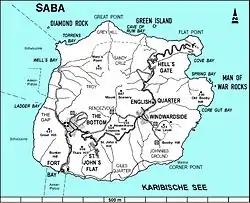 Map of Saba showing Zion's Hill | |
| Coordinates: 17°38′35″N 63°13′37″W / 17.64306°N 63.22694°W | |
| Country | |
| Public body | |
| Elevation | 300 / 450 m (1,000 / 1,480 ft) |
| Population (2001)[1] | |
| • Total | 283 |
| Time zone | UTC-4 (AST) |
| Climate | Aw |
Zion's Hill, also known by its former name Hell's Gate, is a town on the Dutch Caribbean island of Saba.[2]
Hell's Gate is divided into Upper Hell's Gate and Lower Hell's Gate. Upper Hell's Gate is the highest village in the Kingdom of the Netherlands, at an altitude of 450 meters above sea level. Lower Hell's Gate is located approximately 300 meters above sea level. The village also includes the lower Flat Point, location of the Juancho E. Yrausquin Airport and the Flat Point Tide Pools.
History
Hell's Gate was officially named "Zion's Hill" after complaints from the church forced the island's government to change the name. However, "Hell's Gate" is still commonly used by many Sabans and tourists.[3]
Main sights
Hell's Gate is home to Queen of The Holy Rosary Church, a stone structure built in 1962,[3] as well as a community center where visitors can purchase locally made Saba lace and Saba spice, a locally brewed rum drink.
Hiking trails
Upper Hell's Gate is a trailhead for the Sandy Cruz Trail, which ends in The Bottom.[4] The trail takes roughly 2 hours to complete (2.5 if begun in The Bottom), and has views of Diamond Rock and the northern coastline.[2][4]
Lower Hell's Gate is home to the McNish Sulfur Mine, a now-closed sulfur mine where visitors may explore with caution.[5][4] It can be reached via the Sulphur Mine Trail, which begins between Upper and Lower Hell's gate.[4] It is part of Saba's Terrestrial Park. The trail has views of Green Island, the ocean, cliffs, and the airport.[4] Lower Hell's Gate is also the main trailhead for the North Coast Trail. The trail takes roughly 3.5 hours to complete and has views of Saba's northern coastline and the ruins of the historic Mary's Point village.[2][4]
Flat Point is the main trailhead for the Flat Point Trail.[6][7] The hike leads to the Flat Point Tide Pools, and is about 15–25 minutes each way.[6][8] The trail passes by the ruins of an indigo boiling house from a 17th-18th century plantation.[8][9] The trail access is located between the airport and Cove Bay. Hikers are cautioned about rip currents and sharp rocks.[10][11]
Transport
Zion's Hill is the first town one reaches after leaving the Juancho E. Yrausquin Airport, the smallest commercial airport in the world.[12]
See also
- Mount Scenery
- Flat Point Tide Pools
- Juancho E. Yrausquin Airport
References
- ↑ "Geodata 2001, Saba & Sint.Eustatius, Census 2001". Centraal Bureau voor de Statistiek, Netherlands Antilles. 2001. p. 17. Retrieved 3 May 2021.
- 1 2 3 The villages of Saba (Saba Tourist Bureau)
- 1 2 "About Saba". Saba Tourisma. Retrieved 5 May 2021.
- 1 2 3 4 5 6 "Plan your Hike". Saba Conservation Foundation. Retrieved 2024-01-10.
- ↑ "About Saba: Zion's Hill (A.k.a. Hell's Gate)". Saba Tourism. 2018-06-21. Retrieved 2024-01-10.
- 1 2 "Hiking | Saba Tourism". 2022-03-10. Retrieved 2024-01-11.
- ↑ "The Nature of Saba [brochure]" (PDF). www.sabatourism.com. Saba Conservation Foundation.
- 1 2 "The Nature of Saba [brochure]" (PDF). www.sabatourism.com. Saba Conservation Foundation.
- ↑ Espersen, Ryan (2019-01-01). "A Site Report of Flat Point, Saba, Dutch Caribbean: A Ceramic-Age Amerindian Site and Early Colonial Sugar and Indigo Plantation". Zemi Cultural Heritage Services site reports.
- ↑ Allen, Casey D. (2017-07-19). Landscapes and Landforms of the Lesser Antilles. Springer. ISBN 978-3-319-55787-8.
- ↑ "The Tide Pools - Saba". ArrivalGuides.com. 2023-03-22. Retrieved 2024-01-12.
- ↑ Fodor's; Roth, Melanie A. (1994). Caribbean '95: The Complete Guide to Choosing and Enjoying the Perfect Island Vacation. Fodor's Travel Publications. p. 443. ISBN 978-0-679-02705-8.
External links
![]() Media related to Zion's Hill at Wikimedia Commons
Media related to Zion's Hill at Wikimedia Commons
| Populated places | |||
|---|---|---|---|
| Other locations | |||
| Transport | |||
| Education | |||
| Heraldry | |||
| Culture | |||