Dorndorf-Steudnitz | |
|---|---|
 Coat of arms | |
Location of Dorndorf-Steudnitz | |
 Dorndorf-Steudnitz  Dorndorf-Steudnitz | |
| Coordinates: 51°0′N 11°40′E / 51.000°N 11.667°E | |
| Country | Germany |
| State | Thuringia |
| District | Saale-Holzland-Kreis |
| Municipal assoc. | Dornburg-Camburg |
| Town | Dornburg-Camburg |
| Area | |
| • Total | 7.01 km2 (2.71 sq mi) |
| Elevation | 135 m (443 ft) |
| Population (2006-12-31) | |
| • Total | 1,930 |
| • Density | 280/km2 (710/sq mi) |
| Time zone | UTC+01:00 (CET) |
| • Summer (DST) | UTC+02:00 (CEST) |
| Postal codes | 07778 |
| Dialling codes | 036427 |
| Website | dorndorf-steudnitz.de |
Dorndorf-Steudnitz is a former municipality in the district Saale-Holzland, in Thuringia, Germany. Since 1 December 2008, it is part of the town Dornburg-Camburg.
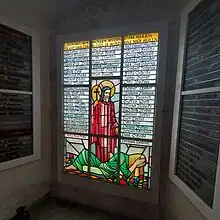
War memorial in Leadlight
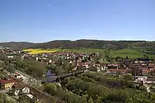
view from Altes Schloss, with the Carl Alexander bridge.
Its most important historical building is St. Peters Church, which connects baroque architecture with later additions such as a World War memorial, and the Carl Alexander bridge from 1892 spanning the river Saale.
This article is issued from Wikipedia. The text is licensed under Creative Commons - Attribution - Sharealike. Additional terms may apply for the media files.