Orangi District
ضلع اورنگی | |
|---|---|
District of Karachi | |
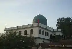 Shrine of Pir Mangho in Manghopir | |
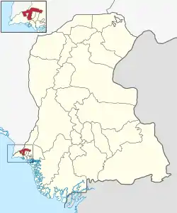 Map of Orangi District | |
| Country | |
| Province | |
| Division | Karachi |
| Established | 1972 |
| Re-established | 11 July 2011 |
| Headquarters[1] | DMC West |
| Government | |
| • Type | Municipal corporation |
| • Body | DMC West |
| • Deputy Commissioner | Ahmed Ali Siddiqui[3] |
| Area | |
| • Total | 370 km2 (140 sq mi) |
| Population | |
| • Total | 2,679,380 |
| • Density | 7,200/km2 (19,000/sq mi) |
Orangi District (formerly Karachi West District) (Urdu: ضلع اورنگی) is an administrative, one of 7th district of Karachi Division in Sindh, Pakistan.
History
The District was abolished in 2000 and divided into five towns namely:
On 11 July 2011 Sindh Government restored again Karachi West District.[5]
In 2020, Kemari District was carved out from Karachi West District. So Keamari Town, SITE Town and Baldia Town ended up being part of Kemari District. Lyari became part of Karachi South district in 2015.[6][7][8]
As of 2023, Sindh Government renamed Karachi West District to its famous town name Orangi District
Demographics
At the time of the 2017 census, Orangi district had 337,205 households and a population of 2,077,228. Jamshoro had a sex ratio of 920 females per 1000 males and a literacy rate of 68.29%: 71.27% for males and 65.03% for females. 1,916,324 (92.25%) lived in urban areas. 536,576 (25.83%) were under 10 years of age.[9] In 2023, the district had 465,197 households and a population of 2,679,380.[4]
The majority religion is Islam, with 98.06% of the population. Christianity is practiced by 1.61% of the population.[9]
At the time of the 2017 census, 50.27% of the population spoke Urdu, 26.19% Pashto, 6.13% Punjabi, 3.83% Saraiki, 3.57% Sindhi, 3.09% Hindko, 2.70% Balochi and 1.07% Brahui as their first language.[9]
Administrative Towns in Orangi District
Following is the list of three administrative towns of Orangi District Karachi.
- Mominabad Sub-Division
- Manghopir Sub-Division
- Orangi Town Sub-Division
Orangi Town
| Union Council |
|
|---|---|
| U.C. 1 Mominabad | |
| U.C. 2 Haryana Colony | |
| U.C. 3 Hanifabad | |
| U.C. 4 Mohammad Nagar | |
| U.C. 5 Madina Colony | |
| U.C. 6 Ghaziabad | |
| U.C. 7 Chisti Nagar | |
| U.C. 8 Bilal Colony | |
| U.C. 9 Iqbal Baloch Colony | |
| U.C. 10 Gabol Colony | |
| U.C. 11 Data Nagar | |
| U.C. 12 Mujahidabad | |
| U.C. 13 Baloch Goth | |

List of Dehs
The following is a list of Orangi District's dehs, organised by taluka:[10]
See also
References
- ↑ "ADMINISTRATIVE DISTRICTS". Commissioner, Karachi Division.
- ↑ "Under SC judgement: Sindh govt repatriates 32 officials of Karachi DMC to parent depts". The News International (newspaper). 22 February 2021. Retrieved 11 January 2022.
- ↑ "DCs of Karachi's four districts replaced". The Nation (newspaper). 27 July 2021. Retrieved 11 January 2022.
- 1 2 "TABLE 1 : HOUSEHOLDS, POPULATION, HOUSEHOLD SIZE AND ANNUAL GROWTH RATE" (PDF). www.pbscensus.gov.pk. Pakistan Bureau of Statistics. 2023.
- ↑ Karachi’s district status restored, notification issued, Published in The News Tribe on 11 July 2011, Retrieved on 7 August 2012
- ↑ "Karachi fits seventh district into its mix – Keamari | SAMAA". Samaa TV. Retrieved 23 August 2020.
- ↑ "Ruckus in Sindh Assembly as opposition protests Kemari district decision | Pakistan Today". www.pakistantoday.com.pk. Retrieved 23 August 2020.
- ↑ "Sindh Cabinet approves division of Karachi into seven districts". The Nation. 21 August 2020. Retrieved 23 August 2020.
- 1 2 3 4 "District Wise Results / Tables (Census - 2017)". www.pbscensus.gov.pk. Pakistan Bureau of Statistics.
- ↑ "List of Dehs in Sindh" (PDF). Sindh Zameen. Retrieved 22 March 2021.
24°52′58″N 66°58′29″E / 24.8829°N 66.9748°E
Provincial capital: Karachi | ||
| Banbhore |  | |
| Hyderabad | ||
| Karachi | ||
| Larkana | ||
| Mirpur Khas | ||
| Sukkur | ||
| Shaheed Benazir Abad | ||