This list includes properties and districts listed on the California Historical Landmark listing in Trinity County, California. Click the "Map of all coordinates" link to the right to view a Google map of all properties and districts with latitude and longitude coordinates in the table below.
| Image | [1] | Landmark name | Location | City or town | Summary |
|---|---|---|---|---|---|
_-_South_Fork_Trinity_River_Bridge%252C_State_Highway_299_spanning_South_Fork_Trinity_River%252C_Salyer%252C_HAER_CAL%252C53-SALY.V%252C1-19.tif.jpg.webp) La Grange Mine |
778 | La Grange Mine | State Hwy 299 40°44′28″N 122°59′26″W / 40.741111°N 122.990556°W / 40.741111; -122.990556 (La Grange Mine) |
Weaverville | |
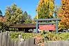 Weaverville Joss House |
709 | Weaverville Joss House | Weaverville Joss House State Historic Park 40°43′52″N 122°56′27″W / 40.7311°N 122.9408°W / 40.7311; -122.9408 (Weaverville Joss House) |
Weaverville |
References
- ↑ "California Historical Landmarks By County". Ohp.parks.ca.gov. Retrieved 2019-04-03.
See also
Wikimedia Commons has media related to California Historical Landmarks in Trinity County, California.
- List of California Historical Landmarks
- National Register of Historic Places listings in Trinity County, California
This article is issued from Wikipedia. The text is licensed under Creative Commons - Attribution - Sharealike. Additional terms may apply for the media files.