| Bearfort Mountain | |
|---|---|
| Bearfort Ridge | |
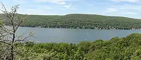 Bearfort Mountain (left), Bellvale Mountain (right) | |
| Highest point | |
| Peak | Bearfort Mountain |
| Elevation | 1,479 ft (451 m) |
| Coordinates | 41°8′14″N 74°23′52″W / 41.13722°N 74.39778°W |
| Geography | |
| Country | United States |
| State | New Jersey |
| Geology | |
| Age of rock | Devonian |
| Type of rock | Skunnemunk Conglomerate |
Bearfort Mountain, historically known as Bear Ford Mountain,[1] is a mountain ridge located near Wawayanda State Park in West Milford, Passaic County, New Jersey.[2] It is a continuation of Bellvale Mountain in New York. The Appalachian Trail crosses along the ridge into New York.[3] Puddingstone of the Skunnemunk Conglomerate is visible along the ridge.[4]
At an elevation of 1,331 feet (406 m) the ridge is the site of a 68 feet (21 m) high fire lookout tower built by the New Jersey Forest Fire Service.[5][6]
The mountain was depicted in an 1850 painting by Jasper Francis Cropsey, an American landscape artist of the Hudson River School.[7]
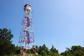 Bearfort Ridge Fire Tower
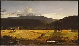 Bareford Mountains, West Milford, New Jersey by Jasper Francis Cropsey, 1850
See also
References
- ↑ "Bearfort Mountain". Geographic Names Information System. United States Geological Survey, United States Department of the Interior.
- ↑ "Bearfort Mountain, New Jersey". Peakbagger.com.
- ↑ "State Line Trail/Ernest Walter Trail/A.T. Loop from Greenwood Lake Marina". New York–New Jersey Trail Conference.
- ↑ "Bearfort Mountain". U.S. Geological Survey.
- ↑ National Historic Lookout Register, Bearfort Fire Tower US 244, NJ 6 Archived 2015-09-30 at the Wayback Machine. Retrieved 24 April 2015.
- ↑ New Jersey Forest Fire Service, "Wildfire Suppression: Division A Fire Towers". Retrieved 24 April 2015.
- ↑ "Bareford Mountains, West Milford, New Jersey". Brooklyn Museum.
This article is issued from Wikipedia. The text is licensed under Creative Commons - Attribution - Sharealike. Additional terms may apply for the media files.