Arthua | |
|---|---|
panchayet (village) | |
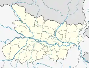 Arthua Location in Bihar, India  Arthua Arthua (India) | |
| Coordinates: 24°49′N 84°39′E / 24.82°N 84.65°E | |
| Country | |
| State | Bihar |
| District | Aurangabad district |
| Elevation | 89 m (292 ft) |
| Languages | |
| • Official | Maithili, Hindi |
| Time zone | UTC+5:30 (IST) |
Arthua is a panchayat (village) in Aurangabad district in the Indian state of Bihar.
Language
The languages of Arthua are Hindi and Urdu and most of the villagers speak both.
Transportation
The nearest railway station to Arthua is Rafiganj, located around 9.1 kilometer away. Other railway stations and their distance from Arthua are:
| Guraru railway station | 18.7 km. |
| Jakhim railway station | 26.3 km. |
| Gaya Jn railway station | 38.8 km. |
Arthua's nearest airport is Gaya International Airport located at a distance of 33.9 km away. Another airport around Arthua is Lok Nayak Jayaprakash Airport, 136.1 km removed from Arthua.
Education
Schools in the Arthua area are:
| Arthua High School | 0.7 km. |
| Urdu Middile School Budhaul | 4.3 km. |
| Pirwan Middle School | 6.7 km. |
References
This article is issued from Wikipedia. The text is licensed under Creative Commons - Attribution - Sharealike. Additional terms may apply for the media files.